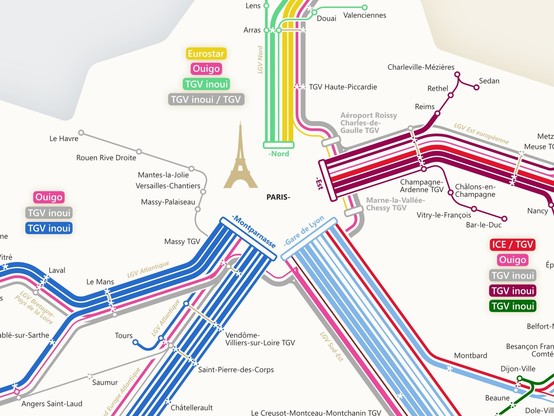
A few months ago I made a network map showing the high speed rail connections in #France. Unfortunately, the official #SNCF #TGV map only shows the stops and whether there is a connection or not. However, I wanted to better understand which cities and regions are directly connected.
Voilà the 2024 update of my 🇫🇷 high speed rail map! Feel free to explore and boost!

https://larstransportmaps.com/2024/03/11/high-speed-rail-in-france-2024/

High-Speed Rail in France 2024

My high-speed rail France map has got an update for 2024. There have not been major changes concerning the high-speed connections. However, already in autumn 2023, the brands of Eurostar and Thalys…

lars' transport maps
@larstransportworld wow cool map, even if I don’t use it, it is a very nice graphical representation
@larstransportworld
Hochgeschwindigkeitszüge sind gut, aber am Beispiel Schweiz sieht man, daß Pünktlichkeit und Verlässlichkeit Vorrang haben sollten.
@larstransportworld It still is a network with a star topology. Paris is the center of the French world!
@larstransportworld Really shows how people who decide where these connections should be live in Paris...
@Varpie @larstransportworld No. It just shows that LGV are designed from Paris.
The connections just use older railway links around Paris.
@larstransportworld
En Bretagne, juste avant Brest, la ville s'écrit Landerneau.
Très belle carte !
@flore Merci! Je vais corriger le nom.
@larstransportworld Superbe travail ! J'aurai adoré connaître les détails de sa conception, mais j'imagine que réaliser la carte elle-même est déjà un sacré boulot :)
@larstransportworld Thank you. this is coming just about the night time and will help me find a way back

@larstransportworld I love your map. Luckily my local area with Augsburg is included.

So I can hopp to Paris (which I already knew).

With your map I have some new ideas. For example 3h to Strassbourg, stay there a few days and then 6h to Montpellier.

I guess I have a new entry on my bucket list. Thank you!

@larstransportworld pour info, le bouton de download ne fonctionne pas sur mon portable (Android).
@brunogirin Dommage! Quel navigateur utilises-tu? Je crains de ne pas pouvoir changer grand-chose, car j'utilise simplement les fonctions de base de Wordpress.
@larstransportworld Firefox pour Android. C'est pas grave, j'essaie de nouveau à la maison 🙂
@brunogirin J'utilise aussi Firefox pour Android. Désolé, je ne sais pas ce qui ne va pas. 😐

@PolGM @larstransportworld Wow merci, c'est exactement ce que je cherchais.

Ça montre que représenter ce réseau en étoile est un vrai défi !

@larstransportworld incroyable, je découvre des lignes directes que je connaissais pas avant !

@larstransportworld Great work ! I'm working on an interactive public transport map of France.

Representing direct vs non direct trains is a challenge. I'll study your work. It won't be this beautiful.

https://elk.zone/boitam.eu/@maeool/112083014033523984

Maël (@[email protected])

Attached: 1 image Lignes SNCF cartographiées *en prenant en compte la fréquence*, avec affichage des trajets directs. Ça permet de visualiser une densité des lignes : j'aurai peu de Paris-Brest directs, mais beaucoup de directs Paris-Rennes. Encore une confirmation que ce réseau est avant tout géré pour les parisiens. (Avec probablement des données manquantes, vu la Normandie. À moins que leur liaisons TER soient dans le jeu de données de la région, à explorer)

boitam.eu
@maeool Great! Interactive maps are always a big extra!

@larstransportworld Very cool (and so much better than the official one).

Small thing: rather than "plus que sept trains par jour" it should be "plus de sept trains par jour". Same thing for "moins que quatre", should be "moins de quatre".

@larstransportworld Very useful, thanks! I think the NW needs a little icon though, maybe something like this: 🌧️
@larstransportworld Fortunately there are foreigners like you to do what SNCF is unable to do.
Thank you so much it's a very legible and beautiful map.
@larstransportworld Great work !
Do you know that if everything you put on the map are lines taken by high speed capable trains (TGV), not all portions allow these trains to go at high speed ?
For instance, Bordeaux to Toulouse is not at high speed yet.
@larstransportworld Cf. "Operational high-speed lines in Europe" map in en.wikipedia "High-speed rail in Europe" article.
@larstransportworld franchement, vu comme ça je découvre des trajets insoupçonnés ! Bravo et merci 🤩
@larstransportworld
(Just FYI, in the legend box, "septe" is wrong, it's only "sept". The 2023 map has this error as well, but some more too)
@Cqoicebordel Thank you. I have already corrected it in the meantime for the 2024 map.
@larstransportworld
Une excellente carte, merci pour la création / le partage !
Une erreur potentielle (mais c'est peut-être moi): Le TGV Paris (Lyon) - Genève s'arrête dans mon expérience à Bellegarde avant Genève et pas Nurieux.
Voilà, ce n'est pas important et ça ne change rien à l'utilité extrême de cette carte pour planifier des voyages !
@jicka Merci. Il y a un train par jour qui s'arrête à Nurieux et Bellegarde. C'est pourquoi l'arrêt à Nurieux est représenté par un cercle en pointillés. Mais je suppose que le placement des gares peut prêter à confusion. C'est un peu étroit.
@larstransportworld
Aaaah compris. Merci de la clarification, c'est très intéressant !
@larstransportworld Great map, maybe a hint: there is one TGV (almost) each Saturday from Freiburg to Bordeaux. Don't know if you do those, but it's a handy connection from Germany bypassing Paris terminus stations.
@spyonmetoo Thank you! I can imagine that this connection can be quite nice. Since it only runs once a week, I didn't include it. Anyway, you are not the first to miss it, so maybe I should consider changing my mind 😄 However, especially in France, showing every single connection would be very overloaded...
@larstransportworld I mean there is a simple answer to the question. "Paris is connected. The rest is just there as decoration". Yes, our train "network" is stupidly one-siided.