Am at the first #OpenET applications conference, with another 200+ water folks. Won't be live-tooting too much, but a few bits will trickle out because I'm excited to support this great community focused on using open to meet the deep challenge of climate adaptation.
Opening with a presentation on the core science team's recent Nature Water cover piece, discussing their (our?) techniques for validating estimations of evapo-transpiration from satellite data: https://www.nature.com/articles/s44221-023-00181-7

Assessing the accuracy of OpenET satellite-based evapotranspiration data to support water resource and land management applications - Nature Water
Assessing the accuracy of evapotranspiration (ET) data is crucial for managing the water used by crops and natural vegetation. This study presents a comprehensive evaluation of the accuracy of a remotely sensed ET model ensemble from the OpenET system using in situ ET measurements collected across the contiguous United States.
If you're wondering what evapotranspiration is, I've rewritten part of the Wikipedia article but it still needs love: https://en.wikipedia.org/wiki/Evapotranspiration

Current speaker talking about how Google Earth Engine isn't optimal for a specific type of iterative model, so he ran a slightly tweaked version on the computer "where he works", which is nice when where you work is https://www.nas.nasa.gov/
I wish I could talk with my grandfather (who worked at NASA) about this slide. So many satellites!
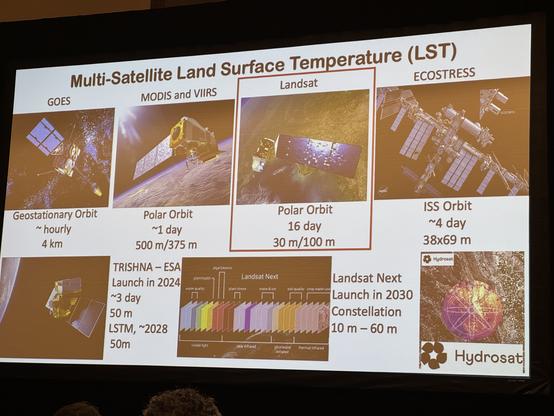
@luis_in_brief I fucking love those stacked wavelength illustrations of coverage every time I see them.
@danhon right?