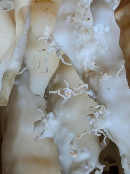
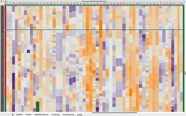
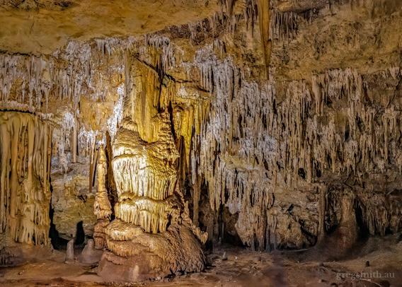
New paper out today by my #MPIC colleague (and officemate/friend) Sam Nicholson, who looked at the climatic constraints on speleothem deposition in SW Asia - to the surprise of no-one who spends any time thinking about speleothem deposition, it's not straightforward!

https://pubs.geoscienceworld.org/gsa/geology/article/doi/10.1130/G54103.1/723985/The-climatic-constraints-on-speleothem-deposition

#speleothem #Karst #paleoclimate #geology

#Cave #CavePhotography #CellPhonePhotography #Speleothem #Helictites. Taken in Cosmic Caverns, Berryville Arkansas USA

I did something.
It's about the ColdBlob or SubPolarGyre or AMOC.
Specifically, about finding proxy locations on land for its annual evolution.

Taking SPG average sst in the months DJF and MAM, and computing also their year-on-year growth rate.

Then I computed the growth rate for DJF and MAM in all coordinates on land using Era5-Land 1951-2025.
And when the growthrate matches that of SPG within ±0.5 °C, it gets a ✅ .
6 ✅ per decade gets a 🔵 and counts toward selection.
Some more exclusion criteria applied, and I get a list of 315 locations on land for 🔵matching DJF growthrate, and a whopping additional 11,460 locations for MAM
In a 0.1x0.1 grid.

All DJF locations are in Papua. No proxies I know of have been recovered from Papua yet. I know all speleothems / stalagmites in caves🔴 , and all treerings ever analyzed🟢 , thanks to #NOAA .

But MAM °C has more locations. All of Indonesia basically is THE SPG in terms of growthrate. A few trees and speleothems match, one cave covers the whole #Holocene 🖖🏽
Large patches in Africa also match SPG in MAM. But only 2 short treering studies exist. No caves.
Middle and South America has plenty matching SPG MAM too, and a handful of trees and caves.

Yay.

#AMOC #climateChange #citizenscience #proxy #climateproxies #ColdBlob #SubPolarGyre
#Speleothem #treerings

Interesting paper out recently in ClimPast - subaquous speleothems record groundwater recharge in Mairs Cave, South Australia.

https://cp.copernicus.org/articles/21/857/2025/

#AusQuaternary #speleothem

Subaqueous speleothems as archives of groundwater recharge on Australia's southern arid margin

Abstract. As anthropogenic climate change enhances aridity across many regions of the globe, understanding drivers of aridification is more important than ever before. Unfortunately, arid regions globally tend to exhibit a paucity of palaeoclimate records, and the archives that are available typically comprise unconsolidated sediments prone to reworking, large dating uncertainties, and ambiguous climatic interpretations. This is certainly true of Australia's vast continental interior, which is dominated by harsh, arid conditions. Mairs Cave, in the southern Ikara-Flinders Ranges (South Australia), is located on the southern margin of the arid zone. In the present day, the cave is largely dry, and there is limited evidence of active speleothem growth. However, historical records and observations throughout the cave indicate that it was periodically flooded, suggesting the local water balance was once much more positive than it is today. The cave contains a curtain of hanging speleothems known as pendulites, which grow subaqueously when submerged in water that is saturated with respect to calcite. Geochemical evidence, including trace element concentrations, uranium isotope ratios, and dead carbon fractions (DCFs), indicates that a rise in the local groundwater during periods of enhanced groundwater recharge is the cause of the cave flooding events that trigger pendulite growth. Uranium–thorium dating of a pendulite retrieved from Mairs Cave has revealed two multi-millennial growth phases (68.5–65.4 and 51.2–42.3 ka) and two short bursts of growth (18.9 and 16.4 ka) during the Last Glacial Period (LGP). The absence of subsequent pendulite growth suggests that strong water deficits under warm Holocene interglacial conditions give rise to episodic, rather than persistent, cave flooding.

Always a good day when friends have a good day! Out today in NATURE (!) from Monika Markowska - 8 million year record of recurrent humid phases in Arabia.

https://www.nature.com/articles/s41586-025-08859-6

#Quaternary #QuaternaryScience #speleothem #speleothems #palaeoclimate

Recurrent humid phases in Arabia over the past 8 million years - Nature

A climatic record from desert speleothems shows that the central Arabian interior experienced recurrent humid intervals over the past 8 million years, which likely facilitated mammalian dispersals between Africa and Eurasia.

Nature
Too old, too dirty, to unradiogenic? Can’t use your #speleothem? Don’t despair! ITL dating is here to help you out! https://www.sciencedirect.com/science/article/pii/S1871101424001328 speleoseb.bsky.social @sumikotsuka.bsky.social
Isothermal thermoluminescence dating of speleothem growth – A case study from Bleßberg cave 2, Germany

Speleothems are a key archive of past climatic and environmental changes. 230Th/U dating is the most commonly used method to determine speleothem ages…

@michcampbell

Interesting.
From what I recall from a few papers I read, the Mediterranean, or #MENA, experienced droughts in the 4.2ky event.

But figure 4 in the new literature review by #McKay et al 2024 shows a decidedly wet excursion for MENA: https://www.nature.com/articles/s41467-024-50886-w

They do mention the #Mediterranean and say, it were a complex and not at all clear case whether a drought was gripping the region or not.

So I pulled #d18O from cave #speleothem in the database " #Sisal3 " and plotted all those with okay resolution during the 4.2ky event.
The time span of the selection goes from 8.5ky to 2ky, like in McKay's paper.
My cave selection goes from longitude -9° to 85°E.
Locations are in the Google map, with the info whether it was dryer🔴 or wetter🌀 at 4.2ky.

A 3-colour-coded heatmap for the 50th percentile of d18O shows orange as drought and blue as wet.
More info in the ALT texts.

Conclusion: the mediterranean DID get dryer in the 4.2ky event. 🙂 🖖

#paleoclimate #holocene #drought

The 4.2 ka event is not remarkable in the context of Holocene climate variability - Nature Communications

A study of more than 1000 paleoclimate datasets reveals that the ”4.2 ka event” is not a globally significant climate excursion, unlike the prominent 8.2 ka event. In the Holocene, site-level excursions are common, but global-scale events are rare.

Nature

Just published in Organic Geochemistry, "Fire-induced shifts in stalagmite organic matter mapped using Synchrotron infrared microspectroscopy", led by #ANSTO colleague Dr. Liza McDonough. We demonstrate for the first time that Synchrotron IRM is a promising non-destructive, high resolution (5 µm) technique for analysing stalagmite organic matter. The paper can be found #OpenAccess here: https://doi.org/10.1016/j.orggeochem.2024.104842

#speleothem #stalagmite #organicMatter #pastClimate #geochemistry #UNSW

@Andbaker

Fire-induced shifts in stalagmite organic matter mapped using Synchrotron infrared microspectroscopy

Understanding organic matter (OM) in cave mineral deposits (speleothems) is essential for interpreting land use and climatic changes, and the incorpor…

The "Wedding Cake" speleothem formation in the Alexandra Cave, Naracoorte.

Stalagmites stand mightily, stalactites hang tightly.

#nature #caves #naracoortecaves #speleothem #stalagmite #stalactite #weddingcake #naracoorte #southaustralia

"Forests moderate local climate by keeping their local environments cool. They do this partly by shading the land, but also by releasing moisture from their leaves. This process, called transpiration, requires energy, which is extracted from the surrounding air, thus cooling it. A single tree can transpire hundreds of liters of water in a day. Each hundred liters has a cooling effect equivalent to two domestic air conditioners for a day, calculates Ellison."

https://e360.yale.edu/features/how-deforestation-affecting-global-water-cycles-climate-change

It's now part of my new #Tegtmeier project: figure out how much eg. European and American land use change has impacted local, regional and continental weather. See above posting where I asked this question, too.

So I plot #treering widths alongside d18O from #speleothem (eg. stalagmite). Both proxies are precisely dated and (can) have annual resolution.

I would expect to see a warming =
trees grow more when, at locations from where "their weather comes", other forests are felled .
And a drying =
d18O increase in speleothems.

I use #GoogleEarth and my rudimentary history knowledge to determine certain locations in Australia, New Zealand, USA and Europe. tbc.🍿

#paleoclimate #ECS #climateModel

Rivers in the Sky: How Deforestation Is Affecting Global Water Cycles

A growing body of evidence indicates that the continuing destruction of tropical forests is disrupting the movement of water in the atmosphere, causing major shifts in precipitation that could lead to drought in key agricultural areas in China, India, and the U.S. Midwest.  

Yale E360