#CAwx #SGX #graphicast
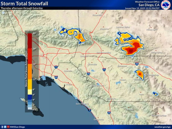
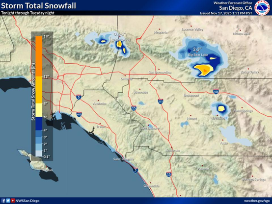
Snow above 6,500 ft expected Thursday and Friday with heavy snow possible above 7,000 feet. Total snow accumulations up to 5 to 10 inches possible with up to 16 inches possible in the mountain peaks. Light accumulations possible down to 6,000 feet.
#CAwx #SGX #graphicast
Widespread showers with a 15% chance of thunderstorms Thursday afternoon into Friday night. Lighter more scattered showers expected Saturday.
#CAwx #SGX #graphicast
High temperatures Friday will be 5 to 15 degrees below seasonable average.
#CAwx #SGX #graphicast
Thursday high temperatures will be 5 to 10 degrees below seasonal average.
#CAwx #SGX #graphicast
Continuing with the below seasonable temperatures.
#CAwx #SGX #graphicast
Below seasonable temperatures.
#CAwx #SGX #graphicast
Below the seasonal average.
#CAwx #SGX #graphicast
Snow levels will be lower with the next round of precipitation this afternoon through Wednesday, falling as low as 5000-5500 ft Monday night into Tuesday morning.
#CAwx #SGX #graphicast
Highs Tuesday will be around 5-10 degrees below normal
#CAwx #SGX #graphicast
Tuesday morning temperatures will be near to 5 degrees below the seasonal average.
×
#CAwx #SGX #graphicast
Highs Tuesday will be around 5-10 degrees below normal