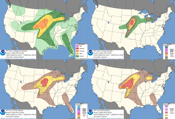
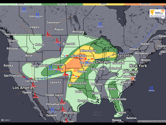
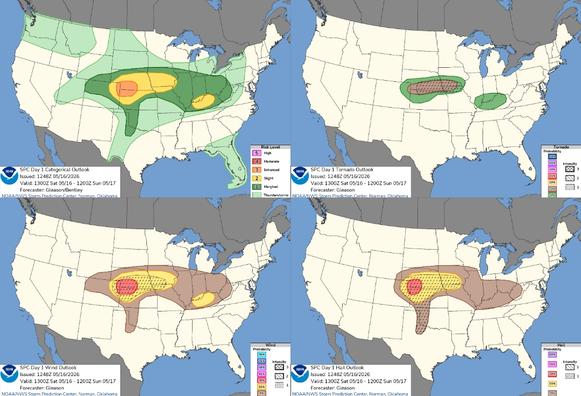
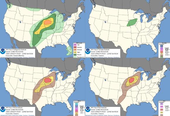
Organized thunderstorm activity is not anticipated today. #WeatherAwareDay #weather #wx #SPC #SevereWeather #categorical #tornado #wind #hail #TheOutPost Add'l info in alt text

Organized thunderstorm activity is not anticipated today.
#WeatherAwareDay #weather #wx #SPC #SevereWeather #categorical #tornado #wind #hail

Add'l info in alt text

Organized thunderstorm activity is not anticipated today.
#WeatherAwareDay #weather #wx #SPC #SevereWeather #categorical #tornado #wind #hail

Early Heat Wave in the West; Fire Concerns in the Plains
An anomalously early heat wave will continue to intensify and expand across the West and Southwest as the week progresses. Numerous daily and potentially monthly record highs are expected to be broken. Elevated to critical fire weather conditions are expected today across the High Plains and southern Plains. Lake effect snow downwind of the Great Lakes will taper off today.

#SevereWeather #VAwx #NCwx

7:42 pm EDT Screen capture of Omega Radar app show Radar KAKQ with one last line of storms lined up from Henderson NC to Charlottesville VA moving N/NE. Spotty showers follows the storm line.

#SevereWeather #CarolineCounty #Ladysmith

BakersRelay corner of Caroline County comes under the gun through 2:30 pm EDT. If I lose power please continue to follow
@easwatch
#VAwx
#NCwx
#MDwx
#DCwx

#SevereWeather #VAwx #NCwx #Norfolk #Chesapeake #ElizabethCity

1:33 pm EDT screen Capture of Radar Omega app NWS Wakefield Radar KAKQ showing heavy thunderstorms running N/NE from just past Elizabeth City NC through Williamsburg, VA. Blob of storms also passing Chesapeake, Northfolk, Virginia Beach VAwx

#SevereWeather #DEwx #MDwx #NJwx #PAwx

URGENT - IMMEDIATE BROADCAST REQUESTED
Tornado Watch Number 68
NWS Storm Prediction Center Norman OK
1130 AM EDT Mon Mar 16 2026

The NWS Storm Prediction Center has issued a

* Tornado Watch for portions of
Delaware
Eastern Maryland
New Jersey
Southeast Pennsylvania
Coastal Waters

* Effective this Monday morning and evening from 1130 AM until
700 PM EDT.

* Primary threats include...
A few tornadoes likely with a couple intense tornadoes possible
Widespread damaging winds and isolated significant gusts to 80
mph likely
Isolated large hail events to 1 inch in diameter possible

SUMMARY...Pre-frontal bands of storms will spread northeastward from
Virginia into southeast Pennsylvania through the afternoon, with an
attendant threat for swaths of damaging winds (60-80 mph) and a few
tornadoes with embedded circulations. A couple of strong tornadoes
(EF2) will be possible.

The tornado watch area is approximately along and 80 statute miles
east and west of a line from 50 miles northwest of Allentown PA to
35 miles west of Wilmington DE. For a complete depiction of the
watch see the associated watch outline update (WOUS64 KWNS WOU8)

#SevereWeather #VAwx #NCwx #MDwx #DCwx

URGENT - IMMEDIATE BROADCAST REQUESTED
Tornado Watch Number 67
NWS Storm Prediction Center Norman OK
1050 AM EDT Mon Mar 16 2026

The NWS Storm Prediction Center has issued a

* Tornado Watch for portions of
District Of Columbia
Maryland
Northeast North Carolina
Eastern Virginia
The eastern West Virginia Panhandle
Coastal Waters

* Effective this Monday morning and evening from 1050 AM until
700 PM EDT.

* Primary threats include...
A few tornadoes likely with a couple intense tornadoes possible
Widespread damaging winds and isolated significant gusts to 85
mph likely
Isolated large hail events to 1 inch in diameter possible

SUMMARY...Several bands and clusters of storms are expected to
intensify through the afternoon, with the potential to produce
swaths of damaging winds, some significant (75-85 mph), and embedded
circulations will pose a threat for several tornadoes, some of which
could be strong (EF2+).

The tornado watch area is approximately along and 70 statute miles
east and west of a line from 35 miles north of Baltimore MD to 55
miles west southwest of Norfolk VA. For a complete depiction of the
watch see the associated watch outline update (WOUS64 KWNS WOU7).

#SevereWeather #PAwx #NYwx

Mesoscale Discussion 0271
NWS Storm Prediction Center Norman OK
0957 AM CDT Mon Mar 16 2026

Areas affected...central Pennsylvania into far southern New York

Concerning...Severe potential...Watch possible

Valid 161457Z - 161630Z

Probability of Watch Issuance...60 percent

SUMMARY...A line of showers is likely to strengthen by late morning
into the early afternoon.

DISCUSSION...A line of showers has developed along a pre-frontal
trough across central Pennsylvania this morning. Based on SPC
mesoanalysis, it is currently in a very weakly unstable environment.
However, as it moves farther east, temperatures are warmer (mid 60s
F) with some low 60s dewpoints. As temperatures cool aloft, this
should result in greater instability through the late morning and
into the early afternoon.

Additional strengthening of this line and additional storm
development ahead of this line may result in some increase severe
weather threat. Damaging winds and perhaps a few tornadoes (given
the strong low-level shear), will be the primary threat.

As the intensity of this convection increases, a tornado watch may
be needed.

..Bentley/Thompson.. 03/16/2026