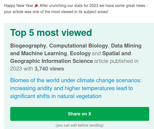
Our paper now published in Nature Scientific Data
"Global 30-m annual median vegetation height maps (2000–2022) based on ICESat-2 data and ML"
https://doi.org/10.1038/s41597-025-05739-6
Annual SVH data is available via: https://stac.openlandmap.org/gpw_gsvh-30m/collection.json?.language=en
View changes in SVH calculated on-the fly for 2000 to 2024: https://global-pasture-watch.projects.earthengine.app/view/gsvh-30m
Read more about why is these data important: https://landcarbonlab.org/insights/global-short-vegetation-height-outside-forest/
@earthmonitororg #OpenData #OpenLandMap

The session recordings from the Open-Earth Monitor Global Workshop 2024 are now available for watching via: https://www.youtube.com/playlist?list=PLXUoTpMa_9s3g9lD7_aP0XB12wluSPhRJ

📹 Over 20 hours of scientific content including keynote speeches, expert presentations, and demonstrative workshops covering geospatial applications, climate policies, biodiversity monitoring, and more. Workshop programme is at: https://earthmonitor.org/global-workshop-2024/

🌐 #ClimateAction #OpenEarthMonitor #GeospatialData #OpenData #OpenEO #OpenLandMap

Funded by @REA

Open Earth Monitor — Global Workshop 2024

YouTube
Our paper in PeerJ (https://doi.org/10.7717/peerj.15593) "Biomes of the world under climate change scenarios: increasing aridity and higher temperatures lead to significant shifts in natural vegetation" seems to be receiving a lot of interest (PeerJ just sent us stats). The data is available for download #OpenData via https://doi.org/10.5281/zenodo.7822868 and for viewing via #OpenLandMap
Biomes of the world under climate change scenarios: increasing aridity and higher temperatures lead to significant shifts in natural vegetation

The global potential distribution of biomes (natural vegetation) was modelled using 8,959 training points from the BIOME 6000 dataset and a stack of 72 environmental covariates representing terrain and the current climatic conditions based on historical long term averages (1979–2013). An ensemble machine learning model based on stacked regularization was used, with multinomial logistic regression as the meta-learner and spatial blocking (100 km) to deal with spatial autocorrelation of the training points. Results of spatial cross-validation for the BIOME 6000 classes show an overall accuracy of 0.67 and R2logloss of 0.61, with “tropical evergreen broadleaf forest” being the class with highest gain in predictive performances (R2logloss = 0.74) and “prostrate dwarf shrub tundra” the class with the lowest (R2logloss = −0.09) compared to the baseline. Temperature-related covariates were the most important predictors, with the mean diurnal range (BIO2) being shared by all the base-learners (i.e.,random forest, gradient boosted trees and generalized linear models). The model was next used to predict the distribution of future biomes for the periods 2040–2060 and 2061–2080 under three climate change scenarios (RCP 2.6, 4.5 and 8.5). Comparisons of predictions for the three epochs (present, 2040–2060 and 2061–2080) show that increasing aridity and higher temperatures will likely result in significant shifts in natural vegetation in the tropical area (shifts from tropical forests to savannas up to 1.7 ×10⁵ km2 by 2080) and around the Arctic Circle (shifts from tundra to boreal forests up to 2.4 ×10⁵ km2 by 2080). Projected global maps at 1 km spatial resolution are provided as probability and hard classes maps for BIOME 6000 classes and as hard classes maps for the IUCN classes (six aggregated classes). Uncertainty maps (prediction error) are also provided and should be used for careful interpretation of the future projections.

PeerJ

We have started reviewing all global environmental (published as open) data sets all at one place: https://openlandmap.github.io/book/compendium-of-global-gridded-environmental-data-sets.html

If you are aware of some relevant open global data set that we have maybe missed, please post here, or edit the document directly via Github. Thank you! #opendata #OpenEarthMonitor #OpenLandMap

3 Compendium of Global Gridded Environmental Data Sets | OpenLandMap Open Land Data services

This is an open compendium of global (gridded) environmental datasets (bio-geophysical variables). Here you can you find systematic reviews of published data sets (a selection of cutting-edge...

With the help of GILAB.rs and partners from the #OpenEarthMonitor project, we have just released V2 of the #OpenLandMap global data portal. It now runs on COGs and uses #STAC catalog to find and access information. We will spend next 12+ months adding TBs of #opendata at 30-100 m spatial resolution. Some exciting new datasets include global land cover 30-m GLC_FCS30D (1985-2022), monthly FAPAR, Sentinel-5P monthly tropospheric nitrogen dioxide density... https://www.youtube.com/watch?v=lPiS8iVelhI
OpenLandMap V2 in action

YouTube

🗓 This year, the #OEMCGW will host a variety of formats, from keynote lectures to oral talks, workshops, and poster presentations! Register for online or in-person participation using the link below.

👩‍💻👨‍💻20+ workshops on #ARCO #OpenLandMap #GEOSS #xcube #GEO #GreenDeal #DigitalTwin #OpenEO #FAIR #EcoDataCube #datacube

https://earthmonitor.org/gw2023/

Global Workshop 2023 – Open-Earth-Monitor project

We are testing using global compilations of soil profiles and HWSDv2 for predicting soil types (WRB classification system). You can access all inputs and outputs here: https://github.com/OpenGeoHub/SoilTypeMapping

If you are aware of some important soil profile dataset we missed, please let us know. #opendata #OpenLandMap

GitHub - OpenGeoHub/SoilTypeMapping: Predictive soil mapping aiming at making complete consistent soil type maps of the world

Predictive soil mapping aiming at making complete consistent soil type maps of the world - GitHub - OpenGeoHub/SoilTypeMapping: Predictive soil mapping aiming at making complete consistent soil typ...

GitHub
Growth of Istanbul and Doha from 2000 to 2021 on Visible Light at Night images (500 m spatial resolution). The dataset is at: https://doi.org/10.5281/zenodo.7750174 #OpenLandMap #OpenEarthMonitor
Annual time series of global VIIRS nighttime lights for 2000-2021 at 500-m spatial resolution extrapolated using logistic regression

The Annual Visible Night Light (VNL) V2 (VIIRS) images at 500-m spatial resolution for the period 2012 to 2021 (Elvidge et al., 2021) have been used to extrapolate the values backwards for years 2000–2011. This was done by fitting a logistic regression (per pixel) and then predicting the values for the previous years (see nightlights_stack_500m.R). After consistent time-series have been produced, I also derived the difference between average of the years 2020/2021 and years 2000/2021 (nightlights.difference_viirs.v21_m_500m_s_2000_2021_go_epsg4326_v20230318.tif): this shows average rate of change for the 22 years period. Use with caution: extrapolation of values can lead to artifacts. For most of the land surface, however, it appears that the growth of night lights follows exponential growth function and hence nights in the past can be represented accurately by fitting decay / logistic regression function. Original values from the Annual VNL V2 product have been converted from 0–200 to 0–2000 scale and are available as Cloud-Optimized GeoTIFFs. To cite the Annual VNL V2, please use: Elvidge, C. D., Zhizhin, M., Ghosh, T., Hsu, F. C., & Taneja, J. (2021). Annual time series of global VIIRS nighttime lights derived from monthly averages: 2012 to 2019. Remote Sensing, 13(5), 922. https://doi.org/10.3390/rs13050922 Historic night light images are also available (but at a much coarser spatial resolution) from: Li, X., Zhou, Y., Zhao, M., & Zhao, X. (2020). A harmonized global nighttime light dataset 1992–2018. Scientific data, 7(1), 168. https://doi.org/10.1038/s41597-020-0510-y

Zenodo
A compilation of analysis-ready point data for the purpose of vegetation and Potential Natural Vegetation mapping for the #EU https://gitlab.com/openlandmap/eu-forest-tree-point-data #openlandmap @opengeohub #openscience #climatechange #reforestation #climate #sustainability
OpenLandMap / EU forest tree point data

A compilation of analysis-ready point data for the purpose of vegetation and Potential Natural Vegetation mapping (EU coverage only)

GitLab
#OpenLandMap son datos (masa terrestre global), servicios y aplicaciones web que proporcionan acceso y visualizaciones interactivas de alta resolución (1 km, 250 m o mejor) producidos por la Fundación #OpenGeoHub y organizaciones colaboradoras.
#OpenData #Maps #ODbL #CreativeCommons #GIS
https://openlandmap.org
OpenLandMap

Web site created using create-react-app