#BIS #NDwx Sorry, product text is unavailable. https://www.wpc.ncep.noaa.gov/qpf/excessive_rainfall_outlook_ero.php
#BIS #NDwx 395
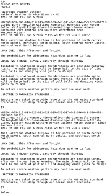
NOUS43 KBIS 052009
PNSBIS
NDZ001>005-009-010-012-013-017>020-022-023-025-031>033-035>037-
040>044-046>048-050-051-055>062-072015-
Public Information Statement
National Weather Service Bismarck ND
309 PM CDT Fri Jun 5 2026 /209 PM MDT Fri Jun 5 2026/
...THE MINOT WEATHER RADAR WILL UNDERGO MAINTENANCE BEGINNING
MONDAY, JUNE 8TH...
The Minot Doppler weather radar, KMBX, will be out of service
early next week for maintenance. This includes installation https://mesonet.agron.iastate.edu/p.php?pid=202606052009-KBIS-NOUS43-PNSBIS