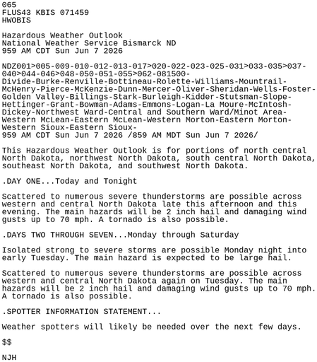
#BIS #NDwx 596
WWUS73 KBIS 071801
NPWBIS

URGENT - WEATHER MESSAGE
National Weather Service Bismarck ND
101 PM CDT Sun Jun 7 2026

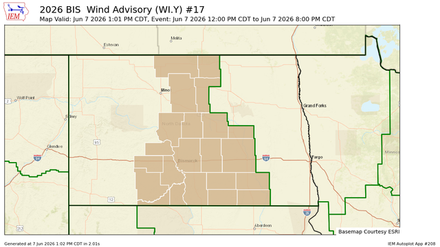
NDZ004-005-012-013-020-022-023-025-035>037-042-046>048-050-051-
058>062-080100-
/O.CON.KBIS.WI.Y.0017.000000T0000Z-260608T0100Z/
Bottineau-Rolette-McHenry-Pierce-Oliver-Sheridan-Wells-Foster-
Burleigh-Kidder-Stutsman-Grant-Emmons-Logan-La Moure-McIntosh-Dickey-
Eastern McLean-Western Morton-Eastern Morton-Western Sioux-
Eastern Sioux-
Inclu https://mesonet.agron.iastate.edu/vtec/f/2026-O-CON-KBIS-WI-Y-0017_2026-06-07T18:01Z

KBIS Wind Advisory #17

Bottineau, Rolette, McHenry, Pierce, Dickey, Eastern McLean, Western Morton, Eastern Morton, Western Sioux, Eastern Sioux, Oliver, Sheridan, Wells, Foster, Burleigh, Kidder, Stutsman, Grant, Emmons, Logan, La Moure, McIntosh

Iowa Environmental Mesonet

#BIS #NDwx 699
FXUS63 KBIS 071758
AFDBIS

Area Forecast Discussion
National Weather Service Bismarck ND
1258 PM CDT Sun Jun 7 2026

.KEY MESSAGES...

- Scattered to numerous severe thunderstorms over much of
western and central North Dakota late this afternoon and
tonight.

- Another round of scattered to numerous severe thunderstorms is
possible on Tuesday.

- Above normal temperatures through Tuesday, then trending
cooler for the remainder of the week.

&&

https://mesonet.agron.iastate.edu/p.php?pid=202606071758-KBIS-FXUS63-AFDBIS

IEM :: AFD from NWS BIS

AFD issued by NWS BIS at 07 Jun 2026 17:58 UTC

#BIS #NDwx 367
FLUS43 KBIS 071738
HWOBIS

Hazardous Weather Outlook
National Weather Service Bismarck ND
1238 PM CDT Sun Jun 7 2026

NDZ001>005-009-010-012-013-017>020-022-023-025-031>033-035>037-
040>044-046>048-050-051-055>062-081745-
Divide-Burke-Renville-Bottineau-Rolette-Williams-Mountrail-
McHenry-Pierce-McKenzie-Dunn-Mercer-Oliver-Sheridan-Wells-Foster-
Golden Valley-Billings-Stark-Burleigh-Kidder-Stutsman-Slope-
Hettinger-Grant-Bowman-Adams-Emmons-Logan-La Mour https://mesonet.agron.iastate.edu/p.php?pid=202606071738-KBIS-FLUS43-HWOBIS

IEM :: HWO from NWS BIS

HWO issued by NWS BIS at 07 Jun 2026 17:38 UTC

#BIS #NDwx 294
WUUS02 KWNS 071734
PTSDY2

DAY 2 CONVECTIVE OUTLOOK AREAL OUTLINE
NWS STORM PREDICTION CENTER NORMAN OK
1232 PM CDT SUN JUN 07 2026

VALID TIME 081200Z - 091200Z

PROBABILISTIC OUTLOOK POINTS DAY 2

... TORNADO ...

0.02 40280169 39820224 39760372 40070437 40980476 41770475
41910426 41400178 40280169
&&

... HAIL ...

0.05 41850539 42520513 43270585 43640519 43730393 43250207
42620140 42470024 42839931 44209840 45079776 47199589
https://www.spc.noaa.gov/products/outlook/archive/2026/day2otlk_20260607_1730.html

#BIS #NDwx 601
WUUS01 KWNS 071641
PTSDY1

DAY 1 CONVECTIVE OUTLOOK AREAL OUTLINE
NWS STORM PREDICTION CENTER NORMAN OK
1139 AM CDT SUN JUN 07 2026

VALID TIME 071630Z - 081200Z

PROBABILISTIC OUTLOOK POINTS DAY 1

... TORNADO ...

0.02 49549954 48409986 46830054 45970124 45270194 44570326
44470437 44640515 45650537 46430518 47460358 48520330
49460340
0.02 34209514 34399571 34959640 36229702 37019693 38409491
38919357 38419239 37839180 37029156 https://www.spc.noaa.gov/products/outlook/archive/2026/day1otlk_20260607_1630.html

#BIS #NDwx 992
FXUS63 KBIS 071508
AFDBIS

Area Forecast Discussion
National Weather Service Bismarck ND
1008 AM CDT Sun Jun 7 2026

.KEY MESSAGES...

- Scattered to numerous severe thunderstorms over much of
western and central North Dakota late this afternoon and
tonight.

- Another round of scattered to numerous severe thunderstorms is
possible on Tuesday.

- Above normal temperatures through Tuesday, then trending
cooler for the remainder of the week.

&&
https://mesonet.agron.iastate.edu/p.php?pid=202606071508-KBIS-FXUS63-AFDBIS

IEM :: AFD from NWS BIS

AFD issued by NWS BIS at 07 Jun 2026 15:08 UTC

#BIS #NDwx 065
FLUS43 KBIS 071459
HWOBIS

Hazardous Weather Outlook
National Weather Service Bismarck ND
959 AM CDT Sun Jun 7 2026

NDZ001>005-009-010-012-013-017>020-022-023-025-031>033-035>037-
040>044-046>048-050-051-055>062-081500-
Divide-Burke-Renville-Bottineau-Rolette-Williams-Mountrail-
McHenry-Pierce-McKenzie-Dunn-Mercer-Oliver-Sheridan-Wells-Foster-
Golden Valley-Billings-Stark-Burleigh-Kidder-Stutsman-Slope-
Hettinger-Grant-Bowman-Adams-Emmons-Logan-La Moure https://mesonet.agron.iastate.edu/p.php?pid=202606071459-KBIS-FLUS43-HWOBIS

IEM :: HWO from NWS BIS

HWO issued by NWS BIS at 07 Jun 2026 14:59 UTC

#BIS #NDwx 540
FLUS43 KBIS 071212
HWOBIS

Hazardous Weather Outlook
National Weather Service Bismarck ND
712 AM CDT Sun Jun 7 2026

NDZ001>005-009-010-012-013-017>020-022-023-025-031>033-035>037-
040>044-046>048-050-051-055>062-081215-
Divide-Burke-Renville-Bottineau-Rolette-Williams-Mountrail-
McHenry-Pierce-McKenzie-Dunn-Mercer-Oliver-Sheridan-Wells-Foster-
Golden Valley-Billings-Stark-Burleigh-Kidder-Stutsman-Slope-
Hettinger-Grant-Bowman-Adams-Emmons-Logan-La Moure https://mesonet.agron.iastate.edu/p.php?pid=202606071212-KBIS-FLUS43-HWOBIS

IEM :: HWO from NWS BIS

HWO issued by NWS BIS at 07 Jun 2026 12:12 UTC

#BIS #NDwx 989
WUUS01 KWNS 071206
PTSDY1

DAY 1 CONVECTIVE OUTLOOK AREAL OUTLINE
NWS STORM PREDICTION CENTER NORMAN OK
0704 AM CDT SUN JUN 07 2026

VALID TIME 071300Z - 081200Z

PROBABILISTIC OUTLOOK POINTS DAY 1

... TORNADO ...

0.02 34399457 34519531 34979602 36049631 36879623 37529583
38409487 38639392 38259255 37589197 37349190 36769180
35719203 35029243 34709277 34439371 34399457
0.02 49549954 48409986 46830054 45970124 45270194 44570326
https://www.spc.noaa.gov/products/outlook/archive/2026/day1otlk_20260607_1300.html

#BIS #NDwx 156
FXUS63 KBIS 071201
AFDBIS

Area Forecast Discussion
National Weather Service Bismarck ND
701 AM CDT Sun Jun 7 2026

.KEY MESSAGES...

- Scattered to numerous severe thunderstorms over much of
western and central North Dakota late this afternoon and
tonight.

- Another round of scattered to numerous severe thunderstorms is
possible on Tuesday.

&&

.UPDATE...
Issued at 641 AM CDT Sun Jun 7 2026

Mainly just some minor updates for pops early this mo https://mesonet.agron.iastate.edu/p.php?pid=202606071201-KBIS-FXUS63-AFDBIS

IEM :: AFD from NWS BIS

AFD issued by NWS BIS at 07 Jun 2026 12:01 UTC