Flood breaches Green River levee in Tukwila, evacuation area includes both Green River and Interurban South Trails

Screenshot from King County Sheriff helicopter footage.

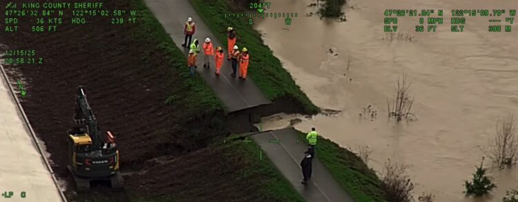
The Desimone Levee has failed between S 180th and 190s Streets, triggering an emergency “GO NOW” evacuation order from King County. UPDATE 10pm: The area under the GO NOW order has been significantly reduced since the initial alert, and a stretch from the Green River to SR-167 that includes both the Interurban South and Green River Trails is under a flood alert. King County has an emergency alert map that shows exact areas under active alerts.

As KIRO 7 reported, emergency crews have so far contained flood waters to a relatively small area within a block or two of the breach, but more rain is in the forecast.

The Green River Trail sits on top of the breached levee, and footage of the breach shows a section of the trail completely missing. So needless to say, the Green River Trail is closed and will likely remain closed even after this flood event.

Do not attempt to bike through flood water even if the level is low. Not only can flows be stronger than they appear, but flood water contains sewage and other nasty industrial stuff that you don’t want to deal with.

There is no easy detour if both trails are closed. Military Road is probably the best alternative bike route between Kent and South Park that avoids the evacuation zone (from South Park: Des Moines Memorial – Military Road – S 152nd Street – 42nd Ave S – Military Road). It has painted bike lanes or decent shoulders much of the way around the flood area, but it is not a comparable experience to biking on a trail. Another option is to take your bike on the light rail, which now has stations at Kent Des Moines, Star Lake and Federal Way.

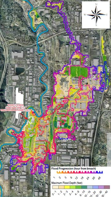
This map below from King County shows the initial emergency area, which is also a map of areas that could be at risk if flooding significantly worsens and the levee fails completely. So if you are in this area but not in the smaller GO NOW area, be on alert.

Evacuation map from King County.

#SEAbikes #Seattle

Floods close some roads and trails near Green, Snoqualmie Rivers + Many area rivers are in flood stages

The huge amount of rainfall across the region in recent days has sent several rivers into flood stages, including the Cedar, Green, Snoqualmie, South Fork Skykomish, Tolt and White Rivers as well as Issaquah Creek. Get updated information on the flooding from the King County Flood Warning Center, and track road closures via King County’s My Commute map. There is also some significant flooding in Pierce County. I would avoid much of the Foothills Trail due to flooding on several waterways including the trail-adjacent South Prairie Creek.

Though these maps doesn’t show trail closures, it’s likely that trails near closed roadways would also be closed. If nothing else, it’s best to stay away from flooding areas in general. The Snoqualmie River valley between Carnation and Fall City and the Green River valley between Auburn and Black Diamond are especially hard hit at the time of writing.

Though it is not listed on that map, the Green River Trail is closed through Fort Dent Park in Tukwila as the river is projected to reach Phase 3 flooding due to the huge amount of rainfall across the region in recent days, according to an email from the King County Department of Natural Resources (thanks for the tip Lee Lambert!). It’s possible users will still be able to cross the river and connect to the Lake to Sound Trail or get to Starfire Way via the northeast parking lot (King County should consider leaving open the northeast gate between the parking lot and the trails), but I wouldn’t count on it. It’s really best to avoid the area. Nearby Interurban Ave S does have a sidewalk between Fort Dent Way and Riverside Casino, so that’s probably a better option. If heading south, just don’t turn after the casino, continuing on the sidewalk instead. You’ll eventually reach Fort Dent Way, and the trail will be right there.

Map from King County DNR.

It is definitely possible that other sections of the Green River Trail and other riverside trails will also be flooded. Please do not attempt to bike through flood water. Not only can the currents be stronger than you expect, but flood water can be really nasty and contain sewage or industrial grossness. It’s not worth it.

If you encounter any flooded trails, let us know by emailing [email protected] or commenting below. Stay safe out there.

#SEAbikes #Seattle

/2 As a followup to the Lake to Sound Trail Segment C project, I am leading a free group ride as part of a trail opening celebration event in partnership with King County Parks and Leafline Trails Coalition this Saturday:

https://cascade.org/rides-events/86767

#seattle #pnw #SEAbikes #BikeTooter #seatac #burien #whiteCenter #tukwila #renton #greenRiverTrail #LakeToSoundTrail

Lake to Sound Trail Segment C - Trail Opening Celebration Tour (Leisurely) | Cascade Bicycle Club

Cascade Bicycle Club

Learn about 4 different bike infrastructure projects happening just south of Seattle in my latest video guide! There’s a lot to look forward to, and I tried to visualize how some of the projects may turn out.

Check it out:
https://youtu.be/JiAgvLeThGU?si=FwFWhH5tJCDOea3w
#seattle #pnw #SEAbikes #BikeTooter #seatac #burien #whiteCenter #tukwila #renton #greenRiverTrail #LakeToSoundTrail

South of Seattle Bike Projects Guide (2025)

YouTube

Alert 4/8–Summer: Green River Trail construction west of the Tukwila Urban Center Bridge

https://www.seattlebikeblog.com/2024/04/02/alert-4-8-summer-green-river-trail-construction-west-of-the-tukwila-urban-center-bridge/

#SEAbikes #Seattle

Alert 4/8–Summer: Green River Trail construction west of the Tukwila Urban Center Bridge

Whether you’re headed across the river or continuing on the trail, you can do better than the official detour. A 700-foot section of the Green River Trail is getting repaved and upgraded in T…

Seattle Bike Blog