#Entwarnung
an meine Hamburger Bubble:
Keine Gefahr durch Gas mehr.
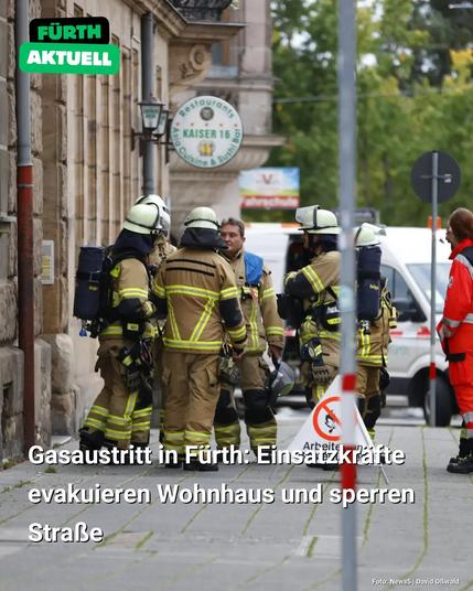
Gasaustritt in Fürth: Einsatzkräfte evakuieren Wohnhaus und sperren Straße
Link zum Online-Artikel: https://fuerthaktuell.de/?p=6877
#fürth #gasaustritt #gasleck #evakuierung #feuerwehr #polizei #energieversorger #kaiserstrasse #sperrung #belüftung #franken #mittelfranken #bayern #news
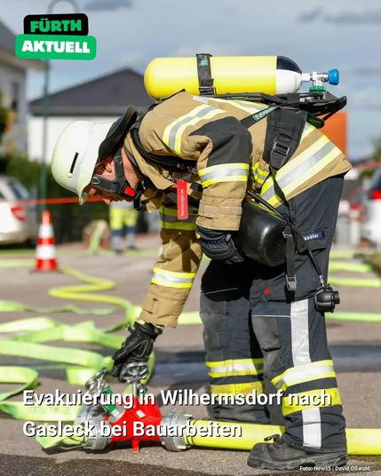
Evakuierung in Wilhermsdorf nach Gasleck bei Bauarbeiten
https://fuerthaktuell.de/?p=6071
#wilhermsdorf #landkreisfürth #evakuierung #gasleck #gasnetz #gasschieber #feuerwehr #einsatzkraefte #bayerischesroteskreuz #sicherung #franken #mittelfranken #bayern #news
Siebenköpfige Familie durch Gasaustritt vergiftet https://www.diebayern.de/unfall/siebenkoepfige-familie-durch-gasaustritt-vergiftet-2996606?utm_source=Mastodon&utm_medium=dpa&utm_content=textlink #Notfall #OBERPFALZ #Bayern #Gasleck #Feuerwehr #NeumarktinderOberpfalz

Gasleck im Harburger Hafen – Bahnverkehr kurz unterbrochen
https://bahnblogstelle.com/220380/gasleck-im-harburger-hafen-bahnverkehr-unterbrochen/
#Gasleck #Hamburg #Harburg #Hafen #Bahnverkehr #Güterzug #Kesselwagen #Feuerwehr #Polizei

#Satelliten helfen uns, #Methan-Lecks zu finden und zu stoppen! #Methan ist viel schädlicher für unser #Klima als CO2. #Satellitenbilder von #GHGSat lassen ein aktives #Gasleck in Großbritannien genau erkennen. Die Satellitendaten stimmen mit Messungen am Boden übereinstimmen. Das hilft, Lecks schneller zu finden und zu reparieren, um unseren Planeten zu schützen.
#Klimaschutz #Umwelt #Technologie
#DOI: 10.5194/amt-17-1599-2024

First validation of high-resolution satellite-derived methane emissions from an active gas leak in the UK
Abstract. Atmospheric methane (CH4) is the second-most-important anthropogenic greenhouse gas and has a 20-year global warming potential 82 times greater than carbon dioxide (CO2). Anthropogenic sources account for ∼ 60 % of global CH4 emissions, of which 20 % come from oil and gas exploration, production and distribution. High-resolution satellite-based imaging spectrometers are becoming important tools for detecting and monitoring CH4 point source emissions, aiding mitigation. However, validation of these satellite measurements, such as those from the commercial GHGSat satellite constellation, has so far not been documented for active leaks. Here we present the monitoring and quantification, by GHGSat's satellites, of the CH4 emissions from an active gas leak from a downstream natural gas distribution pipeline near Cheltenham, UK, in the spring and summer of 2023 and provide the first validation of the satellite-derived emission estimates using surface-based mobile greenhouse gas surveys. We also use a Lagrangian transport model, the UK Met Office's Numerical Atmospheric-dispersion Modelling Environment (NAME), to estimate the flux from both satellite- and ground-based observation methods and assess the leak's contribution to observed concentrations at a local tall tower site (30 km away). We find GHGSat's emission estimates to be in broad agreement with those made from the in situ measurements. During the study period (March–June 2023) GHGSat's emission estimates are 236–1357 kg CH4 h−1, whereas the mobile surface measurements are 634–846 kg CH4 h−1. The large variability is likely down to variations in flow through the pipe and engineering works across the 11-week period. Modelled flux estimates in NAME are 181–1243 kg CH4 h−1, which are lower than the satellite- and mobile-survey-derived fluxes but are within the uncertainty. After detecting the leak in March 2023, the local utility company was contacted, and the leak was fixed by mid-June 2023. Our results demonstrate that GHGSat's observations can produce flux estimates that broadly agree with surface-based mobile measurements. Validating the accuracy of the information provided by targeted, high-resolution satellite monitoring shows how it can play an important role in identifying emission sources, including unplanned fugitive releases that are inherently challenging to identify, track, and estimate their impact and duration. Rapid, widespread access to such data to inform local action to address fugitive emission sources across the oil and gas supply chain could play a significant role in reducing anthropogenic contributions to climate change.
Gasleitung wird bei Bauarbeiten in Hamburg beschädigt
Bei Arbeiten in Hamburg-Schnelsen hat ein Bagger die Leitung getroffen. Viele Einsatzkräfte waren mehrere Stunden vor Ort.
#hamburg #Schnelsen #Gasleitung #Bagger #Feuerwehr #Gasleck #HamburgNews #Hamburg

Spekulationen über die #gasblase
#gasleck #Pipeline
Da bin ich dabei dabei 😉
https://bullauge-blog.de/2022/09/30/gasblase/
#gasleck #Pipeline
Da bin ich dabei dabei 😉
https://bullauge-blog.de/2022/09/30/gasblase/
