Do AI tools undermine trust in geospatial imagery?
https://fed.brid.gy/r/https://spacenews.com/do-ai-tools-undermine-trust-in-geospatial-imagery/
Do AI tools undermine trust in geospatial imagery?
https://fed.brid.gy/r/https://spacenews.com/do-ai-tools-undermine-trust-in-geospatial-imagery/
Posted by Vantor on Linkedin
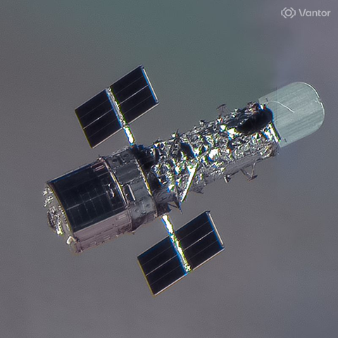
"Collected on April 23, 2026, by one of Vantor's WorldView Legion satellites, this remarkable non-Earth image showcases Hubble from just 61.8 km away—an incredible perspective of one of humanity’s most iconic scientific instruments. With a space sample distance of 4.0 cm"
Countering missile threats ‘left of launch’
https://fed.brid.gy/r/https://spacenews.com/countering-missile-threats-left-of-launch/
Earth observation operators push to deliver satellite images within minutes
"...historical imagery over areas where US, NATO, & other allied & partner forces are actively operating, as well as over areas that are being actively targeted by adversaries,” Tomi Maxted, a #Vantor spox emailed."
"These decisions are not mandated by any govt, military organization, or third party.”
Well
And there you are: gave away the whole deal right there...
#Iran #IranWar #WorldWarIII #DonaldTrump #PeteHegseth #BenjaminNetanyahu
“These controls can include limiting who is able to task new imagery or purchase historical imagery over areas where US, NATO, & other allied & partner forces are actively operating, as well as over areas that are being actively targeted by adversaries,” Tomi Maxted, a #Vantor spox emailed.
“Vantor independently determines when & how these controls are implemented as part of our responsible business practices. These decisions are not mandated by any govt, military organization, or third party.”
#Satellite companies restrict access to #MiddleEast imagery amid #Iran #war
2 leading spatial #intelligence companies say they are restricting access to satellite images of the Middle East in response to the #US - #Israel war with Iran.
#PlanetLabs & #Vantor, which are based in the #UnitedStates & have #federal contracts, say they were not “ordered” by any #government to restrict image #access.
#law #information #censorship #Trump #geopolitics
https://www.washingtonpost.com/national-security/2026/03/11/satellite-images-middle-east-iran/
Vantor partners with Google AI to automate intelligence reports for government agencies