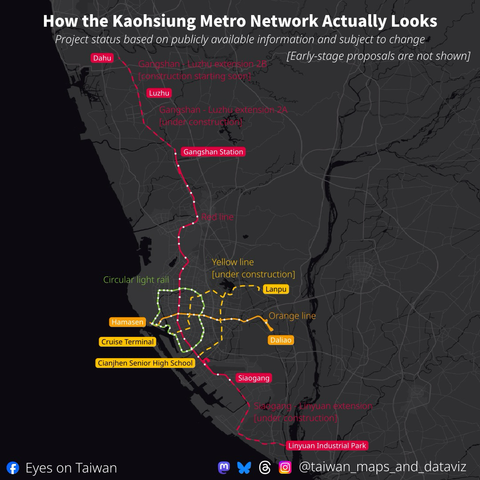
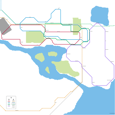
sketching out ideas for multi-modal transit map of the Lisbon Metro Area. alas, lacking any actual design abilities means they'll be stuck as thoughts in my head and scribbles on my page
@c_9 TTC “Subway and Light Rail” maps now up on the Line 1 Downsview Park subway station platform pillars/walls
Line 6 and Line 5, represent.
| #TTC #DownsviewPark #NorthYork #Toronto #Wayfinding #TransitMaps #PublicTransit #TOpoli
Two new stations on the Link 2 Line opened over the weekend.
I created these two spider maps for King County Metro--they show the bus line connections to and from the new stations.
New subway map seen in the wild.
I made a metro/train nap for my cities skylines 2 save using Metromapmaker :3
The downtown #Seattle frequent service map for the spring service change is the same as the map from the fall '24 service change.
The spider map for University of Washington Station, Seattle.
Spider maps are transit maps that show routes serving a specific place. The routes radiate out from that place—sorta like the legs of a spider.
More at
https://conspiracyofcartographers.com/transit-map-gallery/
The spider map for Capitol Hill Station, Seattle.
Spider maps are transit maps that show routes serving a specific place. The routes radiate out from that place—sorta like the legs of a spider.