MFR issues Area Forecast Discussion (AFD) at Jun 12, 2:00 PM PDT
https://mesonet.agron.iastate.edu/p.php?pid=202606122100-KMFR-FXUS66-AFDMFR
MFR issues Area Forecast Discussion (AFD) at Jun 12, 2:00 PM PDT
https://mesonet.agron.iastate.edu/p.php?pid=202606122100-KMFR-FXUS66-AFDMFR
MFR issues Area Forecast Discussion (AFD) at Jun 12, 10:48 AM PDT
https://mesonet.agron.iastate.edu/p.php?pid=202606121748-KMFR-FXUS66-AFDMFR
PQR issues Area Forecast Discussion (AFD) at Jun 12, 10:42 AM PDT
https://mesonet.agron.iastate.edu/p.php?pid=202606121742-KPQR-FXUS66-AFDPQR
PQR continues Heat Advisory valid at Jun 14, 11:00 AM PDT for 17 forecast zones in [OR] and Central Columbia River Gorge - SR 14, Cowlitz County Lowlands, North Clark County Lowlands, South Washington Cascade Foothills, Willapa Hills, Willapa and Wahkiakum Lowlands [WA] till Jun 16, 11:00 PM PDT
https://mesonet.agron.iastate.edu/vtec/f/2026-O-CON-KPQR-HT-Y-0002_2026-06-14T18:00Z
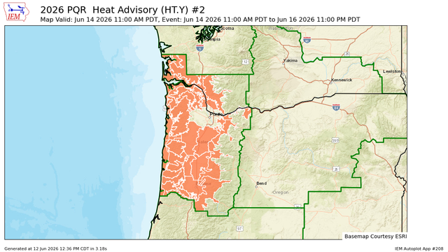
Lower Columbia River, Outer Southeast Portland Metro, West Central Willamette Valley, East Central Willamette Valley, North Oregon Coast Range Lowlands, Central Oregon Coast Range Lowlands, North Oregon Coast Range, Lane County Cascade Foothills, Willapa and Wahkiakum Lowlands, Willapa Hills, Cowlitz County Lowlands, Clatsop County Coast, Tillamook County Coast, Central Coast of Oregon, South Washington Coast, Central Oregon Coast Range, Benton County Lowlands, Linn County Lowlands, Lane County Lowlands, West Columbia River Gorge of Oregon above 500 ft, Upper Hood River Valley, Central Columbia River Gorge I-84 Corridor, Clackamas County Cascade Foothills, Cascade Foothills of Marion and Linn Counties, North Clark County Lowlands, South Washington Cascade Foothills, Central Columbia River Gorge - SR 14
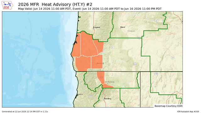
MFR issues Heat Advisory valid at Jun 14, 11:00 AM PDT for Central Siskiyou County, South Central Siskiyou County [CA] till Jun 16, 11:00 PM PDT
https://mesonet.agron.iastate.edu/vtec/f/2026-O-NEW-KMFR-HT-Y-0002_2026-06-14T18:00Z
ORZ109-122200-
Tualatin Valley
742 AM PDT Fri Jun 12 2026
...EXTREME HEAT WARNING IN EFFECT FROM 11 AM SUNDAY TO 11 PM PDT
TUESDAY...
.TODAY...Sunny. Highs in the lower 80s. North wind 5 to 10 mph.
.TONIGHT...Clear. Lows in the mid 50s. Northwest wind 5 to
10 mph.
.SATURDAY...Sunny. Highs in the mid 90s. North wind 5 to 10 mph.
.SATURDAY NIGHT...Clear. Lows in the lower 60s. North wind 5 to
10 mph.
#orwx #tualatin #tualatinvalley #washingtoncountyor #pdx #heatwave
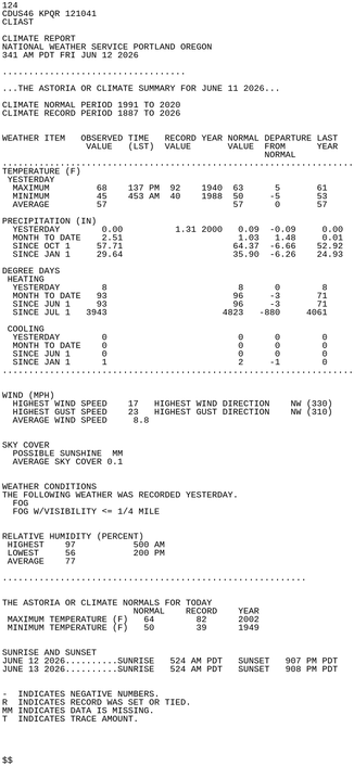
ASTORIA OR Jun 11 Climate Report: High: 68 Low: 45 Precip: 0.0" Snow: Missing
https://mesonet.agron.iastate.edu/p.php?pid=202606121041-KPQR-CDUS46-CLIAST
PQR issues Area Forecast Discussion (AFD) at Jun 12, 3:27 AM PDT
https://mesonet.agron.iastate.edu/p.php?pid=202606121027-KPQR-FXUS66-AFDPQR
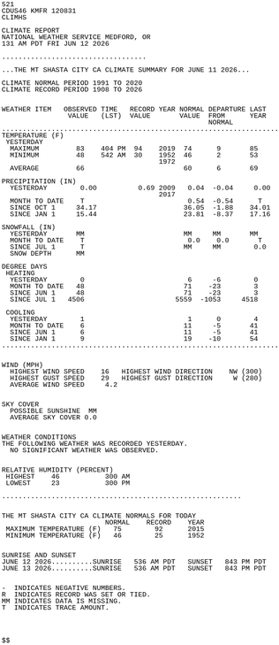
MT SHASTA CITY CA Jun 11 Climate Report: High: 83 Low: 48 Precip: 0.0" Snow: Missing
https://mesonet.agron.iastate.edu/p.php?pid=202606120831-KMFR-CDUS46-CLIMHS
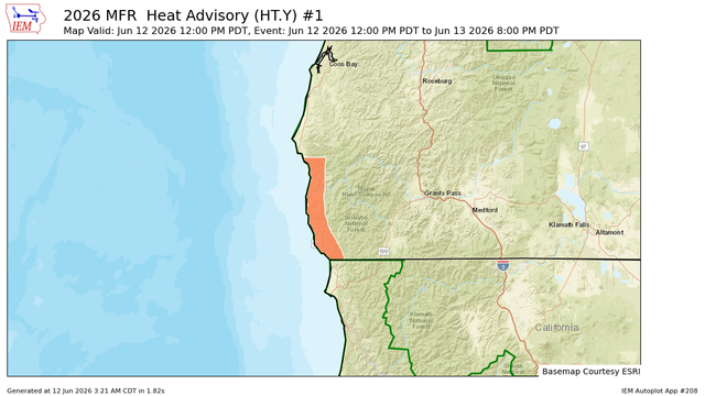
MFR continues Heat Advisory valid at Jun 12, 12:00 PM PDT for Curry County Coast [OR] till Jun 13, 8:00 PM PDT
https://mesonet.agron.iastate.edu/vtec/f/2026-O-CON-KMFR-HT-Y-0001_2026-06-12T19:00Z