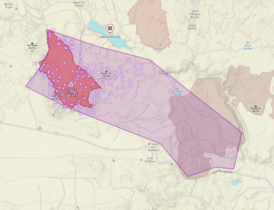
I was hesitant to release my estimated perimeter of the #CowValleyFire near Brogan, OR (just across Idaho/Oregon line)

But Malheur Sheriff confirms the fire is burning rapidly east and has crossed the highway to wards the south. Brogan, OR is at risk.

I've attached a map of the (red) official last mapped perimeter, with my very rough estimate based on what I see. and it'd be 20k+ acres. Hell of a fire given the amount of retardant that has been dropped today.

#IdahoFire #OregonFire

#IdahoFire #OregonFire

11pm (mountain) GOES-West look at the fires just across the Oregon border shows the River Fire at Owyhee reservoir appears to be bedding down a bit. However the Huntington fire is still quite energetic. Evacuation orders are in place for both fires.

#Umatilla County #Oregon: Level 3 - GO NOW for #wildfire N of Bensel/Progress Rd, E of Bud Draper Rd, salmon point. #EVACUATE #fire #OR #OregonFire
#Spokane #WA seems to be very flammable, two major wildfires with evacuations last night. #OregonFire #GrayFire #wildfires https://app.watchduty.org/
Watch Duty - Wildfire Maps & Alerts

Real-time information about wildfire and firefighting efforts nearby

Watch Duty
Facebook

Some pretty intense smoke flying out of #pdx this morning.

#everythingisonfire #pdxfire #oregonfire