MPX issues Area Forecast Discussion (AFD) at Jun 1, 6:15 PM CDT
https://mesonet.agron.iastate.edu/p.php?pid=202606012315-KMPX-FXUS63-AFDMPX
MPX issues Area Forecast Discussion (AFD) at Jun 1, 6:15 PM CDT
https://mesonet.agron.iastate.edu/p.php?pid=202606012315-KMPX-FXUS63-AFDMPX
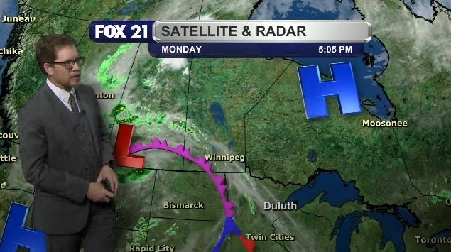
NORTHLAND FORECAST FOR JUNE 2, 2026:
A new high-pressure system to our north will #clear out #cloud cover across the #Northland Monday night, helping to #cool low #temperatures to the 40s.
The #sunshine will persist Tuesday as the lake #breeze becomes very light. That will help #warm most highs to the 70s and 80s, with the 60s only along the #LakeSuperior shoreline.
VIDEO/DISCUSSION: fox21online.com/weather
#DLH #MNwx 662
FXUS63 KDLH 012159
AFDDLH
Area Forecast Discussion
National Weather Service Duluth MN
459 PM CDT Mon Jun 1 2026
.KEY MESSAGES...
- Mostly hot and dry today through at least mid day Wednesday.
Cooler near Lake Superior. Near critical fire weather in
northern MN through this evening.
- More widespread near critical fire weather on Tuesday, then
possible on Wednesday for both far northern MN and northwest
Wisconsin.
- Gusty northeast winds at https://mesonet.agron.iastate.edu/p.php?pid=202606012159-KDLH-FXUS63-AFDDLH
#DLH #MNwx 751
FLUS43 KDLH 012152
HWODLH
Hazardous Weather Outlook
National Weather Service Duluth MN
452 PM CDT Mon Jun 1 2026
MNZ010>012-018>021-025-026-033>038-WIZ001>004-006>009-022200-
Koochiching-North St. Louis-Northern Cook/Northern Lake-
North Itasca-Central St. Louis-Southern Lake/North Shore-
Southern Cook/North Shore-North Cass-South Itasca-South Cass-
Crow Wing-Northern Aitkin-South Aitkin-Carlton/South St. Louis-
Pine-Douglas-Bayfield-Ashland-Iron-Burne https://mesonet.agron.iastate.edu/p.php?pid=202606012152-KDLH-FLUS43-HWODLH
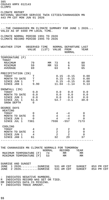
CHANHASSEN MN Jun 1 Climate Report: High: 79 Low: 59 Precip: Trace Snow: 0.0" Snow Depth: 0"
https://mesonet.agron.iastate.edu/p.php?pid=202606012143-KMPX-CDUS43-CLIMPX
#DLH #MNwx 113
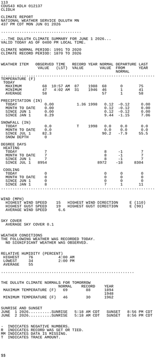
CDUS43 KDLH 012137
CLIDLH
CLIMATE REPORT
NATIONAL WEATHER SERVICE DULUTH MN
437 PM CDT MON JUN 01 2026
...................................
...THE DULUTH CLIMATE SUMMARY FOR JUNE 1 2026...
VALID TODAY AS OF 0400 PM LOCAL TIME.
CLIMATE NORMAL PERIOD: 1991 TO 2020
CLIMATE RECORD PERIOD: 1870 TO 2026
WEATHER ITEM OBSERVED TIME RECORD YEAR NORMAL DEPARTURE LAST
VALUE (LST) VALUE VALUE FROM YEAR
https://mesonet.agron.iastate.edu/p.php?pid=202606012137-KDLH-CDUS43-CLIDLH
#DLH #MNwx 110
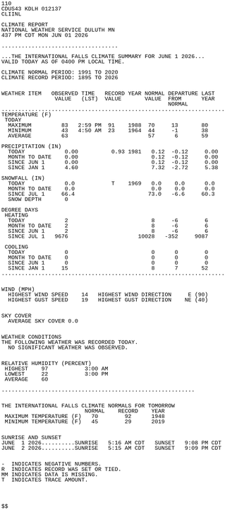
CDUS43 KDLH 012137
CLIINL
CLIMATE REPORT
NATIONAL WEATHER SERVICE DULUTH MN
437 PM CDT MON JUN 01 2026
...................................
...THE INTERNATIONAL FALLS CLIMATE SUMMARY FOR JUNE 1 2026...
VALID TODAY AS OF 0400 PM LOCAL TIME.
CLIMATE NORMAL PERIOD: 1991 TO 2020
CLIMATE RECORD PERIOD: 1895 TO 2026
WEATHER ITEM OBSERVED TIME RECORD YEAR NORMAL DEPARTURE LAST
VALUE (LST) VALUE VALUE FROM YEAR https://mesonet.agron.iastate.edu/p.php?pid=202606012137-KDLH-CDUS43-CLIINL
The Weather Prediction Center issues Day 5 Marginal Risk Excessive Rainfall Outlook at Jun 1, 20:00z for portions of MPX
https://www.wpc.ncep.noaa.gov/qpf/excessive_rainfall_outlook_ero.php