🗺️ A broken phone shouldn’t erase years of adventures.

Your tracks, routes, and saved places tell the story of where you’ve been 🌍

With Locus Map’s Backup Manager, you can automatically protect your outdoor data:
✔️ choose what to back up
✔️ choose where it’s stored
✔️ choose how often backups run

Explore freely. Your data stays safe 💪

#LocusMap #Hiking #Navigation #OutdoorTech #Backup

Trail idea → route in minutes. 🥾🗺️✨

With Locus Map, fast route planning means less time fiddling and more time hiking. Sketch your loop, check distance + elevation, adjust on the fly — then hit the trail with confidence. ⛰️

Where are you heading this weekend? 👇

#LocusMap #LocusMap4 #Hiking #RoutePlanning #OutdoorNavigation #ExploreMore #TrailLife

Planning season is here.
Our Locus Map Web Planner is now faster and smoother thanks to a new map engine (MapLibre). Less waiting, fewer hiccups — more time shaping the perfect route.

Try it and tell us: do you feel the difference? Drop a comment!

#LocusMap #LocusMap4 #WebPlanner #RoutePlanning #MapLibre #ExploreMore #OutdoorNavigation #Hiking #Cycling

@Milu
Ale tam se také platí, nebo se pletu ?
Zdarma je jen nějaký počet stažení map.
mapy.cz nemám rád z jiného důvodu, ale jsem v pohraničí a tak musím mít placenou verzi - 25Kč měsíčně nebo kolik to vyjde ... ?
Zkouším pravidelně #LocusMap , používal jsem je kdysi i platil, na turistiku nebylo nic lepšího, ale teď u nich něco naplánovat je takový opruz, opustil jsem je. Jednou za rok je vyzkouším, zaplatím měsíc, ale spíše se to zhoršuje, app je složitá, nepřehledná a plánování na WWW úplně na prd.

Placení se nebráním, skousnu i když něco nefunguje s nadějí opravy, ale tady to jde nějak jinam než by mi vyhovovalo.

🚴‍♂️ A new dimension for your rides.
Turn spring ideas into real routes — plan smarter, ride further, and stay confident even when the signal disappears 📴✨
With Locus Map Premium (Silver/Gold) you unlock the full toolkit:
🗺️ offline maps
📐 advanced planning
🎛️ more control over every trip
Ready to explore your next line on the map? Upgrade/renew Premium and go 🔥
#LocusMap #LocusMap4 #LocusMapPremium #ExploreMore #Cycling #BikeAdventure #OfflineMaps #RoutePlanning #OutdoorNavigation

🥾 Whether you're chasing new peaks, exploring local trails, or planning a weekend escape — Locus Map 4 is your map-first hiking companion.

🗺️ Detailed maps at hand
📴 Offline hiking navigation
📍 Reliable route planning
📊 Track recording for every hike
Pick your trail. Pack water. And let the map do the heavy lifting. 💪
What hike are you starting the season with? 🌄
#LocusMap #LocusMap4 #Hiking #OfflineMaps #RoutePlanning #ExploreMore #OutdoorAdventure

Met #Baliverne gevaren route bij gehouden in #locusmap
Difficult terrain, railroad crossings, barriers, gates, heavy traffic... everything you need to be aware of on your trip is now on the map of your route in Locus Map Web Planner. You can also see them in the itinerary and in a warning box, with distances and coloring according to severity (red is the strongest). #safetyfirst #outdoorlife #exploremore #LocusMap

Locus Map 4.33 just dropped — and it's a big one.
🚗 Android Auto support is here. Display any of your maps on the car screen, search by voice, navigate turn-by-turn. Your phone stays free for track recording and everything else.
Plus:
📷 Browse photos & videos with your recorded tracks
📊 Redesigned track charts
🔧 Simpler routing profile selection
⚙️ Full custom BRouter profile support
Spring's calling — time to explore.
🔗 https://www.locusmap.app/locus-map-4-33-introduces-support-for-android-auto-and-a-host-of-other-new-features/

#LocusMap #AndroidAuto #GPSNavigation #OutdoorApp

Tak jsem to s #LocusMap vzdal 🤷‍♂️
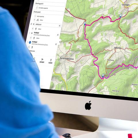
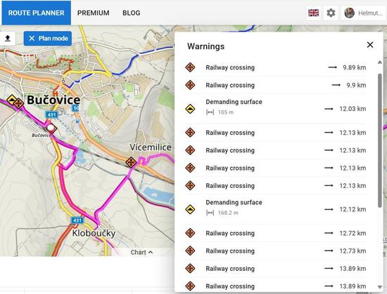
Plánování tras na kole zmáknuté nemají. Je to spíše tragédie.
Jelikož jsem pár km od hranic, musím si #mapy_cz platit - jedna mapa mi je k 💩
Vracím se na rok k zajetým kolejím (bohužel)...
- mapy_cz jako hlavní mapa a na hrubé plánování, hledání ubytování, hledání přístřešků atd. (placené). Bohužel pořád nelze použít na geocaching.
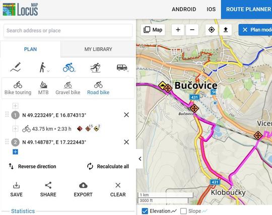
- gpxmapy.cz pro detailní doplánování (jejich editor umožňuje zrušit routování i na část cesty) - free
- #geocaching návrat k #cgeo (sponzoruji)
- naše "udělátko" které stáhne kešky ze zvoleného kraje do GPX (nebo zvoleného rádiusu) - omezeno na 1000 keší, nově umíme označit pro zvoleného uživatele jako "nalezené". C:GEO to umí také, ale náš script je asi 100x rychlejší a lze ho spustit i na PC.