Surprisingly, Missouri's Grundy County has a scanner feed...

PDS Flash Flood Emergency in Trenton, Missouri.
Flash Flood Warning
MOC079-170830-
/O.NEW.KEAX.FF.W.0016.260517T0235Z-260517T0830Z/
/00000.U.ER.000000T0000Z.000000T0000Z.000000T0000Z.OO/
BULLETIN - EAS ACTIVATION REQUESTED
Flash Flood Warning
National Weather Service Kansas City/Pleasant Hill MO
935 PM CDT Sat May 16 2026
...FLASH FLOOD EMERGENCY FOR SOUTHERN GRUNDY AND THE CITY OF TRENTON,
MO...
The National Weather Service in Pleasant Hill has issued a
* Flash Flood Warning for...
Central Grundy County in north central Missouri...
* Until 330 AM CDT.
* At 935 PM CDT, Emergency management reported thunderstorms
producing heavy rain across the warned area with numerous roads
flooded and some buckled. Between 5.5 and 7.5 inches of rain have
fallen. Another line of storms will bring additional extremely
heavy rainfall. The expected rainfall rate is 1.5 to 2.5 inches in
1 hour. Additional rainfall amounts of 2 to 4 inches are possible
in the warned area. Flash flooding is already occurring.
FLASH FLOOD EMERGENCY for Southern Grundy and the City of Trenton,
MO. This is a PARTICULARLY DANGEROUS SITUATION. SEEK HIGHER GROUND
NOW!
HAZARD...Life threatening flash flooding. Thunderstorms producing
flash flooding.
SOURCE...Emergency management reported.
IMPACT...This is a PARTICULARLY DANGEROUS SITUATION. SEEK HIGHER
GROUND NOW! Life threatening flash flooding of low water
crossings, small creeks and streams, urban areas,
highways, streets and underpasses.
PRECAUTIONARY/PREPAREDNESS ACTIONS...
Move to higher ground now! This is an extremely dangerous and
life-threatening situation. Do not attempt to travel unless you are
fleeing an area subject to flooding or under an evacuation order.
Be especially cautious at night when it is harder to recognize the
dangers of flooding.
&&
LAT...LON 4016 9376 4015 9339 3999 9339 4004 9376
FLASH FLOOD...OBSERVED
FLASH FLOOD DAMAGE THREAT...CATASTROPHIC
EXPECTED RAINFALL RATE...1.5-2.5 INCHES IN 1 HOUR
$$
CDB
PDS Flash Flood Emergency in Roanoke, Virginia.
* At 902 PM EDT, gauge reports indicated thunderstorms producing
heavy rain across the warned area. Between 3 and 5 inches of rain
have fallen. Flooding impacts will continue, but no additional
rainfall is expected. Flash flooding is already occurring.
This is a FLASH FLOOD EMERGENCY for The City of Roanoke, and the
city of Salem . This is a PARTICULARLY DANGEROUS SITUATION. SEEK
HIGHER GROUND NOW!
Matt Lanza: "Almost made it through the day without a flash flood emergency. Alas. This is for an area just west of Effingham, IL, east of St. Louis. About 5-7” estimated on radar and 1-2”+ in the last hour." #ILwx #FlashFloodEmergency
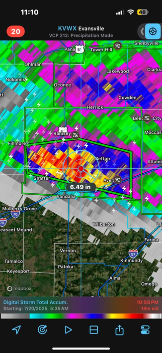
FLASH FLOOD EMERGENCY in Illinois
495
WGUS53 KLSX 210408
FFWLSX
ILC051-210715-
/O.NEW.KLSX.FF.W.0033.250721T0408Z-250721T0715Z/
/00000.0.ER.000000T0000Z.000000T0000Z.000000T0000Z.OO/
BULLETIN - EAS ACTIVATION REQUESTED
Flash Flood Warning
National Weather Service St Louis MO
1108 PM CDT Sun Jul 20 2025
...FLASH FLOOD EMERGENCY FOR CENTRAL FAYETTE COUNTY...
The National Weather Service in St Louis has issued a
* Flash Flood Warning for...
Northwestern Fayette County in south central Illinois...
* Until 215 AM CDT.
* At 1108 PM CDT, local law enforcement reported thunderstorms
producing heavy rain across the warned area. Between 5 and 6
inches of rain have fallen. The expected rainfall rate is 2 to 3
inches in 1 hour. Additional rainfall amounts of 2 to 3 inches are
possible in the warned area. Flash flooding is already occurring.
FLASH FLOOD EMERGENCY for central Fayette County. This is a
PARTICULARLY DANGEROUS SITUATION. SEEK HIGHER GROUND NOW!
HAZARD...Life threatening flash flooding. Thunderstorms
producing flash flooding.
SOURCE...Law enforcement reported.
IMPACT...This is a PARTICULARLY DANGEROUS SITUATION. SEEK
HIGHER GROUND NOW! Life threatening flash flooding of
low water crossings, small creeks and streams, urban
areas, highways, streets and underpasses.
https://mesonet.agron.iastate.edu/wx/afos/p.php?pil=FFWLSX&e=202507210408

Maybe this will make them think twice about cutting NWS but then again, maybe not.
Flash Floods in central Maryland and Washington D.C. prompt water rescues and a Flash Flood Emergency
More than 100 flood-related emergency calls were reported in Montgomery County, Maryland, on Saturday evening, July 19, 2025, after thunderstorms brought up to 127 mm (5 inches) of rain in less than two hours, prompting a Flash Flood Emergency from the National Weather Service. #weather #FlashFloodEmergency #MDwx #DCwx
https://watchers.news/2025/07/20/flash-floods-central-maryland-washington-dc-flash-flood-emergency/

LWX issues Flash Flood Emergency [flash flood: observed, flash flood damage threat: catastrophic] for Montgomery [MD] till Jul 19, 9:00 PM EDT * At 554 PM EDT, Emergency management reports significant flash flooding along the Sligo Creek Watershed. Between 3 and 5 inches of rain have fallen. The expected rainfall rate is 1 to 2 inches in 30 minutes. Additional rainfall amounts of 1 to 2 inches are possible in the warned area. Flash flooding is already occurring. #weather #FlashFloodEmergency #Montgomery #MDwx
https://mesonet.agron.iastate.edu/vtec/?year=2025&wfo=KLWX&phenomena=FF&significance=W&eventid=119&tab=info&radar=USCOMP&radar_product=N0Q&radar_time=202507192150

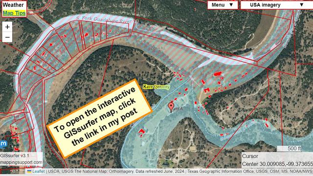
The state of Texas has a GIS layer that shows building footprints. That data is solid red on this map.
Along the river the area with red diagonals is the ‘regulated floodway’ as identified by FEMA. **Note all the buildings in the floodway**.
The map should also display red lines which show tax parcels. If the red parcel lines do not display when the map opens then try zooming the map out and then in.
The marker on the map is roughly centered on the large Camp Mystic property.
#texas #disaster #flooding #FlashFloodEmergency #TXwx
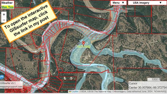
When this map opens it is centered on the large Camp Mystic property in Texas. The red lines identify parcels. The parcels are clickable.
Along the river the area with red diagonals is the ‘regulated floodway’ as identified by FEMA.
If you play with the map then you will see lots of buildings in the ‘regulated floodway’.
If the red parcel lines do not display when the map opens then try zooming the map out and then in.
#texas #disaster #flooding #FlashFloodEmergency #TXwx
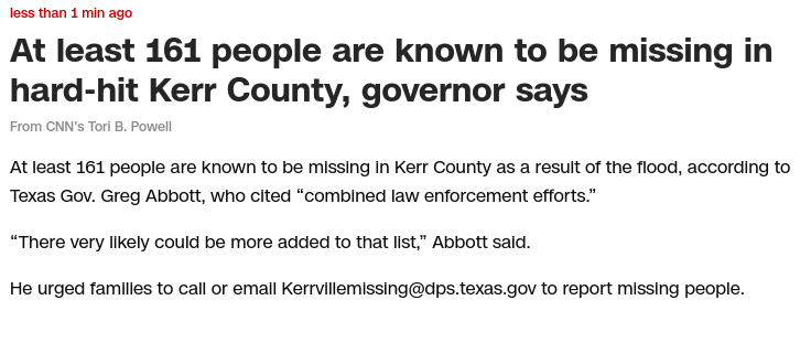
CNN "At least 161 people are known to be missing in Kerr County as a result of the flood, according to Texas Gov. Greg Abbott, who cited “combined law enforcement efforts.”"
#texas #flooddisaster #TXwx #Kerrville #flooding #FlashFloodEmergency