#EAX #MOwx 955
WWUS53 KEAX 101411
SVSEAX

Severe Weather Statement
National Weather Service Kansas City/Pleasant Hill MO
911 AM CDT Wed Jun 10 2026

MOC025-061-117-101420-
/O.CAN.KEAX.SV.W.0328.000000T0000Z-260610T1430Z/
Daviess MO-Caldwell MO-Livingston MO-
911 AM CDT Wed Jun 10 2026

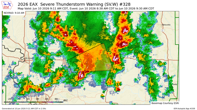
...THE SEVERE THUNDERSTORM WARNING FOR SOUTHEASTERN DAVIESS...
NORTHEASTERN CALDWELL AND LIVINGSTON COUNTIES IS CANCELLED...

The storm which prompted the warning has weakened below seve https://mesonet.agron.iastate.edu/vtec/f/2026-O-CAN-KEAX-SV-W-0328_2026-06-10T14:11Z

KEAX Severe Thunderstorm Warning #328

Caldwell, Daviess, Livingston

Iowa Environmental Mesonet

#EAX #MOwx 766
WWUS53 KEAX 101402
SVSEAX

Severe Weather Statement
National Weather Service Kansas City/Pleasant Hill MO
902 AM CDT Wed Jun 10 2026

MOC025-061-117-101430-
/O.CON.KEAX.SV.W.0328.000000T0000Z-260610T1430Z/
Daviess MO-Caldwell MO-Livingston MO-
902 AM CDT Wed Jun 10 2026

...A SEVERE THUNDERSTORM WARNING REMAINS IN EFFECT UNTIL 930 AM CDT
FOR SOUTHEASTERN DAVIESS...NORTHEASTERN CALDWELL AND LIVINGSTON
COUNTIES...

At 902 AM CDT, a severe thunderstorm was https://mesonet.agron.iastate.edu/vtec/f/2026-O-CON-KEAX-SV-W-0328_2026-06-10T14:02Z

KEAX Severe Thunderstorm Warning #328

Caldwell, Daviess, Livingston

Iowa Environmental Mesonet

#EAX #MOwx 924
WUUS53 KEAX 101338
SVREAX
MOC025-061-117-101430-
/O.NEW.KEAX.SV.W.0328.260610T1338Z-260610T1430Z/

BULLETIN - IMMEDIATE BROADCAST REQUESTED
Severe Thunderstorm Warning
National Weather Service Kansas City/Pleasant Hill MO
838 AM CDT Wed Jun 10 2026

The National Weather Service in Pleasant Hill has issued a

* Severe Thunderstorm Warning for...
Southeastern Daviess County in north central Missouri...
Central Caldwell County in north central Missouri. https://mesonet.agron.iastate.edu/vtec/f/2026-O-NEW-KEAX-SV-W-0328_2026-06-10T13:38Z

KEAX Severe Thunderstorm Warning #328

Caldwell, Daviess, Livingston

Iowa Environmental Mesonet

#EAX #MOwx 986
WWUS83 KEAX 101323
SPSEAX

Special Weather Statement
National Weather Service Kansas City/Pleasant Hill MO
823 AM CDT Wed Jun 10 2026

MOZ014-021>023-101400-
Clinton MO-Daviess MO-Livingston MO-Caldwell MO-
823 AM CDT Wed Jun 10 2026

...A STRONG THUNDERSTORM WILL IMPACT SOUTHEASTERN DAVIESS...
NORTHEASTERN CLINTON...CALDWELL AND SOUTHWESTERN LIVINGSTON COUNTIES
THROUGH 900 AM CDT...

At 823 AM CDT, Doppler radar was tracking a strong thunderstorm near
https://mesonet.agron.iastate.edu/p.php?pid=202606101323-KEAX-WWUS83-SPSEAX

IEM :: SPS from NWS EAX

SPS issued by NWS EAX at 10 Jun 2026 13:23 UTC

#EAX #MOwx 267
WUUS01 KWNS 101255
PTSDY1

DAY 1 CONVECTIVE OUTLOOK AREAL OUTLINE
NWS STORM PREDICTION CENTER NORMAN OK
0754 AM CDT WED JUN 10 2026

VALID TIME 101300Z - 111200Z

PROBABILISTIC OUTLOOK POINTS DAY 1

... TORNADO ...

0.02 48529098 47688931 46618777 45978720 44548562 43818518
42658530 41778569 40868625 39678784 39069267 37609630
37929696 38559675 39179630 40319568 41419520 42309428
43529385 44609418 45469559 46319631 49739704
0.05 https://www.spc.noaa.gov/products/outlook/archive/2026/day1otlk_20260610_1300.html

#EAX #MOwx 103
WWUS83 KEAX 101252
SPSEAX

Special Weather Statement
National Weather Service Kansas City/Pleasant Hill MO
752 AM CDT Wed Jun 10 2026

MOZ013-020-021-101330-
Buchanan MO-Clinton MO-De Kalb MO-
752 AM CDT Wed Jun 10 2026

...A STRONG THUNDERSTORM WILL IMPACT EAST CENTRAL BUCHANAN...NORTHERN
CLINTON AND SOUTHERN DEKALB COUNTIES THROUGH 830 AM CDT...

At 752 AM CDT, Doppler radar was tracking a strong thunderstorm near
Gower, moving northeast at 30 mph.

H https://mesonet.agron.iastate.edu/p.php?pid=202606101252-KEAX-WWUS83-SPSEAX

IEM :: SPS from NWS EAX

SPS issued by NWS EAX at 10 Jun 2026 12:52 UTC

#EAX #MOwx 289
WWUS83 KEAX 101248
SPSEAX

Special Weather Statement
National Weather Service Kansas City/Pleasant Hill MO
748 AM CDT Wed Jun 10 2026

MOZ005-014-015-101315-
Grundy MO-Daviess MO-Harrison MO-
748 AM CDT Wed Jun 10 2026

...A STRONG THUNDERSTORM WILL IMPACT NORTHEASTERN DAVIESS...
SOUTHWESTERN GRUNDY AND SOUTHEASTERN HARRISON COUNTIES THROUGH 815 AM
CDT...

At 748 AM CDT, Doppler radar was tracking a strong thunderstorm near
Gallatin, moving northeast at https://mesonet.agron.iastate.edu/p.php?pid=202606101248-KEAX-WWUS83-SPSEAX

IEM :: SPS from NWS EAX

SPS issued by NWS EAX at 10 Jun 2026 12:48 UTC

#EAX #MOwx 538
ACUS11 KWNS 101243
SWOMCD
SPC MCD 101243
ILZ000-IAZ000-MOZ000-KSZ000-101445-

Mesoscale Discussion 1063
NWS Storm Prediction Center Norman OK
0743 AM CDT Wed Jun 10 2026

Areas affected...Northern Missouri into southeast Iowa

Concerning...Severe potential...Watch unlikely

Valid 101243Z - 101445Z

Probability of Watch Issuance...20 percent

SUMMARY...Weak convection will move into an increasingly unstable
environment by late morning/early afternoon. T https://www.spc.noaa.gov/products/md/2026/md1063.html

#EAX #MOwx 460
FXUS63 KEAX 101142
AFDEAX

Area Forecast Discussion
National Weather Service Kansas City/Pleasant Hill MO
642 AM CDT Wed Jun 10 2026

.KEY MESSAGES...

* Enhanced Risk (level 3 of 5) for severe weather this
afternoon and evening. Large hail and damaging winds are the
primary concerns, but can't rule out the possibility of
tornadoes.

* Enhanced Risk for severe weather again Thursday afternoon and
early evening. Large hail, damaging winds, and https://mesonet.agron.iastate.edu/p.php?pid=202606101142-KEAX-FXUS63-AFDEAX

IEM :: AFD from NWS EAX

AFD issued by NWS EAX at 10 Jun 2026 11:42 UTC

National Weather Service - Pleasant Hill-Kansas City, MO #MOwx #EAX #NWS #WX