Getting underway with the "move my #CGHMN server to real hardware" project. The poll I posted a few days ago said y'all wanted me to run OpenBSD 3.0, but I found that it didn't work well with my hardware so I settled for Linux. Although I'm doing something interesting: I'm running #LinuxFromScratch! Specifically LFS 3.3. After solving the performance problems I was having with the VIA C3 CPU, the bottleneck at this point seems to be the CF card I'm using for storage.
I'm considering moving my main #CGHMN server from a QEMU VM to some real vintage hardware. I'm considering two OS options:
* OpenBSD 3.0: current VM OS, has some novelty value, and I own a physical copy
* Slackware 8.1: more practical benefits, easier to find software and docs for
What do you think, #RetroComputing Fedi? 
OpenBSD 3.0 🐡
Slackware 8.1 🐧
Poll ended at .
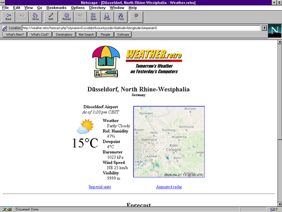
Tomorrow's Weather on Yesterday's Computers
For most of the last month, I've been working on a retro-friendly weather forecast website for #CGHMN. I decided to develop the site itself using a modern LAMP stack due to the need to call modern APIs for weather data, although the output is pure HTML 3.2 without a single line of JavaScript.Before I wrote any code, I commissioned my friend @[email protected] to make a logo for the site. Someone on Fedi suggested a retro computer with an umbrella, so we went with that. I used the Google color emoji set for placeholder art to represent various weather conditions with the expectation of replacing them with original work later. (as I write this, @[email protected] has offered to make some)
I decided to use the Open-Meteo API for forecast data. They don't provide local observation data though; their current conditions are model estimates. I wanted to provide accurate info, so I figured my best bet would be to pull and parse METAR reports from the US's NOAA. I set up a MariaDB database to hold a list of all the available weather stations with their coordinates (from OurAirports ) and most recent report, and made a cronjob to update them all every hour. I used Safran Cassiopée's php-metar-decoder to handle decoding, and wrote a little function to convert the current conditions reported to a generally-equivalent WMO 4677 code.
Since Open-Meteo needs a set of geographic coordinates to get local forecasts, I needed a geocoding solution. They offer a geocoding API based on GeoNames data, but I wasn't entirely happy with it. I ended up loading the GeoNames datasets directly into my MariaDB server and setting up the code to query that. This was the first time I'd dealt with a ~5 million-line database, so I had to learn a bit about indexing and optimization to get it to perform decently.
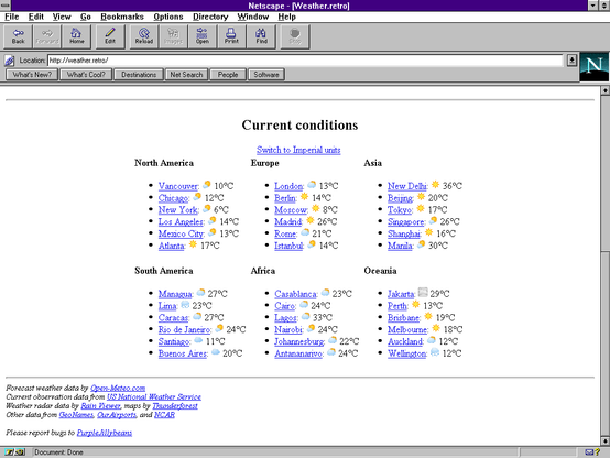
Next, I wanted to have a list of current weather conditions for major world cities on the landing page. I decided to include six cities from each continent, though it was a bit tricky to determine which ones to pick. I asked Fedi for some recommendations. The end goal was to give an at-a-glance summary of weather around the globe. Of course, in addition to picking which cities to use, in most cases I also had to figure out which airport to take a representative report from. I generally went with whatever was closest to the city center, rather than the largest or busiest.
With current and future weather settled, the next thing I wanted to add was radar. The need to work worldwide complicated things but some of the folks in the CGHMN IRC chat pointed me to Rain Viewer, which offers a free API. It's a bit slow but it did what I needed. They only provide the radar data itself though, so I was still on my own to come up with a base map. For that I chose Thunderforest, who provide an API based on OpenStreetMap data. Thankfully both APIs used the same arguments for location and scale factor so they meshed together well.
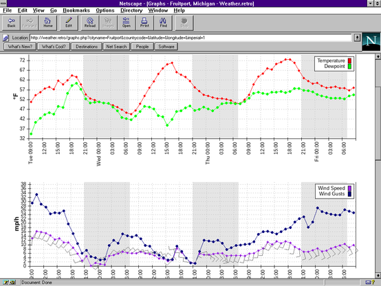
I experimented with a few different layouts for the forecast info, first trying a table with days as rows and hours as columns, then a format suggested by Loganius on CGHMN with days as columns, before ultimately settling on a simple row of daily summaries. To provide detail, I set up a separate page with a set of graphs showing hourly forecast data for a three-day period. I used PHPlot to draw the graphs server-side. The library hasn't been updated since 2015 but it still works with PHP 8.4, surprisingly enough. I based the layout of the graphs on the ones on the US National Weather Service's site. Most of the plotting was handled automatically by PHPlot but I had to write a few custom callbacks for the wind barbs and nighttime indicators.
At this point the site is essentially done, though I've been thinking about other meteorological information I could provide. It all depends on what I'm able to find free or reasonably-priced APIs for. I'm a bit inspired by the NCAR Research Applications Laboratory site, though that's strongly US-centric and I'm aiming for world coverage.
#blog
🟢 PurpleJillybeans just went live on Owncast!
Quake 3 Arena (1999) | Playing on CGHMN!
#owncast #streaming #goinglive #livenow #videogames #fedilive #RetroGaming #CGHMN #LinuxGaming
Upcoming #RetroGaming events!
* TONIGHT, 0100 UTC/9 PM EDT: #Quake3Arena on #CGHMN! We'll be playing version 1.16n and there's a possibility some folks on #Dreamcast will join in!
* SATURDAY 11 April, 1900 UTC/7 PM CEST: #UnrealTournament #UT99 for #FediverseFragNight!
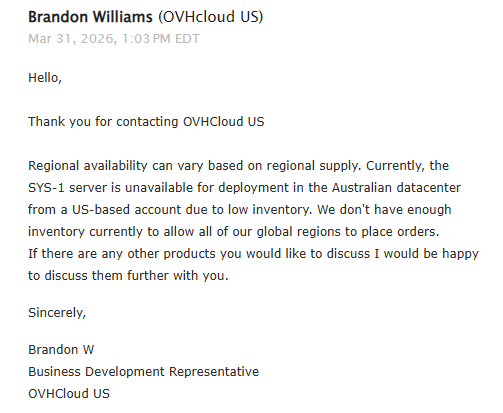
One of the network goals for #CGHMN has been better global availability. We put a server in the US, Europe and Australia. You connect to your closest node and benefit from less latency to local peers and less transit latency from a datacenter backbone versus your ISP's cheap as fuck peering
Except for some reason OVH *will not rent* servers out of their Sydney datacenter to Americans. Only Australians
Why the fuck they'd rather have servers sit powered off not making money is beyond me, but
I have it up on my #CGHMN site if anyone wants to play with it there:
http://www.n8fq.retro/java_metars
It's still getting its data from NCAR's server for now (updated half-hourly with a cronjob) but I'll eventually work on REing it and ingesting from a more permanent source.
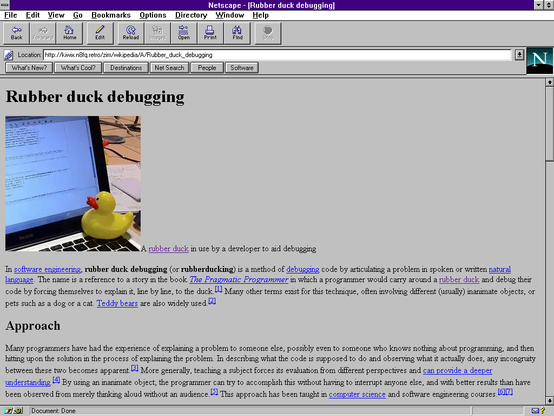
My latest frivolous #RetroComputing project: a #Kiwix ZIM reader for vintage web browsers.
If you're curious, it's on #CGHMN at http://kiwix.n8fq.retro
Edit: Source at https://codeberg.org/PurpleJillybeans/zimget