11 Followers
71 Following
54 Posts
@richlv he's the one falling from an unfinished road in a red car?... rolling rolling rolling, ohey...
@osm_tech I wonder if QGIS is not requesting the same raster tiles again and again as it is doing for vector tiles where it fetches the same tile 4-8 times for one render (not for zoom in-out)...
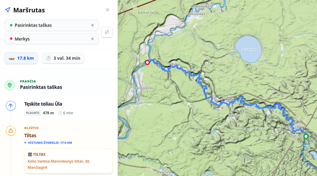
🚣 Kayaking season is here again!
We've moved our river-routing to the new portal. And you can share your calculated routes πŸ—ΊοΈ with your friends with an link πŸ”— like this: https://openmap.lt/river/?z=12.77&lat=54.14573&lng=24.39984&bearing=0&pitch=0&startLat=54.12731&startLng=24.46499&startName=Pasirinktas+ta%C5%A1kas&endLat=54.16306&endLng=24.33369&endName=Merkys&profile=kayak #OpenStreetMap

Hello hello! Another three years have passed, and the quiet local @openstreetmap conference in Eastern Europe is coming to Riga once more!

Just for one day β€” 4 June 2026 β€” but we will sure plan something on the evening before and morning after. Subscribe to this account for news, register for the conference, buy plane tickets (sorry, no Rail Baltica yet), and think on your talk topic!

Everything's here: https://2026.sotm-baltics.org/

Interesting post about #openstreetmap waterway tagging. It mentions some new and rare types. I definately see flowline being used.
https://imagico.de/blog/en/the-ways-of-the-water-in-openstreetmap/
The ways of the water in OpenStreetMap | Imagico.de

@richlv remove roads and remaining landuse looks bad, it means details are excesive. Classic case of tracing colour rather than meaning. Makes data and digital maps unnecessary heavy and clutered.
In years of openmap.lt existence we've created a number of different small web-apps for different purposes: general map, tourism, kayaking, craft-beer etc. But in next generation map we decided to put all of it into one web-app. Therefore we need "profiles", which would mean not only different map style (and thus different displayed and enhanced/hidden features), but also different legend/filter and different search capabilities. This lego brick we hope will give us lots of other possibilities.
We will see, code will be on github.
Global projects have other problems... but that is another complex story.
Maybe some neighbours could benefit... ;-)

We have a lot of products and services in Lithuanian πŸ—ΊοΈ openmap.lt family, but all of them were kind of forgotten.

So we've started a new project - ⏭️ NextGet aiming to refresh all of it:
* move all of the software to Lithuanian OpenMap association servers,
* move all code to github,
* refresh or rewrite software using todays technologies.

Work has already started on one of the oldest and most popular - places portal: https://nextgen.openmap.lt/#p/13.23/54.63631/24.94370/0/0

#osm #openstreetmap #lithuania

It's been a long journey (over year since I began), but there's finally now a first public release of the oblique hachures method. With many thanks to @SouthArrowMaps, who significantly refined the methodology from what I began with.

Writeup: https://docs.google.com/document/d/1GFSgxLI5F2UOevCXBG22GBKVbpuKddTl7MoBTrPHB3s/edit?tab=t.0

Script: https://github.com/pinakographos/non-planimetric-hachures

#cartography