 Luís de Sousa
Here is a bit of a preview on where things are with the #GeoPlegma project. More soon to come.
https://www.linkedin.com/posts/joaocsmanuel_dggs-geoplegma-deckgl-ugcPost-7463623488235372545-NAIp
#dggs #geoplegma #deckgl #geoinsight | João Manuel
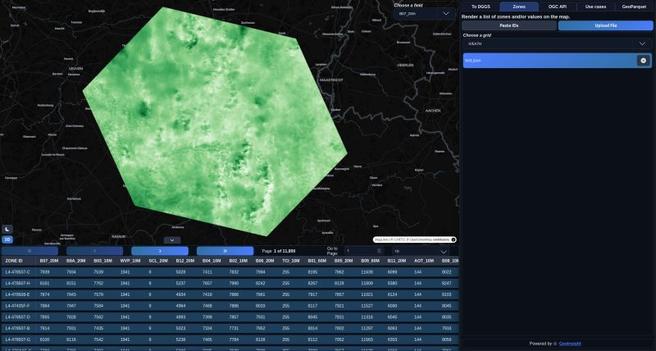
At GeoInsight, we’ve been building dggs.io for a while now, continuously improving it as this demo product evolves. For those unfamiliar: dggs.io is a website for exploring and visualizing DGGS (Discrete Global Grid System) data, making spatial indexing systems easier to inspect, experiment with, and work with visually. A lot of DGGS tooling assumes your data is already tied to a specific rendering stack or grid implementation. That makes data exploration harder than it should be. I also wanted to visually test the work we have been doing at GeoPlegma (https://lnkd.in/eTdKBAAs). So I added a new capability (in dggs.io/zones) You can now visualize data directly from DGGS zone IDs by: • Uploading JSON files (specific format, check the paste section) • Loading Parquet datasets • Reading Zarr data (although this only requires a parent ID, and the depth of the refinement level) • Pasting zone IDs directly (specific format) You only need your IDs and it's associated data. I use deck.gl to visualize on the map. This works across multiple DGGS grids, deck.gl native ones (H3, A5, QUADKEY, S2, GEOHASH) and including systems outside deck.gl’s native support, with interoperability across ecosystems like and Geoplegma-compatible grids (IVEA7H, ISEA3H, etc, which are coming from DGGAL). The goal is simple: Reduce the friction between having DGGS-indexed data and actually exploring it visually. No custom preprocessing pipeline. No assumptions about a single grid ecosystem. No injected geometries, you just load zone IDs with your integrated data, and inspect the data. This is the kind of the product problem I enjoy solving. The screenshots are from the Sentinel-2 bands integrated into a DGGS grid from a json file, and the other one is a DEM from Canada, from a parquet one. These files were generated by our API. If you notice something is off or a bug with the website, please let me know privately, and if you also want I can provide examples. Also, if you work with DGGS or spatial indexing systems, I’d love to hear what tooling gaps still slow you down. Special thanks to Michael Jendryke, Dr. #dggs #geoplegma #deckgl #geoinsight