OpenStreetMap friends. Not being very technical, I’m struggling to use Overpass or turbo). I would like to download a global dataset of landuse=allotments (maybe in chunks) for a project idea. Can anyone help?
@stevenfeldman Postpass!
It's a global SQL database accessible over the web.
It's a global SQL database accessible over the web.
@amapanda could you help me out with the query to download landuse=allotments as geojson?
@stevenfeldman sure!
You want all the allotment areas, but as a point, and just their name?
Start here <https://overpass-turbo.eu/s/2qii> Is that the data you want? It's just a bbox query for now
You want all the allotment areas, but as a point, and just their name?
Start here <https://overpass-turbo.eu/s/2qii> Is that the data you want? It's just a bbox query for now
@stevenfeldman
actual “just give me everything in the world” isn't much slower.
here's overpass turbo trying to load whole word <https://overpass-turbo.eu/s/2qij>
MapLibre fares better, here's all the queries <https://overpass-ultra.us/#m=1.37/20.6278/0.0000&q=LQhQBcE8AcFMC4AE0D2Bnc0CGa2hMKKAMoCiAMqQMIAqi4WA5msAHysDkAdlgLawdEORD34AaRMRoB9AIIAnWFgAUjWCl7x4alI3lZoAC0gBKIWiGKs03gCYJ6XtKhwHaJwEsAJhKnSACigeXOAA8lzEAK7yAGZYAMawquq8ZsI6vKCIiABiAEqhALLI6Jg4aNKoADaQjChcWYgA6gASpHmk2QzMiAACrIgcAN4ARFVYXF6RaLAjSCNYVVUo4PwhaCMAvhxaAFLEoQByAEJAA>
@stevenfeldman Heck, here's the geojson. Just open this URL and save the resulting geojson <https://postpass.geofabrik.de/api/interpreter?data=%0ASELECT%20tags-%3E%3E%27name%27%20as%20name%2C%20ST_Area%28geom%3A%3Ageography%29%20as%20area_m2%2C%20osm_type%2C%20osm_id%2C%20ST_PointOnSurface%28geom%29%20as%20geom%0A%20%20FROM%20postpass_polygon%0A%20%20WHERE%20%20tags%20%40%3E%20%27%7B%22landuse%22%3A%20%22allotments%22%7D%27%3A%3AJSONB>
@stevenfeldman god i hope all the dudes don't just click it and overload our servers. Let's hope the bots don't start scraping.
YOLO
YOLO
@amapanda That's amazing, thanks so so much

But I couldn’t have worked out how to use postpass without you so big thanks to you and to postpass and to @geofabrik

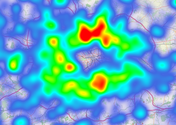
@stevenfeldman Did you know that maplibre can do heatmaps directly in your browser.
Here's a map showing density around London. Looks like there aren't many in the middle of London. 🤣🤣
https://overpass-ultra.us/#m=9.00/51.4013/0.0189&q=LQhQBcE8AcFMC4AE0D2Bnc0CGa2g5ADYKiKKFaSwBOa8pZiwiUcSAFrFuALZbQNGiTtz7Rg1LABMAlgFc6iAKwAGQYxG9+wAO6wZAc3bgkAbQBEB2OHMAaROazUuAfR4AmcwF11ZTWOAZADtwWCC0GSgkAEZYYCVQUBBgRIBlAFEAGXSAYQAVFiwDNGAAPlKAciCsHlgKxBxEatr7VLyXAEFnLAAKKxQeeHh+g0lodkgASga0Bu63d3t0HhdWWCW0FZkpVvaABRRg8AB5INS5agAzLABjWD7YAenG-p4GADEAJWOAWWR0TA4NAuVCESAGFBBBgAdQAEulPukyOAirMAAKlRAVADe5goQSkClg5iQjkIhBQvDC4DQ5gAvhUhgApVLHAByACFEB02QARRCvRAAMiFiDaLh+WAA1rB0kEAG6wClwHrY7F6NBBOl0+wAFgAzO4AGyTIA
@stevenfeldman The MapLibre heatmap documentation is a bit hard to understand and work with, but eh it's cool to have a link
Thanks
I am going in a different direction with this. I’ll share in a couple of days