OpenStreetMap friends. Not being very technical, I’m struggling to use Overpass or turbo). I would like to download a global dataset of landuse=allotments (maybe in chunks) for a project idea. Can anyone help?
@stevenfeldman Mmh, not sure if overpass is the best tool as there seem to be >400k objects, https://taginfo.openstreetmap.org/tags/landuse=allotments
What about osmium?
```
osmium tags-filter switzerland-latest.osm.pbf \
w/r landuse=allotments \
-o allotments.osm.pbf
osmium export allotments.osm.pbf -o allotments.geojson
```
@stevenfeldman I tried it for Switzerland. Obviously, the downside is that you need to download the whole planet file.
What I need is a point for each allotment with the area and maybe the name
@stevenfeldman Continuing on the command-line interface path, this could be accomplished using ogr2ogr and an SQL expression. Area calculation would need a proper projection.
I think I’ll have to download in chunks and then process in QGIS
@stevenfeldman you're using tools that would take you more time. If you can live with at, ok, but `ogr2ogr` is a much faster solution (granted, once you learned how to use it).
Presumably I still need to download the planer file?
@stevenfeldman Postpass!
It's a global SQL database accessible over the web.
It's a global SQL database accessible over the web.
@amapanda could you help me out with the query to download landuse=allotments as geojson?
@stevenfeldman sure!
You want all the allotment areas, but as a point, and just their name?
Start here <https://overpass-turbo.eu/s/2qii> Is that the data you want? It's just a bbox query for now
You want all the allotment areas, but as a point, and just their name?
Start here <https://overpass-turbo.eu/s/2qii> Is that the data you want? It's just a bbox query for now
@stevenfeldman
actual “just give me everything in the world” isn't much slower.
here's overpass turbo trying to load whole word <https://overpass-turbo.eu/s/2qij>
MapLibre fares better, here's all the queries <https://overpass-ultra.us/#m=1.37/20.6278/0.0000&q=LQhQBcE8AcFMC4AE0D2Bnc0CGa2hMKKAMoCiAMqQMIAqi4WA5msAHysDkAdlgLawdEORD34AaRMRoB9AIIAnWFgAUjWCl7x4alI3lZoAC0gBKIWiGKs03gCYJ6XtKhwHaJwEsAJhKnSACigeXOAA8lzEAK7yAGZYAMawquq8ZsI6vKCIiABiAEqhALLI6Jg4aNKoADaQjChcWYgA6gASpHmk2QzMiAACrIgcAN4ARFVYXF6RaLAjSCNYVVUo4PwhaCMAvhxaAFLEoQByAEJAA>
@stevenfeldman Heck, here's the geojson. Just open this URL and save the resulting geojson <https://postpass.geofabrik.de/api/interpreter?data=%0ASELECT%20tags-%3E%3E%27name%27%20as%20name%2C%20ST_Area%28geom%3A%3Ageography%29%20as%20area_m2%2C%20osm_type%2C%20osm_id%2C%20ST_PointOnSurface%28geom%29%20as%20geom%0A%20%20FROM%20postpass_polygon%0A%20%20WHERE%20%20tags%20%40%3E%20%27%7B%22landuse%22%3A%20%22allotments%22%7D%27%3A%3AJSONB>
@stevenfeldman god i hope all the dudes don't just click it and overload our servers. Let's hope the bots don't start scraping.
YOLO
YOLO
@amapanda That's amazing, thanks so so much

But I couldn’t have worked out how to use postpass without you so big thanks to you and to postpass and to @geofabrik

@stevenfeldman Did you know that maplibre can do heatmaps directly in your browser.
Here's a map showing density around London. Looks like there aren't many in the middle of London. 🤣🤣
https://overpass-ultra.us/#m=9.00/51.4013/0.0189&q=LQhQBcE8AcFMC4AE0D2Bnc0CGa2g5ADYKiKKFaSwBOa8pZiwiUcSAFrFuALZbQNGiTtz7Rg1LABMAlgFc6iAKwAGQYxG9+wAO6wZAc3bgkAbQBEB2OHMAaROazUuAfR4AmcwF11ZTWOAZADtwWCC0GSgkAEZYYCVQUBBgRIBlAFEAGXSAYQAVFiwDNGAAPlKAciCsHlgKxBxEatr7VLyXAEFnLAAKKxQeeHh+g0lodkgASga0Bu63d3t0HhdWWCW0FZkpVvaABRRg8AB5INS5agAzLABjWD7YAenG-p4GADEAJWOAWWR0TA4NAuVCESAGFBBBgAdQAEulPukyOAirMAAKlRAVADe5goQSkClg5iQjkIhBQvDC4DQ5gAvhUhgApVLHAByACFEB02QARRCvRAAMiFiDaLh+WAA1rB0kEAG6wClwHrY7F6NBBOl0+wAFgAzO4AGyTIA
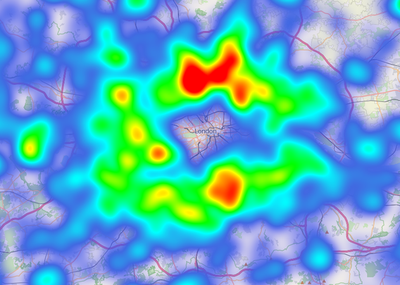
@stevenfeldman The MapLibre heatmap documentation is a bit hard to understand and work with, but eh it's cool to have a link
Thanks
I am going in a different direction with this. I’ll share in a couple of days
@stevenfeldman you could download the planet file. Then do osmium to filter out for only that tag.
Then with this smaller pbf file, convert to geojson (again with osmium).
Then with this smaller pbf file, convert to geojson (again with osmium).
@stevenfeldman For this kind of task, I second downloading the OSM planet file and applying Osmium.
I usually then use the same osmium to get a GeoJSON-lines file and open it in QGIS or process it with scripts.
Thanks I’ll give that a try