🔥 Mapping the Urban Thermal Environment: Summer 2025 Land Surface Temperature (LST) in Calgary
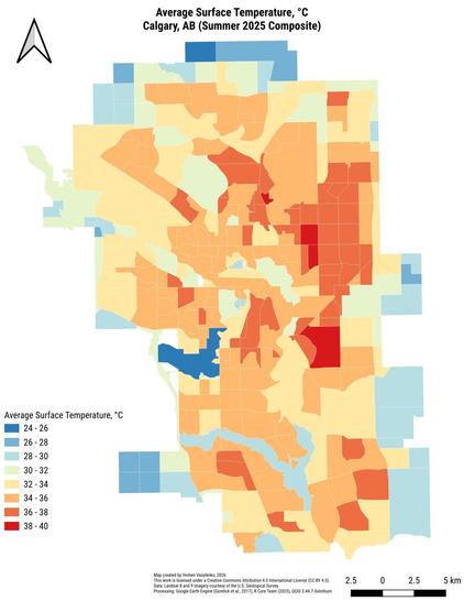
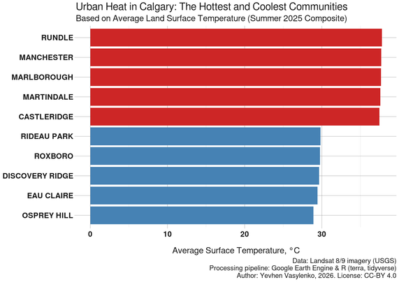
I am sharing the latest results of my spatial data analysis, focusing on the intra-urban thermal zones across Calgary, AB. The attached choropleth map and bar chart detail the average Land Surface Temperature. While the map shows whole city area, the bar chart made specifically for built-up residential communities. To ensure accurate and fair comparison, undeveloped greenfield areas and strictly industrial zones were filtered out.
❗ Based on the Summer 2025 satellite composite data:
🔴 The highest average LST values among residential areas were recorded in Rundle, Manchester, Marlborough, Martindale, and Castleridge.
🔵 The lowest average LST values were observed in Rideau Park, Roxboro, Discovery Ridge, Eau Claire, and Osprey Hill.
Find more interesting posts with hashtag #GreennessOfCalgary
#RStats #GISChat #QGIS #SpatialAnalysis #RemoteSensing #EarthObservation #UrbanEcology #OpenScience #YYC #Alberta #Canada