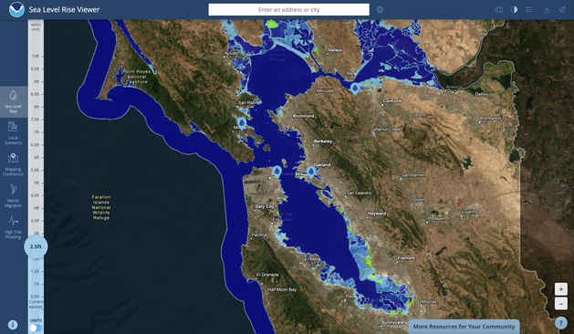
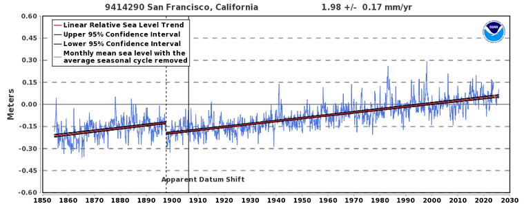
Highest astronomical high tides of year (aka the "King Tides") will occur this weekend in NorCal. But this year, they will coincide w/additional storm surge from nearby low pressure--causing potential for SF Bay Area coastal flooding beyond what we've seen in recent years. #CAwx
A moderately strong winter storm this wknd will bring low pressure and onshore/southerly winds to the SF Bay region. When combined w/ very high astronomical (King) tides, plus aggregate effect of long-term sea level rise, a 2.5+ feet elevation of SF Bay water levels is expected.
As NWS Monterey has emphasized, predicted water levels in SF will be the highest ever observed except for the notable coastal flood events in 1982/3 and 1998. As a result, considerable inundation of low-lying roads, infrastructure, and communities along SF Bay is likely. #CAwx
This wknd's storm is not, by any metric, extreme! (It won't even be as strong as last week's.) And astronomical (sun & moon gravity-related) King Tide is typical, as well. But coincidental timing of KT + moderate storm, added atop SLR, will generate a notable coastal flood event.
If you want to visualize what coastal areas (or coastally-connected areas, like the interior of SF Bay and the Bay Delta) may be inundated by various water heights (including this weekend's KT + storm + SLR event), you can use this NOAA visualization tool:
https://coast.noaa.gov/slr/#/layer/slr/2.5/-13621182.096332407/4552693.007645565/10.000/satellite/none/0.8/2050/interHigh/noAccretion/NOS_Minor