Time for a new topic. We will look at Viking 2 later.
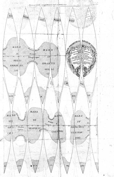
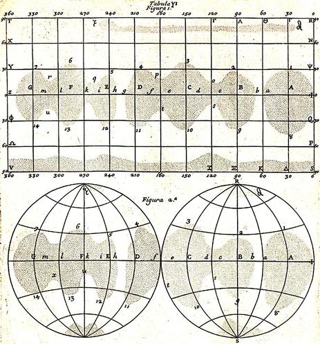
Pop quiz - which was the first solar system object after Earth and the Moon to be mapped? You at the back? - sorry, it's not Mars. No, the first after Earth and the Moon was Venus, by Francesco Bianchini, working in Rome. He made a globe of Venus in 1727 and published maps in a book in 1728. Of course the features are illusions, probably contrast effects in the eye.
#maps #venus #bianchini
Here are versions of that map in more easy-to-understand forms, cylindrical and azimuthal. Features are optical illusions, but I don't care - it's still a map. But why am I showing it here? Because, after my original atlas of lunar exploration I started work on an atlas of Venus and Mars exploration. It became apparent that Mars needed its own volume (and now there are three), so Venus went into its own book which is now abandoned.
#maps #venus #bianchini
Why abandon Venus? There's only so much one can do in a lifetime and I am pretty much devoting the rest of my life to the Moon.
#maps #venus

Bianchini was not the only person to map Venus before the space age. This paper by Percival Lowell:

https://adsabs.harvard.edu/pdf/1897MNRAS..57S.148L

presents observations, a map and a list of feature names for things that are obviously illusions. We see only clouds, contrasty in the ultraviolet but almost featureless in visible wavelengths. It might be - just barely - possible to argue that these lines originate in actual cloud features. There is another explanation too...
#maps #venus #lowell

In this article (presented page by page, but click 'print this article' to get a PDF of the whole thing):

https://articles.adsabs.harvard.edu//full/2003JHA....34...53S/0000057.000.html

Sheehan and Dobbins suggest the spoke pattern is a reflection of blood vessels in Lowell's eye. I am not totally convinced, feeling there ought to be more cases of it if true. But it is interesting.

Anyway, let's move on to more recent and reliable astronomy.
#maps #venus

2003JHA....34...53S Page 57

How about this for a weird map? But it is important. It comes from:

Boyer, C. and Camichel, H., 1961. Observations photographiques de la planète Vénus. Annales d'Astrophysique, Vol. 24, p. 531, 24, p.531.

https://articles.adsabs.harvard.edu//full/1961AnAp...24..531B/0000534.000.html

The authors took UV images of Venus in September 1953 and saw faint markings which they plotted in this map. Each day looked different, but the pattern repeats after 4 days. A 4 day segment is a global map of the clouds of Venus.
#maps #venus

At this time the rotation period of Venus was unknown. Lowell and many others thought the rotation was synchronous, like our Moon, with Venus always keeping the same face to the Sun. Various different rotation periods were suggested. Keep in mind that the surface was never seen and ideas varied from global desert to global ocean. Earth-based radar observed the surface from 1963 on, and revealed the 243 Earth day retrograde rotation. Soon after that we had the first radar maps.
#maps #venus

Let's take a peek at early Venus missions. In February 1961 two Soviet missions were launched - Sputnik 7 failed (the Sputnik designation concealed its planetary purpose) and Venera 1 made it to Venus, passing it at a distance of 100,000 km (the first ever planetary flyby). Sadly it had failed 10 days into the flight and provided no Venus data. It would have entered the atmosphere if luck prevailed but it didn't.

From July to September 1962 five missions launched to Venus...
#venus

... Three Soviet missions (Sputniks 19, 20 and 21) all failed and never left Earth, hence no 'Venera' designation. NASA launched Mariner 1 but it never got to orbit. Mariner 2 had better luck and became the first mission to return data from another planet - a very hot surface, a thick atmosphere of carbon dioxide, no magnetic field. Now we are getting somewhere! It was time plan some serious exploration.
#venus

In 2025 it's hard to understand how little Venus was known in the early 1960s. Those earliest Soviet probes were designed to float if they landed in an ocean. In 1963 this report:

Avco Corporation, 1963. Voyager design studies. Volume 1: Summary. Technical Report RAD-TR-63-34, 15 October 1963. Avco Research and Advanced Development Division, Wilmington, Massachusetts.

proposed a series of missions to both Venus and Mars...
#venus

... The project was called Voyager. When it was compiled the rotation period was unknown. This map shows a set of 3 Venus missions in successive launch opportunities. In 1970 probes would enter the atmosphere in mid-latitude sites straddling the terminator. In 1972 probes would study the sub- and anti-solar points. In 1973 and 1975 landers would go to those locations. Orbiters would map the planet as well. The map is blank because - they all were in 1963.
#maps #venus
I think the expressions 'hot pole' and 'cold pole' in the previous post imply that they still thought the rotation was synchronous. The true rotation state was only determined about the time this report was published. I should have added, Avco was under contract to NASA’s Office of Space Sciences for this study.

The first radar reflection from Venus was seen in 1961, and in 1962 the rotation was becoming clearer - retrograde and about 250 days. Irregularities in the radar spectra hinted at surface features. By 1964 they could be located roughly:

Goldstein, R. M., 1965. Preliminary Venus radar results. Journ. Res. Nat. Bur. Stds, Section D: Radio Science, v. 69D, pp. 1623-1625. https://nvlpubs.nist.gov/nistpubs/jres/69D/jresv69Dn12p1623_A1b.pdf

Finally a map with surface features...
#maps #venus

The surface of Venus gradually came into view more clearly. Here are two maps from 1965 (the linked paper) and 1969 (this paper:

Rogers, A.E.E. and Ingalls, R.P., 1969. Venus: Mapping the surface reflectivity by radar interferometry. Science, 165(3895), pp.797-799. )

Both are converted to my usual azimuthal projection. There were many steps between these and after, and a detailed history has never been put together. I used to dream of it.
#maps #venus

Goldstein only saw two features, Alpha and Beta (names we still use today). The other map by Rogers and Ingalls in 1969 shows many more features, unlabelled. The features in both maps are bright radar-reflective regions, meaning they are rough. Smooth areas appear dark, as do the unmapped areas around the periphery.

I think it's time for me to unveil my Venus map ... tomorrow...
#maps #venus

I needed a Venus map for my Atlas of Venus Exploration. Magellan was the only source of useful data. I combined two datasets: elevation from the radar altimeter and imaging from the SAR mapper. SAR shows craters and hills up close, but at global scale it mainly shows bright and dark (rough and smooth) areas. The elevation map is far inferior to our Moon and Mars datasets, and took a lot of cleaning up. Here is one side of the planet.
#maps #venus
There are more steps in the unveiling of Venus to come, so in a way this is out of sequence, but I needed to show it because it forms the background of other maps very soon.
The SAR image is shown very subdued here, draped over the shaded relief rendition of topography but just adding a few highlights like Beta Regio and Maxwell Montes. Tomorrow - the opposite hemisphere.
#maps #venus
Here is the other hemisphere of Venus. Most of the planet consists of plains, some smooth and some with ridges or various small volcanic features. Tessera areas are fractured hilly areas, apparently older than most plains. A few areas called Terra (Ishtar, Aphrodite and Leda) are high uplands - a bit like continents on Earth rising above the ocean floor. Lots of volcanoes but no obvious sign of plate tectonics. This was not my first Venus map...
#maps #venus

Some time in the 1980s, probably about 1984, before Magellan but with Pioneer Venus data and Earth-based radar, I made a hand-drawn pen and ink map of Venus on basically the same map projection. It was published in Sky and Telescope but I can't find the details - I have to dig through some dusty boxes. I will try to post it later in this thread. If you can find it, let me know!

Tomorrow, back to Venus missions.
#maps #venus

1964 was disastrous for Soviet Venus missions with four launches, only one of which left Earth orbit. That was Zond 1, but it failed on its way to Venus. 1965 was better. Venera 2 failed just before reaching Venus and flew silently past the planet. Venera 3, launched on 16 November 1965, entered the planet's atmosphere on 1 March 1966, the first ever physical contact with another planet. It failed just before it arrived, so no data. Where did it fall?
#venus
You are trying to hit a planet for the first time. Where do you aim? For the middle of the disk as you approach it? Aim for the edge and you may miss altogether. That doesn't work for Mars where an oblique entry at the edge of the disk is needed to get a long path through the thin atmosphere for braking. So, where was the middle of the disk during approach? This map reveals all. It's just the previous map in a different orientation.
#maps #venus
My last post showed where Venera 3 entered the atmosphere of Venus, with the surface mapped as we know it now. At the time this was utterly unknown. This region was not even in the area covered by those radar images. But let's look closer anyway. This map shows the middle part of that ellipse, mostly occupied by Manatum Tessera, a broad hilly area cut by many fractures. The 'undae' feature at top left is sand dunes, the corona features are volcanic complexes.
#maps #venus
Perhaps the most unusual feature in this map is Adivar, a small impact crater at top right, Adivar is the bight spot, and around it we see a less bright patch and then a dark horseshoe or inverted 'C' shape opening to the west. This is ejecta thrown out of the crater but blown westward by the prevailing wind. There are quite a few of these on Venus, just around younger craters. All these features are named after women.
#maps #venus
There were two other attempts at Venus in 1965 which did not leave Earth. The next opportunity was 1967. Venera 4 was launched on 12 June 1967 and entered the planet's atmosphere on 18 October, still functioning. It would float if it landed in water, which was still thought a possibility because Soviet scientists thought the very high temperatures reported by Mariner 2 were in the ionosphere, not the surface. It failed at an altitude of 25 km. A map follows...
#venus
This map shows the Venera 4 location, the nature of which was still unknown. Now we see it as a volcanic upland with a high mountain (Tepev Mons) and several coronae or roughly circular volcanic complexes. The day after this, Mariner 5 flew past Mars and detected high temperatures again. The Soviets suggested they landed on a high peak giving lower temperatures and pressures, but eventually agreed Venera 4 failed during the descent.
#maps #venus

I still had not settled on figure numbers when I did this, hence the 'Fig. --B' label.

I should have added that Venera 3 and 4 were delivered by carrier spacecraft which also entered the atmosphere, ejecting the lander just before arrival. Any remaining fragments of them would lie near the landers themselves.

We will take a closer look at the centre of the landing ellipse tomorrow.
#venus

Here is the central part of the Venera 4 landing area seen at full Magellan resolution, about 100 m/pixel. The image spans 200 km left to right. White lines are fractures, hundreds of hem - a tectonically disrupted landscape. At right is a band of fractured terrain forming the outer rim of Didilia Corona, a volcanic complex. At left is a rougher area with even bigger fractures, a central uplift. The bland, darker areas are covered with wind-blown sediment.
#maps #venus

The radar image in the last post shows a small bright volcanic cone with a summit pit, and maybe another one not far from it. Lots of small pits, probably volcanic, but no obvious impact craters. Later I will add a map showing where these sites are on the planet.

The atmosphere is so thick that a falling object hits the surface relatively slowly. These landers could be nearly intact, maybe badly dented - but probably not the strewn field of fragments we would expect on the Moon.
#venus

There was another failed launch after Venera 4 in 1967, so the next opportunity was in 1969. Veneras 5 and 6 were improved... two problems with landing on Venus are high temperatures and high pressures. The new landers were strengthened to survive higher pressure, and allowed to descend faster on a smaller parachute to get down before overheating. Nevertheless Venera 5 failed at 25 km and Venera 6 failed at 11 km altitude. Venus is tough.
#venus
These maps show the Venera 5 and 6 landing areas, close together. They were still essentially unknown landscapes. The second of two radar maps I showed earlier was the state of the art about this time and all it gives is a vague idea of radar reflectivity at low resolution. Even with Magellan data we see rather nondescript plains cut by ridges and fractures. Now we would have better ideas about where to land - we'll see some of that later.
#maps #venus
These are closeups, full Magellan resolution, of the Venera 5 and 6 sites: squares 100 km across inside each circle in yesterday's post. The surfaces are all lava flows and lighter patches are rougher surfaces. The thicker, wavy, east-west trending white lines are ridges produced by compression acting north-south. The thinner lines crossing the ridges are fractures produced by tension perpendicular to the fractures. There are no craters. Let's consider Venera 5 first.
#maps #venus
The Venera 5 image has two brighter (rougher) patches. They could be older surfaces sticking up through the lava or younger flows not yet partly mantled by wind-blown sediment. To tell the difference I would look for fractures truncated by the boundary of the patch. A fracture on a bright patch but not seen on the plains suggests the patch is older than the surroundings and vice versa. But I can't see any such features, so not much help. There's a hint of a sinuous channel at the right.
#venus
The Venera 6 site is superficially similar but has no obvious brighter patches. One very prominent linear fracture (with a faint shadowed wall on the left in this right-looking radar image) has a sinuous channel extending from its southern end and out to the lower right corner of the image. It's a lava channel, and the big fracture has acted as a vent. Venus channels can be thousands of km long, cut by very fluid lavas.
#venus

But remember, at the time of these missions, none of this was known. We were utterly ignorant of the geology of Venus.

Tomorrow... the first successful landing on the surface of Venus. In fact it was the first successful landing on any planet.

Venera 7 launched on 17 August 1970 and reached Venus on 15 December. A twin spacecraft launched 5 days later and never left Earth orbit. Venera 7 was refrigerated to help it last longer in the hellish atmosphere and survived the 35 minute descent. It continued transmitting for 23 more minutes, but very weakly, perhaps because it fell over after landing on a steep slope or very rough ground. A pressure of 90x our sea level atmosphere was measured. Where did it go?
#venus
Here is the Venera 7 landing region. It landed at night and did not take images. The site is close to a large circular corona - a volcanic and tectonic structure 1000 km across called Heng-o Corona. We see several 'dorsa' (ridge) structures and a 'chasma' (a big rift valley). The 'planitia' is a low altitude fairly smooth plain. We will see more detail tomorrow. This was the first landing on another planet. The whole Venus program was the highlight of Soviet planetary exploration.
#maps #venus
These images give more detail of the Venera 7 site on Venus. In the context map (left) we see an impact crater (Buck), a set of ridges collectively called Unuk Dorsa and a feature described as a 'fluctus' (flow) - in this case a lava flow. The darker plains are lava flows too but partly covered with wind-blown sediment, making them smoother. The closer view, 100 km across at full Magellan resolution, shows wiggly lines which are the ridges and a few straight fractures.
#maps #venus

If Venera 7 did, as suspected, land but fall over because it landed on a steep local slope, it was unlucky. This is mostly a nice smooth level landing site.

Another day, another lander... tomorrow.
#venus

Venera 8 launched on 27 March 1972 and landed on Venus on 22 July. A companion spacecraft launched 4 days later but never left Earth orbit. Venera 8 landed just after dawn at its site and measured light levels but had no camera. It ejected a radio transmitter as it landed in case it fell over like Venera 7 (but it didn't need it). This map shows the location, not too far from Venera 7. We'll see all these sites in context later. The surface here is more complex than earlier sites.
#maps #venus
Let's look closer at the Venera 8 landing site. Now the mission team knew they could reach the surface it made sense to measure composition with a gamma ray instrument. Earlier probes had mostly studied the atmosphere during descent. The composition was expected to be basaltic but more potassium was found than expected. Does the site tell us anything about this? Not with any certainty. These maps show the surface, with a close-up of an interesting little volcanic dome.
#maps #venus
The Magellan radar mosaic has a few missing areas - Magellan did not provide 100% surface coverage. There are a few larger gaps and lots of little ones like these. Magellan data came in as strips covering an area about 20,000 km long (almost pole to pole) but only a few tens of km wide (I forgot to look up the width). When you fit them together you get occasional missing gores and some gaps where the tape recorder switched tracks - yes, all this was done with a tape recorder.
#maps #venus

Irregular dark patches seem to be smooth lava flows filling depressions in a rougher surface. The 'colles' features are hills. A round dome (Zorya Tholus), 20 km across to give scale, is presumably volcanic. Is the dome the potassium-rich feature? Or the lava flows? Or the hills? We don't know because we don't know exactly where the lander reached the surface.

Venera 3... 4... 5... 6... 7... 8... can 9 be next? Well, no, because the next Venus mission was from NASA. Tomorrow!
#venus

Our next Venus mission was a Mercury mission - Mariner 10 - but it flew past Venus to get a gravity assist. This was the first ever gravity assist, something we now take for granted. During the flyby images of the cloud tops were taken, revealing far more detail than Earth-based telescopes, especially in ultraviolet. The magnetometer showed the lack of a magnetic field. Mariners 2 and 5 and Venera 4 had also given some data on this. What did the pictures look like?
#venus

At the time images like this from Mariner 10 were released:

https://www.nasa.gov/image-article/mariner-10s-first-close-up-photo-of-venus/

This is ultraviolet. The clouds would be almost featureless to our eyes. But Mariner 10 also took pictures in orange light. Modern image processing software can use the two sets of images to show something much prettier:

https://www.jpl.nasa.gov/images/pia23791-venus-from-mariner-10/

When I google for these images I am seeing a lot of Pioneer Venus images misrepresented as Mariner 10 images. #venus

Mariner 10's First Close-Up Photo of Venus - NASA

On Feb. 5, 1974, NASA's Mariner 10 mission took this first close-up photo of Venus. Made using an ultraviolet filter in its imaging system, the photo has been color-enhanced to bring out Venus's cloudy atmosphere as the human eye would see it.

NASA

Now things are going to get more exciting. Venera 9 was the first mission to land on Venus with a camera and return images of the surface. Not so well known is that it was accompanied by an orbiter which imaged the clouds with a scanning camera (related to those tested on Lunas 19 and 22). If you want to understand Soviet planetary images you have to see Don Mitchell's site:

http://mentallandscape.com/C_CatalogVenus.htm

But no peeking ahead to other missions...
#venus

Soviet Venus Images

I'll let you digest what Mitchell gives us for Venera 9, and tomorrow we will look at the landing site.

I had big plans to map the Venera landing sites but I didn't get very far with it before Mars took over my life. But I will post whatever I can find in my old files.
#venus

Here is the Venera 9 landing site on Venus. It's on the eastern edge of Beta Regio - remember that first radar map with a big rectangle called Beta? The image here is a combination of Magellan radar images and Magellan topography - not very successful really. If I had continued with this I would have re-done it just with radar images. Bright areas are rough in radar and there are lots of them. What will it look like on the ground? Let's go in closer.
#maps #venus
I missed a day so I will do two maps today. We are zooming in on the Venera 9 landing site. Yesterday it looked rough. This map shows a very fractured surface, cracks large and small all over the image. There were some gaps in radar coverage which I filled in with Earth-based radar, but it's not great. In the upper right is a lava channel (Omutnitsa Vallis). I think it flows towards the upper right where it is cut by several large fractures.
#maps #venus
@PhilStooke Venera are probably my favourite landing missions. Such a triumph at the time, and still not bettered. When I was growing up in Cold War Australia it was intriguing and hinted at a possible future beyond USSR/USA nuclear politics. I still hope we’ll go back.
@mskeggs It still seems strange to me that it's been so long since we had a landing on Venus. We could do such amazing things with a modern lander - it would be like New Horizons at Pluto compared with Voyager 2 at Triton.