Big response near Piru for a brush fire... May want to mute me if you don't want any fire details from Ventura County. #wildfires #VenturaCounty #CAwx #CanyonFire
Request to shut down Piru Canyon at Main Street. Objective is to keep fire N of 126, E of Piru Canyon, W of San Martinas Canyon, S of Hasley Canyon. Evacuation orders for homes in Hasley Canyon via Chiquita. 8/7/25 1347 #CanyonFire
Tac frequencies (addl) VFIRE22, VFIRE23 8/7/25 1350 #CanyonFire #Piru
State OES says FIRIS live data will be available in 15 minutes. #CanyonFire #Piru #CAwx #wildfires #VenturaCounty
C130 out of Fox Field 16 min ETA. T01 Santa Maria also lifted. AA also out of Santa Maria ETA 1410. 8/7/25 1353 #CanyonFire #Piru #CAwx #wildfires #VenturaCounty
Crew 4 dropped on right flank. Another copter, Copter 76 enroute. 8/7/25 1356 #CanyonFire #Piru #CAwx #wildfires #VenturaCounty
CPT 19, CPT 20, CPT 55, CPT 76 all inbound. T01 ETA 1450, CPT 76 1420, T181 1420. All inbound. 8/7/25 1359 #CanyonFire #Piru #CAwx #wildfires #VenturaCounty
General area of fire is where N60VC is located. 8/7/25 1413 #CanyonFire #Piru #CAwx #wildfires #VenturaCounty
AA07 is now on scene, Canyon Air Attack. N690RA. https://globe.adsb.fi/?icao=a92c2e
8/7/25 1415
Direct structure threat Xler Motorway, house with residential outbuilding and barn, direct flame impingement. 8/7/25 1416
Two Type 3 strike teams immediate need for structure threat 8/7/25 1424 #CanyonFire #Piru #CAwx #wildfires #VenturaCounty
Recommend unified command with LA County due to which direction fire is moving. 8/7/25 1427 #CanyonFire #Piru #CAwx #wildfires #VenturaCounty #LosAngelesCounty
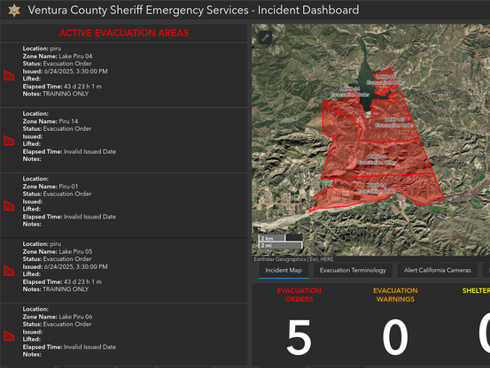
Ventura County evacuations as of 8/7/25 1431, there are also LA County evacs. https://vcoes.maps.arcgis.com/apps/dashboards/e15ca0d2737d43cea6514043e61f1a7c 8/7/25 1431 #CanyonFire #Piru #CAwx #wildfires #VenturaCounty #LosAngelesCounty
Requesting 2 addl Type I air tankers 8/7/25 1436 #CanyonFire #Piru #CAwx #wildfires #VenturaCounty #LosAngelesCounty
Eastern control objective has been moved to Chiquita Canyon. 8/7/25 1443 #CanyonFire #Piru #CAwx #wildfires #VenturaCounty #LosAngelesCounty
Current evacuations in Los Angeles County. 8/7/25 1446 #CanyonFire #LosAngelesCounty #evacuations #wildfires #CAwx
409 acres per FIRIS 8/7/25 1454 #CanyonFire #LosAngelesCounty #VenturaCounty #evacuations #wildfires #CAwx
Fire is moving East (towards Los Angeles County). 8/7/25 1455 #CanyonFire #LosAngelesCounty #VenturaCounty #evacuations #wildfires #CAwx
Fire is now 600 acres per incident command. 8/7/25 1506 #CanyonFire #LosAngelesCounty #VenturaCounty #evacuations #wildfires #CAwx
NEW Evacuation orders for San Martinez and Hasley Canyon requested by air attack. 8/7/25 1408 #CanyonFire #LosAngelesCounty #VenturaCounty #evacuations #wildfires #CAwx #Piru
"This is an emergency message from VC Alert regarding a brush fire in your area. Your neighborhood is now under an evacuation warning due to potential threat of fire. Should conditions worsen, an evacuation order will be issued. Please prepare your personal belongings including valuables and pets and be ready to leave in a moment’s notice. For additional information, please visit www.vcemergency.com.
Este es un mensaje de emergencia de la Oficina de Servicios de Emergencia del Alguacil del Condado de Ventura con respecto a un incendio de maleza en su área. Su vecindario se encuentra bajo una advertencia de evacuación debido a la amenaza potencial de incendio. Si las condiciones empeoran, se emitirá una Orden de Evacuación. Por favor, prepare sus artículos personales, incluyendo objetos de valor y mascotas, y esté listo para evacuar al momento de ser notificado. Para más información, visite www.vcemergency.com."
8/7/25 1511 #CanyonFire #LosAngelesCounty #VenturaCounty #evacuations #wildfires #CAwx #Piru
Current path of the air attack planes, helicopters working on the Canyon Fire, at 8/7/25 1513
#CanyonFire #LosAngelesCounty #VenturaCounty #evacuations #wildfires #CAwx #Piru
Requesting units to investigate Chiquita Canyon for fire activity. 8/7/25 1520 #CanyonFire #LosAngelesCounty #VenturaCounty #evacuations #wildfires #CAwx #Piru
View of CanyonFire on Whitaker Peak Camera.
https://ops.alertcalifornia.org/cam-console/2601
8/7/25 1524 #CanyonFire #LosAngelesCounty #VenturaCounty #evacuations #wildfires #CAwx #Piru
Fire has spotted north of Lecter Motorway per units on scene. They're asking if it's still S. of Hasley Canyon
8/7/25 1526 #CanyonFire #LosAngelesCounty #VenturaCounty #evacuations #wildfires #CAwx #Piru
"Fire is going to bump Hasley Canyon"
8/7/25 1528 #CanyonFire #LosAngelesCounty #VenturaCounty #evacuations #wildfires #CAwx #Piru
Div M. says spot fires are between Oaks and Hasley Canyon, has not jumped Hasley. 8/7/25 1532 #CanyonFire #LosAngelesCounty #VenturaCounty #evacuations #wildfires #CAwx #Piru
Request for CHP to shut down traffic into Chiquita Canyon from 126. 8/7/25 1533 #CanyonFire #LosAngelesCounty #VenturaCounty #evacuations #wildfires #CAwx #Piru
New evacuation waring for Los Angeles County
LEVEL Evacuation Warning EVACUATION
County: Los Angeles
Zone ID:CAS-INDUSTRY
https://protect.genasys.com/zones/US-CA-XLA-CAS-INDUSTRY
8/7/25 1528 #CanyonFire #LosAngelesCounty #evacuations #wildfires #CAwx #Piru
BC says first residence that will be impacted by fire when it crosses into Hasley Canyon is 31060 Hasley Canyon Road, they are assigning structure resources to about 6-7 ranches in the area. They are discussing strategy on how to address the risks and structure defense.
8/7/25 1553 #CanyonFire #LosAngelesCounty #evacuations #wildfires #CAwx #Piru
Location is here. They expect fire to back slowly down towards the area, and they are hoping to button up the fire along the road here, good road access.
8/7/25 1553 #CanyonFire #LosAngelesCounty #evacuations #wildfires #CAwx #Piru
Discussion of progress, they say solid retardant line on West, rocked out on North, missed the other status, but making good progress on the fire. Acreage 1051 acres per Intel 24. 8/7/25 1602 #CanyonFire #LosAngelesCounty #evacuations #wildfires #CAwx #Piru
Air Attack has requested 4 additional air tankers, any type. 8/7/25 1607 #CanyonFire #LosAngelesCounty #evacuations #wildfires #CAwx #Piru
@ai6yr Are you part of the evacuatiom warning?
@HumToTable Nope, fortunately. Quite a ways away but in our same county.
@ai6yr Fireguard is showing that the heat detections are moving NE. The last report at 3:05 shows some major growth.
The Whitaker Peak camera shows a good view:
@ai6yr Alt text: "Evacuation Warning
Date 08-07-2025 Time 21:09:33 UTC
© Zone ID: CAS-ROMERO
REASON
Evacuation Warning in effect due to wildfire.
Prepare to evacuate, leave now if you need more time. Heed guidance from local officials. Visit alertla.org for more info
DESCRIPTION
Potential threat to life and/or property. Those who require additional time to evacuate, and those with pets and livestock should leave now.
B SEVERITY
(A Critical
68 COUNTY
Los Angeles
LOCATION INFORMATION
ZONE BOUNDARIES (Zone ID: CAS-ROMERO)
Castaic High School
NORTH OF Hawkset Street
SOUTH OF Romero Canyon Road
EAST OF Gilmour Street, Lechler Fire Truck Trail
West of Ham Canyon Road Meadow Grass Drive"
Map of districts. CAS-ROMERO is highlighted:
"Evacuation Warning in effect due to wildfire. Prepare
to evacuate, leave now if you need more time. Heed.."
@ai6yr
Critical to keep the fire away from the Chiquita Canyon landfill, where a chemical fire has been burning for years
Critical to keep the fire away from the Chiquita Canyon landfill, where a chemical fire has been burning for years
@ai6yr Is it just me or does anytime a fire break out up there, that whole area gets evac's everytime?
@Intel_Earth It's hard to get in and out of there... unpaved roads.
@ai6yr Thats fair, I haven't been up in that area of VNC before so im not too familiar with it