"Eruption begins" by #Iceland RUV @RuvEnglish - Initial observations say #LitliHrutur eruption is small so far, similar to how 2021 started. But 2021 eruption changed and this could too. https://nyr.ruv.is/english/2023-07-05-eruption-begins-387050 #Fagradalsfjall #volcano🌋 #geology

#Iceland Member of Parliament Gisli Olafsson says this eruption site is again good for not threatening infrastructure & property. But he warns it's a far more strenuous hike. Tourists should consider their limits. https://twitter.com/gislio/status/1678470436948942860 #Fagradalsfjall #volcano🌋 #geology

"Magnús Tumi: eruption larger than previously thought and bigger than recent years" by @RUVEnglish - Revised estimate about #LitliHrutur eruption after aerial view, now appears initially bigger than 2021 & 2022. https://nyr.ruv.is/english/2023-07-10-magnus-tumi-eruption-larger-than-previously-thought-and-bigger-than-recent-years-387499 #Fagradalsfjall #Iceland #volcano🌋 #geology

Lava reported flowing both north & south of #LitliHrutur eruption fissures, mostly south. Topo maps confirm it's on the terrain divide. To the south is Meradalir, a valley which was covered in 2021 & 2022 lava. 3rd annual lava flow? #Fagradalsfjall #Iceland #volcano🌋 #geology
#Iceland Meteorological Office IMO has reduced #aviation color code for #Fagradalsfjall #volcano🌋 from red to orange after verifying the #LitliHrutur eruption is not producing ash. https://en.vedur.is/earthquakes-and-volcanism/volcanoes/vona-notifications/?nr=466 #aviation #avgeek #geology
#Iceland broadcaster RUV has moved their webcam from Litli-Hrutur South to Driffellshraun to view the eruption fissures that opened NE of #LitliHrutur on Monday. https://www.youtube.com/watch?v=_q1N4J5oTSE #Fagradalsfjall #volcano🌋 #geology

Litli-Hrútur eruption
#Iceland RUV also moved their Litli-Hrutur North webcam a little further north so it can see around the slopes of #LitliHrutur to some of the erupting fissures. Mt #Keilir in the background. Reykjavik is behind Keilir. https://www.youtube.com/watch?v=yJfiMhqLgTY #Fagradalsfjall #volcano🌋 #geology


Reykjanes - Norður
"Volcano erupts in #Iceland after weeks of earthquakes" by @CNN / @jessieyeung8 - Roads, trails and off-road access closed around #LitliHrutur eruption area due to life-threatening high volume of volcanic gases.😷 https://www.cnn.com/2023/07/11/europe/iceland-volcano-erupts-litli-hrtur-intl-hnk/index.html #Fagradalsfjall #volcano🌋 #geology
Visir webcam shows lava fountain from the erupting fissures at #LitliHrutur. A southbound lava flow marches like an army out of Mordor toward Meradalir, a valley already covered by 2021 & 2022 #Fagradalsfjall lava flows. https://www.youtube.com/watch?v=aJP-8kLa3N0 #Iceland #volcano🌋 #geology

LIVE - Iceland volcano - Eruption in Meradalir - View in front
"New Eruption: Bigger Than Previous Two, Less Powerful Today" by Reykjavik Grapevine - Initially #LitliHrutur eruption started 10-20x bigger than 2021/2022 with dangerous volcanic gas clouds, but has already decreased https://grapevine.is/news/2023/07/11/new-eruption-bigger-than-previous-two-less-powerful-today/ #Fagradalsfjall #Iceland #volcano🌋 #geology

"Eruption zone partly opens to walkers" by #Iceland RUV @RUVEnglish - The news #volcano🌋 tourists wanted. But the only developed trails/parking are near Grindavik from #Fagradalsfjall 2021 & 2022 eruptions. Prepare for a long hike🚶. https://www.ruv.is/english/2023-07-11-eruption-zone-partly-opens-to-walkers-387670 #geology #travel

#Iceland seismometer sensor "FAF" was disconnected temporarily to move it out of the path of the lava flow from #LitliHrutur. In the past webcams have been destroyed🔥 by lava when staff didn't act quickly to move them. (pardon the bird🐦 site link - poster didn't cross-post here) https://twitter.com/twinderseis/status/1678824356204408832 #Fagradalsfjall #volcano🌋 #geology

"Fall into a burning curtain of fire with fissure eruptions" by @USGSVolcanoes #California #Volcano🌋 Observatory talks about fissure eruptions like #Iceland #LitliHrutur where lava erupted from faults & cracks. It occurs here too. https://www.usgs.gov/observatories/calvo/news/fall-a-burning-curtain-fire-fissure-eruptions #Fagradalsfjall #geology
Fall into a burning (curtain) of fire with fissure eruptions | U.S. Geological Survey
If you've been following the latest geological news, you'll have noticed the brand new eruption on Iceland's Reykjanes Peninsula. It's a classic example of an eruption of relatively fluid lava simultaneously at multiple points along a fissure in the earth, resulting in "curtains of fire". These fascinating phenomena provide a spectacular glimpse into the geologic processes driving eruptions.
"Earth's newest 'baby' volcano is painting #Iceland's #Fagradalsfjall region with incandescent lava" by @LiveScience - summary of the eruption at #LitliHrutur so far and the 7-day quake swarm that led up to it https://www.livescience.com/planet-earth/volcanos/earths-newest-baby-volcano-is-painting-icelands-fagradalsfjall-region-with-incandescent-lava #volcano🌋 #geology

"Keep calm" he says... That's easy to say when the #volcano🌋 erupting 20-30km away in view of the capital city is a shield volcano. They don't explode like the ones around here in the Pacific Rim. https://twitter.com/valurgr/status/1679096301336526849 #LitliHrutur #Fagradalsfjall #Iceland #geology

Remarkable footage. A drone operator in #Iceland found what we were all looking for. There wasn't a webcam in the right place. But he got it. Cracks opened, smoked and video of the first lava emerging. (link to bird site because I can't find the same content on Mastodon) https://twitter.com/WxNB_/status/1679251403569524737 #LitliHrutur #Fagradalsfjall #Iceland #geology

Nahel Belgherze on Twitter
“This is hands down one of the rarest volcano footage I’ve ever seen and possibly the first and only drone shot in the world showing a volcanic fissure opening up in real time. This was captured in Iceland two days ago by Jakob Vegerfors - shared with his permission.”
Webcam snapshot of #LitliHrutur eruption in #Iceland with sunrise 😎 lighting from behind the camera. https://www.livefromiceland.is/webcams/litlihrutur #Fagradalsfjall #volcano🌋 #geology

Litli-Hrútur eruption - Live from Iceland - Webcams around Iceland
The eruption by Litli-Hrútur near the Fagradalsfjall and Meradalir eruptions started monday the 10th of July at 16:40. Watch live feeds from our webcams with spectacular views of Iceland. Our streaming cameras are placed all around Iceland and broadcast 24/7. The ultimate slow TV!
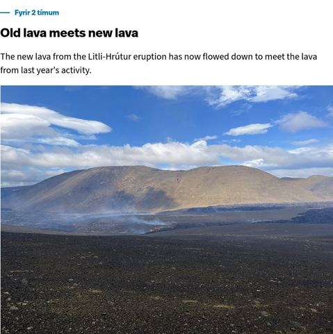
"Old lava meets new lava" by @RUVEnglish - New 2023 #LitliHrutur lava flow reaches 2021/2022 lava flows in #Meradalir. Remarkable ~1.6mi/2.6km lava flow in first 4 days of the eruption. It took months in 2021. https://www.ruv.is/english/2023-07-11-litli-hrutur-eruption-live-news-387570 #Fagradalsfjall #Iceland #volcano🌋 #geology

Litli-Hrútur eruption: live news - RÚV.is
This is the RÚV English live blog on the eruption at Litli-Hrútur - stay with us for the latest informationA lot of smoke is coming from the eruption and wildfires on the groundThe power and productivity of the volcanic eruption that began at Litli-Hrútur on the Reykjanes Peninsula on Monday has been significantly reduced. However, it has more power than the eruptions of recent yearsThe hiking trail to the site is closed - it will not reopen until, at the very earliest, Saturday, when a decision on that will be taken
Data from #LitliHrutur eruption as of July 13 by #Iceland Institute of Earth Sciences - graph in Icelandic & English; maps in Icelandic - "hraun" is Icelandic for lava and marks lava flows from 2021, 2022 & 2023. https://jardvis.hi.is/is/eldgos-vid-litla-hrut-nidurstodur-maelinga-13-juli #Fagradalsfjall #volcano🌋 #geology
When I get a chance to visit #Iceland, eruption is on #Fagradalsfjall east side. American #military #aviation #history on west side: 80 years ago, B-24 crash killed US Lt Gen Frank Andrews. He was traveling from Europe to DC for a promotion. After his loss, Dwight Eisenhower got the appointment to WWII Supreme Allied Commander originally intended for Andrews. https://en.wikipedia.org/wiki/Frank_Maxwell_Andrews

"Crater collapses and lava flows in a new direction" by @RUVEnglish - Spatter cone collapse redirected #LitliHrutur lava flow west. Previous south flows were speculated to endanger south coast highway within weeks. https://www.ruv.is/english/2023-07-19-crater-collapses-and-lava-flows-in-a-new-direction-388271 #Fagradalsfjall #Iceland #volcano🌋

The new configuration of the #LitliHrutur eruption with flow to the west side of the vent is putting on quite a show for the webcam (RUV @RUVEnglish Reykjanes North cam) https://www.youtube.com/watch?v=yJfiMhqLgTY #Fagradalsfjall #Iceland #volcano🌋
Reykjanes - Norður
"Iceland’s newest tourist attraction: a live volcanic eruption" by @FT / @MarkofDartmoor - Rush #travel to #Iceland to see new #LitliHrutur eruption. Wait for winds, then long hike and joined crowds at the erupting vent. (edit: hmmm... it shows the article when coming from the birb, but paywalls it when coming from Mastodon) https://www.ft.com/content/1e4f0091-0eed-48c9-b9c1-ea4ec3135ee5 #Fagradalsfjall #Iceland #volcano🌋
Watch for another crater wall collapse soon at #LitliHrutur since it has built up high unstable walls and filled with a small lava lake. Any webcam you prefer, one link here. Unknown which direction it will go. https://www.youtube.com/watch?v=yJfiMhqLgTY #Fagradalsfjall #Iceland #volcano🌋
Reykjanes - Norður
The expected crater rim collapse at #LitliHrutur was on the north side. Now out east instead of west side, flow remains south to Meradalir, convergence point of 2021, 2022 & 2023 lavas. Video by YT/volcanoimage: https://www.youtube.com/watch?v=u1si3ujow_s #Fagradalsfjall #Iceland #volcano🌋 #geology

WARNING! DO NOT CLIMB LILTI HRUTUR CONE-Vent collapse, lava overflow, dust devils. Update 7/24/2023
"Lava and Smoke Blanket #Fagradalsfjall" by @NASAEarth Observatory / @avoiland - Infrared satellite view of #LitliHrutur eruption just before it ended shows extent of lava flow south https://earthobservatory.nasa.gov/images/151653/lava-and-smoke-blanket-fagradalsfjall #Iceland #volcano🌋 #geology
"Litli-Hrútur eruption is over for now" by @icelandmonitor - slow decline of lava output since #LitliHrutur eruption began July 10. Lava output stopped Sun Aug 6. Another 3-week eruption like 2022. https://icelandmonitor.mbl.is/news/news/2023/08/06/the_litli_hrutur_eruption_is_over_for_now/ #Fagradalsfjall #Iceland #volcano🌋 #geology

"Iceland has entered a new volcanic era" by @NatGeo/@SquigglyVolcano - Eruptions like 2023 #LitliHrutur recur because tectonic plates spread apart in #Iceland. Quakes & ground inflation will signal where & when next. https://www.nationalgeographic.com/environment/article/iceland-eruption-fiery-volcano-earthquakes #Fagradalsfjall #volcano🌋 #geology
"Another eruption possible before Christmas?" by @RUVEnglish - Similar terrain uplift as before previous eruptions at #Fagradalsfjall signals magma possibly rising for another one. No guarantee, but possible in weeks/months. https://nyr.ruv.is/english/2023-10-16-another-eruption-possible-before-christmas-394223 #Iceland #volcano🌋 #geology

"Earthquakes suggest magma on the move" by @RUVEnglish - Quake swarm and ground uplift NW of Mt Þorbjörn (pronounced thor-byorn) between Blue Lagoon tourist site & Grindavik town, within #Fagradalsfjall volcanic region. https://www.ruv.is/english/2023-10-31-earthquakes-suggest-magma-on-the-move-395403 #Iceland #volcano🌋 #geology

"Blue Lagoon Closes Amid Earthquakes, Eruption Concerns" by @RVKgrapevine - Blue Lagoon iconic tourist site closes for a week amid increasing terrain uplift and earthquakes pointing to possible #volcano🌋 fissure eruption. https://grapevine.is/news/2023/11/09/blue-lagoon-closes-amid-earthquakes-volcanic-concerns/ #Fagradalsfjall #Iceland #geology

"Keflavik Airport at risk due to upcoming volcanic eruption" by #Iceland Flugblogg - Possible #volcano🌋 eruption on Reykjanes Peninsula threatens power & water supply to #KEF/#BIKF Airport. https://flugblogg.is/2023/11/09/keflavik-airport-at-risk-due-to-upcoming-volcanic-eruption/ #aviation #avgeek #travel #Fagradalsfjall #Iceland #geology

#Iceland #volcano🌋 emergency: Grindavik town (population 4000) evacuation ordered as magma dike estimated under the town. #Fagradalsfjall eruptions since 2021 have started when and near but not exactly where estimated. @rvkgrapevine article: https://grapevine.is/news/2023/11/10/updates-state-of-emergency-declared-grindavik-residents-flee/ #geology

Pictures by #Iceland @RUVEnglish / @RUVohf of cracks in the golf course as shallow quakes cause damage across Grindavik and threaten a new #volcano🌋fissure eruption. Quakes moved north of town along the magma dike's line after these pictures. https://www.ruv.is/english/2023-11-10-magma-tunnel-lies-under-grindavik-live-396249 #geology

Magma tunnel lies under Grindavík - LIVE - RÚV.is
A magma corridor lies under the town of GrindavíkA fissure could open anywhere in that magma corridorThe town has been evacuated. The evacuation was announced at midnightCivil Defence declared a Level of DangerEmergency responders were called out of Grindavík around 4amResidents who left Grindavík yesterday are asked to call the Red Cross on phone 1717 and register their departureA natural disaster expert makes it clear that this is a very large event
Latest IMO (#Iceland Met Office) estimate of rising underground magma dike line where new #volcano🌋 fissure eruption is likely. Though near 2021-2023 #Fagradalsfjall eruptions, this is in #Reykjanes volcanic region, also on mid-Atlantic Ridge. https://en.vedur.is/about-imo/news/a-seismic-swarm-started-north-of-grindavik-last-night #geology
"#Drone ban near #Grindavík" by #Iceland airports & ATC operator @Isavia - Airspace priority reserved for emergency services during precautionary #Reykjanes #volcano🌋 evacuation in the area. https://www.isavia.is/en/corporate/news-and-media/news/drone-ban-near-grindavik #geology #aviation #avgeek

Pics of the ground displacement & damage in #Grindavik are distressing for effects on the residents. Decades ago I experienced volcanic quakes at Mt Shasta in California, many shallow quakes, one strong enough that we braced yet wasn't felt at all 10mi away. We had no damage.
"Sky over the possible eruption site is now closed" by Flugblogg #Iceland #aviation blog - NOTAM closure for VFR aircraft and drones clears #Reykjanes #volcano🌋 evacuation area for emergency responder priority use https://flugblogg.is/2023/11/12/the-sky-over-the-possible-eruption-site-is-now-closed/ #pilot #drone #avgeek

"Severe Road Damage In Grindavík Following Earthquakes" by @RvkGrapevine - Shallow quakes from #Reykjanes #volcano🌋 threatening to erupt has opened cracks and caused damage across #Grindavik town as magma remained at estimated 800m/2500ft underground https://grapevine.is/news/2023/11/13/severe-road-damage-in-grindavik-following-earthquakes/ #Iceland #geology

"Sudden evacuation in Grindavík" by @icelandmonitor - Residents retrieving belongings were re-evacuated. Measured volcanic gas sulphur dioxide in the air in #Grindavik indicates magma at very shallow depth. https://icelandmonitor.mbl.is/news/news/2023/11/14/sudden_evacuation_in_grindavik/ #Reykjanes #Iceland #volcano🌋 #geology

"The Mystery of Iceland’s Non-Erupting Volcano" by @WIRED / @SquigglyVolcano - Previous eruptions at #Fagradalsfjall since 2021 also paused after magma was detected at shallow depth before eruption began. It could be happening again. https://www.wired.com/story/iceland-volcano-explode-eruption-when/ #Reykjanes #Iceland #volcano🌋 #geology

"Aviation code changed to yellow" by @IcelandMonitor - #Iceland's #Reykjanes #volcano🌋 has been threatening to erupt for 2 weeks but hasn't started. Without increasing probability, #aviation hazard color code dropped from orange to yellow. https://icelandmonitor.mbl.is/news/news/2023/11/24/aviation_code_changed_to_yellow/ #travel #avgeek

"Volcanic eruption has started" by MBL @IcelandMonitor - New fissure eruption in #Reykjanes region north of #Grindavik. Evacuation reinstated. Infrastructure threatened so not a tourist eruption like 2021-2023 #Fagradalsfjall. https://icelandmonitor.mbl.is/news/news/2023/12/18/volcanic_eruption_has_started/ #Iceland #volcano🌋 #geology

#Iceland Meteorological Office IMO downgraded #Reykjanes #volcano🌋 #aviation color code to orange after briefly setting it at red. The lava fountains are not producing ash. North Atlantic air #travel unimpeded. Approximate coordinates included. https://en.vedur.is/earthquakes-and-volcanism/volcanoes/vona-notifications/?nr=495 #geology
Live webcams were ready in the right area to capture new eruption. Here's one direct from a source (and not on YT). Due to short 4-hour winter days at 63N near Arctic Circle, expect helicopter footage to be rare. https://www.livefromiceland.is/webcams/fagradalsfjall #Iceland #Reykjanes #volcano🌋 #geology

Sundhnúkar - Live from Iceland - Webcams around Iceland
Looking towards the eruption near Sundhnúkagígar, north of Grindavík, from Mt. Þorbjörn. The eruption started December 18th at 22:17:17. Watch live feeds from our webcams with spectacular views of Iceland. Our streaming cameras are placed all around Iceland and broadcast 24/7. The ultimate slow TV!
"Eruption Has Begun At Sundhnúkagígar, Emergency/Distress Phase Announced" by Reykjavik Grapevine - Estimated location appears in "worst possible" place where it threatens power plant, hot water pipeline (in winter) & road https://grapevine.is/news/2023/12/18/eruption-has-begun-at-sundhnukagigar/ #Iceland #Reykjanes #volcano🌋 #geology

My post with the updated eruption location (63.887N, 22.372W) was supposed to be in this thread... https://avgeek.social/@ikluft/111605735939489708

Ian Kluft ✈️🎈🌋 (@[email protected])
Attached: 2 images Helicopter observations updated #Reykjanes #volcano🌋 eruption to 4km/2.5mi fissure centered at 63.887N, 22.372W. This is many times bigger than 2021-2023 #Fagradalsfjall eruptions. https://en.vedur.is/earthquakes-and-volcanism/volcanoes/vona-notifications/?nr=497 #Iceland #geology
"Isavia opens area over the new #volcano🌋 eruption for sightseeing flights" by Flugblogg #Iceland #aviation blog - Air corridors intended to manage newly-congested airspace as eruption area reopens for VFR flights https://flugblogg.is/2023/12/19/isavia-opens-area-over-the-new-volcano-eruption-for-sightseeing-flights/ #geology #pilot #avgeek #travel

"Iceland Erupts" by @NASAEarth Observatory - #NOAA infrared satellite imagery shows heat from the fissure eruption when it began in #Reykjanes region of #Iceland on Dec 19 https://earthobservatory.nasa.gov/images/152227/iceland-erupts #volcano🌋 #geology
"Eruption is cautiously declared over" by #Iceland @RUVEnglish / @RUVohf - Volcanologists have seen this before where an eruption starts big, releases its energy at once and ends in days. But new fissure vents could open. https://www.ruv.is/english/2023-12-21-eruption-is-cautiously-declared-over-400506 #Reykjanes #volcano🌋 #geology

"Iceland" by @XKCD comic - #Iceland has such interesting #geology that XKCD imagines a #SciFi committee designing it this way https://xkcd.com/2874/

"Grindavik HIt With Lava - Irreparable Damage and Sadness - Terrible Scenario" by Just Icelandic on YT - new eruption fissure opened next to historic Grindavik town https://www.youtube.com/watch?v=tsDBgjgEtnU&t=249 #Grindavik #Reykjanes #Iceland #volcano🌋 #geology

Grindavik HIt With Lava - Irreparable Damage and Sadness - Terrible Scenario
"Lava Reaches Grindavík, Claims First Homes" by Reykjavik Grapevine - First house lost to lava flow in #Grindavik was newly built. Unknown how long the eruption will last. https://grapevine.is/news/2024/01/14/eruption-has-begun-north-of-grindavik/ #Reykjanes #Iceland #volcano🌋 #geology

"Volcanic eruption resumes near Grindavík but stops within the town" by @LavaCentre - Eruption slowing; lava flow from vent next to #Grindavik town stopped after destroying 3 houses https://lavacentre.is/volcanic-eruption-resumes-near-grindavik/ #Reykjanes #Iceland #volcano🌋 #geology

"Another Eruption in Iceland" by @NASAEarth Observatory / @avoiland - #NASA Terra satellite imagery of plume from another brief eruption on #Iceland #Reykjanes peninsula https://earthobservatory.nasa.gov/images/152428/another-eruption-in-iceland #volcano🌋 #geology
"Volcano Watch 2024: Lava vs Infrastructure" by @RVKGrapevine - Jon & Art show where the Feb 8 lava flow crossed the main highway near Blue Lagoon & power plant; hot water used to heat houses also out at KEF Int'l Airport https://www.youtube.com/watch?v=CWJt03w-1rQ #Reykjanes #Iceland #volcano🌋 #geology

Volcano Watch 2024: Another Eruption, Lava Damages Road to The Blue Lagoon, Cuts Water Supply
Iceland can make a new twist on an old joke...
Q: Why did the lava flow cross the road?
A: What road?
"Completed building the road over the lava" by @IcelandMonitor - 3 days after Feb 8 eruption, road to Grindavik rebuilt; hot water pipeline restored heating at Njarðvík & Keflavik Int'l Airport #BIKF. https://icelandmonitor.mbl.is/news/news/2024/02/11/completed_building_the_road_over_the_lava/ #Reykjanes #Iceland #volcano🌋 #geology #aviation #travel

"Volcanic eruption on #Reykjanes Peninsula" by #Iceland @RUVEnglish - New eruption NE of Grindavik and east of Blue Lagoon, near December's eruption. Lava fountain and flows, no ash clouds, no #aviation/#travel disruption. https://www.ruv.is/english/2024-03-16-volcanic-eruption-on-reykjanes-peninsula-407479 #volcano🌋 #geology

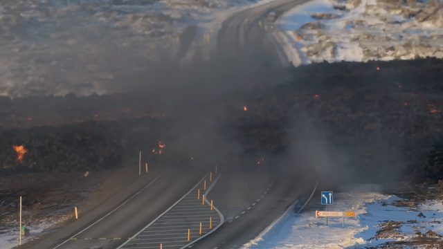
"Iceland volcano in pictures: Eruption spews lava and cuts off road" by @BBCWorld - Road north of #Grindavik overrun by lava flow, same as rebuilt in Feb. Lava levees protecting the town. Road to east threatened. https://www.bbc.com/news/world-europe-68598245 #Reykjanes #volcano🌋 #geology

"Volcano Watch 2024: Four Eruptions In Four Months" by @RvkGrapevine - Catharine (host/editor) and Art (camera/drone) show us around during a press visit to the lava flow front. The levee is diverting the slow-moving flow around #Grindavik town. https://www.youtube.com/watch?v=SCV9iFgRH0E #Reykjanes #Iceland #volcano🌋 #geology

Volcano Watch 2024: Four Eruptions In Four Months
 🇺🇦 🇵🇸
🇺🇦 🇵🇸@ikluft That made me lavalot

@ikluft this is perfect. “Well just like them on the volcanos” no notes!
@User47 While it's true in Iceland, there are also glaciers on volcanoes around the Pacific Rim. Unlike Iceland, Pacific Rim volcanoes are the explosive stratovolcanoes which have steep sides and build up to higher altitude, making up for lower latitudes. Examples in the Lower 48 states... in WA: Mt Baker, Glacier Peak, Mt Rainier, Mt St Helens; in OR: Mt Hood, Mt Jefferson, Three Sisters; in CA: Mt Shasta.
I’m glad the waterfall people chimed in too
@berndandeweg Good that the North Atlantic winter weather let them in!

@berndandeweg Then of course they returned to base. They had to get improved coordinates and estimated size of the eruption. So we spectators are not a priority.
@ikluft
I love Iceland eruptions because I can go 'yay, look at the lava!' without anyone being dead.
I love Iceland eruptions because I can go 'yay, look at the lava!' without anyone being dead.
@DrKylara Unfortunately we can already estimate this one is not a tourist eruption because it opened in a spot that threatens the geothermal power plant, hot water pipelines (for heating, which they want in winter), roads and the town of Grindavik. So the coverage will (or should) carry a more serious tone.
My graduate work was on the faults that made great earthquakes that caused major tsunamis offshore Japan and Sumatra. Normally when I sit up and think ‘cool earth science’, thousands of people are dead, which makes interest rather morbid and excitement very ghoulish. Infrastructure can be redesigned and rebuilt, though the impacts of infrastructure loss should not be minimized or ignored. I’m just glad when I can watch live video of the earth in motion without wondering whose last moments are captured in those images.
@DrKylara Understood. My interest in volcanoes & geology was driven by growing up on the flank of Mt Shasta. Even with the natural wonders to see there, I was one of relatively few locals who took classes at the local college to learn more about volcanoes.
Any of us who paid attention to the run-up to Reykjanes eruption already know the residents of Grindavik were evacuated to other parts of Iceland. We all need to double-check ourselves. Reporting & discussion OK. Enthusiasm needs restraint.
On a curious note, do you know who might be posting (or have posted in the past) about how the country would deal with the loss of lines/pipes from an engineering/technical perspective? I know I’ve seen posts/articles before about scenarios where an eruption cut off (or severely damaged) the main geothermal plant, but it’s been a long time (and presumably several technological advances) since then.
@DrKylara I saw this in the Reykjavik Grapevine last month. But it seems that until the eruption location became known today, there were more hypothetical scenarios than resources to deal with them all. They prioritized building a wall around the Svartsengi power plant, which was completed. And it looks like the eruption started outside the wall. https://grapevine.is/news/2023/11/08/preparations-underway-to-protect-hot-water-pipelines-amid-possible-eruption/

@ikluft better than a fake fireplace on the television, this year we get to have live volcano footage!