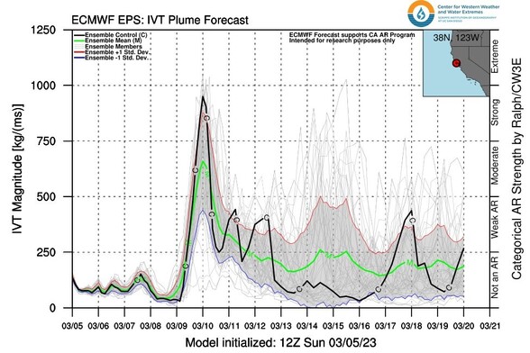
Are odds of warm #AtmosphericRiver storm in northern CA around 3/10-11 increasing? Yes. Are there related concerns because of near-record snowpack? Also yes. However, current operational model runs are *still near very upper end of their respective ensembles*.[1/5] #CAwx #CAwater
What does this mean? Right now, real world outcomes are still most likely to be less extreme than current control/operational runs are depicting. So a weak to moderate AR is more likely than a strong to very strong event. Strong consensus on timing around 2/10-2/11. [2/5] #CAwx
Even so, there is a rising chance of adverse impacts of *some* magnitude starting Fri/Sat. Early concerns: small stream/urban flood potential from rain/snowmelt *below 4,000ft.* Above about 4k feet, snowpack wiould likely absorb most rain without much melting. But... [3/5] #CAwx
With recent extreme snowfall at higher mountain elevations, there have already been reports of structural collapses from heavy snow loading. Any rain falling onto existing snow could rapidly increase loading via absorption of water, leading to further issues. [4/5] #CAwx
TL;DR: Odds of a warm storm of some magnitude around Fri/Sat are increasing, esp. NorCal, but magnitude and duration are highly uncertain. A modest event is most likely, but more severe storm can't be ruled out. Break in weather midweek a good time to prepare! #CAwx [5/5]