๐ŸŒ At Oslandia we have been working on a #3D #geospatial library for #web applications. It is #opensource, based on THREE.js and called Giro3D. Lots of new features described in this article :

https://oslandia.com/en/2023/02/09/les-nouveautes-sur-giro3d/
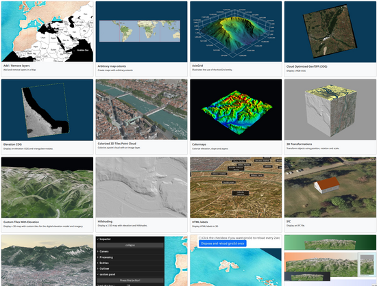
๐Ÿ‘‰ See the examples : https://giro3d.org/examples/index.html

๐ŸŽฎ You can also play with #CoG, #pointcloud data, BIM #IFC, #GIS Webservices and many types of data !

๐Ÿ‘ฉโ€๐Ÿ’ป We are looking for our next 3D engineer, see offer and apply here : https://oslandia.com/en/equipe/

Giro3D: whatโ€™s new?

The project has been swarming lately, so it's time for us to give you a little summary of everything that's been happening over the past few months! What is Giro3D? Giro3D is a 3D visualization library for web browsers, written in javascript and WebGL. Giro3D is based on THREE.js, leveraging all t

Oslandia
@vpicavet Any #OpenStreetMap importers already?
@blub It depends what / how you will visualize. You can already use OSM base layers or vector tiles layers draped on a DTM ( see e.g. Mapbox example ).
OSM does not have 3D geometry. Elaborate 3D buildings would have to be converted from OSM semantics to geometry somehow, we could implement that in #PostGIS or #py3dtiles for example .
Next feature coming to #Giro3D is in-browser 2D->3D extrusion for WFS, could be usable for 2D OSM data too. @autra
@vpicavet @autra yeah I was thinking about simple3dbuildings, micomapping etc 
@blub @vpicavet one precision : giro3d is a js/webgl lib, not a full app. As such, it does not have the notion of "importers". Our goal is to support every standard protocol, so that you can use your other open-source backend server with it (simple xyz tiles, openmaptiles, pg_tileserv etc...)