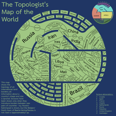
Really charming "topologists world map."

Forget size or position, this map *only* shows which countries border which other countries: http://tafc.space/qna/the-topologists-world-map/

The topologist’s world map – tafc.space

@elizayer nice, but the denmark-canada border is missing.
@yetzt @elizayer
There is no such border as it is water only. Unless that counts, because apparently DK also borders with SE according to this graph, which is also only sea.

@dvdhaven canada and denmark have a land border on hans island as of last year.
https://en.wikipedia.org/wiki/Hans_Island

but i see the graph is from 2020.

Hans Island - Wikipedia

@yetzt @dvdhaven Yes, after so many years of simmering tensions we finally made peace without firing a shot (unless you count schnapps and whisky 😄).
@dvdhaven @yetzt @elizayer The border between Denmark and Sweden is shown as blue, similar to the one between UK and France. It could mean they're connected via bridge or tunnel (which they are, also in 2020), which would have to have a non-sea border somewhere along it.
@dvdhaven @yetzt @elizayer The DK-SE border is maybe shown as a land connection because of the Öresund Bridge.
@yetzt @elizayer So is the French Brazilian one. 🤓
@schm at least the french-dutch border is present.
@yetzt am I missing something? I don't see it in the "map".
@schm @yetzt I think the French-Brazilian border is represented as one of the "exclaves" - the one-letter F bordering Brazil represents France (but yes, detaching exclaves does decrease the full force of the exercise!)

@elizayer @yetzt Oh. You're right my bad. I was hoping for a big connection from Europe to the Americas and didn't see any. I didn't notice the exclaves.

Now I also see the Dutch-French border on St. Martin.

Thanks for the explanation.