The National Weather Service in Aberdeen issued an urgent weather message early Monday morning, warning of a heat advisory in effect from 1 PM this afternoon to 7 PM CDT this evening.
👉 Read here: https://www.mykxlg.com/news/local/heat-advisory-issued-for-south-dakota-counties-amid-rising-temperatures/article_b5ea8b3c-3224-11ef-85db-cb657372d011.html
🚨 A severe thunderstorm warning was issued for southwestern Roberts, southeastern Day, and northwestern Grant counties in SD until 6:30 AM CDT on Wednesday, June 12, 2024.
👉 READ more: https://zurl.co/siqi
#SDWeather #ThunderstormWarning #KXLGNews
#KXLGRadio #LiveandLocal
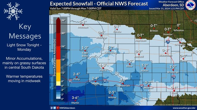
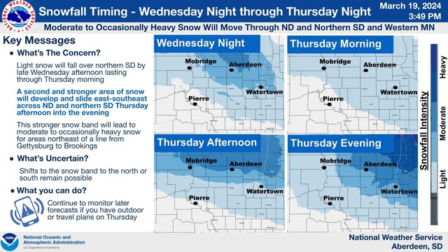
Light snow to persist through today and into Monday morning, with minor accumulations expected mainly on grassy surfaces in central SD. Warmer temperatures are forecasted for mid-week.
#SDweather #snowfall #winterforecast #KXLG #NWSAberdeen
@NWSAberdeen
#SDweather #snowfall #winterforecast #KXLG #NWSAberdeen
@NWSAberdeen

Severe winter storm conditions across South Dakota, causing snow-packed and ice-covered roads along Interstates 90 and 29. Accumulating snow, refreezing precipitation, and strong winds reported #SouthDakota #WinterStorm #KXLGNews #KXLG #weather #SDWeather
https://zurl.co/3U3G
https://zurl.co/3U3G
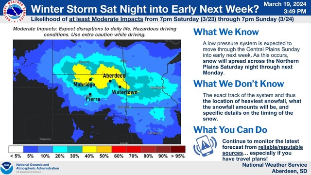
Here is the latest information concerning the upcoming storm system. Prepare and be safe. Hazardous travel conditions are expected! #NWSAberdeen #weather #sdweather #winterstorm
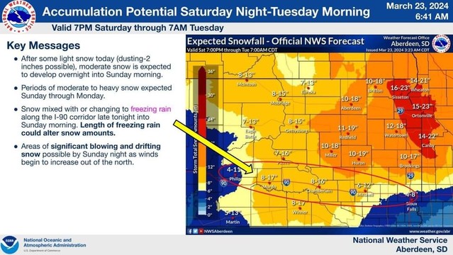
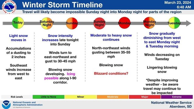
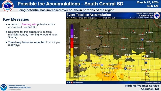
South Dakota is preparing for a severe winter storm as blizzard conditions are expected to hit portions of the state from Saturday evening through late Monday night. Stay safe and stay tuned to #KXLG for updates. #SDWeather #WinterStorm #travelsafe
https://zurl.co/wmN5
https://zurl.co/wmN5
City of Watertown's Street Maintenance division takes proactive measures to ensure road safety by initiating salt brine pre-treatment ahead of the predicted snowfall. #WinterSafety #KXLGNews #KXLG #SDWeather #SDNews #winterdriving #roadsafety
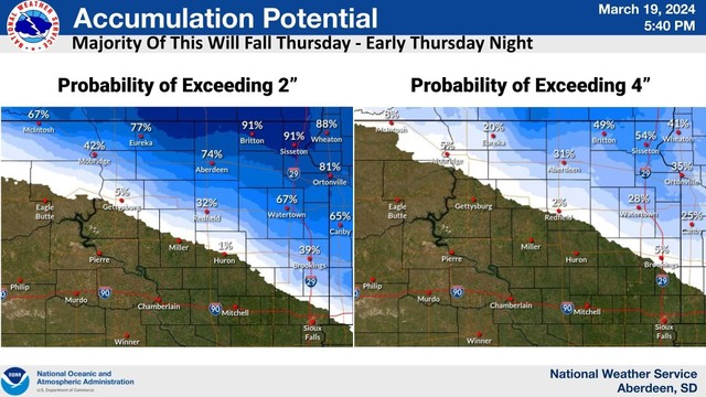
An update on some snowfall potentials. Most of the snow is expected to fall north and east of a line from McIntosh to Miller. Potentials have decreased slightly with the new forecast, but there is still a 20 to 50% chance of northeast SD receiving more than 4 inches. #SDweather
#SDwx #SDweather
192
FXUS63 KFSD 201740
AFDFSD
Area Forecast Discussion
National Weather Service Sioux Falls SD
1140 AM CST Tue Feb 20 2024
.KEY MESSAGES...
- Low (<30%) chance of patchy fog through daybreak.
- Above normal temperatures continue, perhaps rising even
further into early next week.
- Precipitation chances remain minimal with the main chance of
a sprinkle/very light precipitation late Wedn https://mesonet.agron.iastate.edu/p.php?pid=202402201740-KFSD-FXUS63-AFDFSD

#SDwx #SDweather
574
FXUS63 KUNR 201707
AFDUNR
Area Forecast Discussion For Western SD and Northeastern WY
National Weather Service Rapid City SD
1007 AM MST Tue Feb 20 2024
.KEY MESSAGES...
136 AM MST Tue Feb 20 2024
- Dry and mild conditions will persist through the week
&&
.DISCUSSION...(Today Through Monday)
Issued at 136 AM MST Tue Feb 20 2024
Current WV imagery depicts plume of upper level moisture
a https://mesonet.agron.iastate.edu/p.php?pid=202402201707-KUNR-FXUS63-AFDUNR
