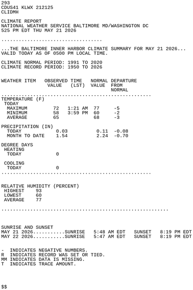
BALTIMORE INNER HARBOR May 21 Climate Report: High: 72 Low: 58 Precip: 0.03" Snow: Missing
https://mesonet.agron.iastate.edu/p.php?pid=202605212125-KLWX-CDUS41-CLIDMH
BALTIMORE INNER HARBOR May 21 Climate Report: High: 72 Low: 58 Precip: 0.03" Snow: Missing
https://mesonet.agron.iastate.edu/p.php?pid=202605212125-KLWX-CDUS41-CLIDMH
The Storm Prediction Center issues Day 1 Marginal Convective Risk at May 21, 19:56z for portions of LWX
https://www.spc.noaa.gov/products/outlook/archive/2026/day1otlk_20260521_2000.html
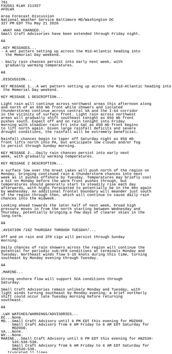
LWX issues Area Forecast Discussion (AFD) at May 21, 3:27 PM EDT
https://mesonet.agron.iastate.edu/p.php?pid=202605211927-KLWX-FXUS61-AFDLWX
The Weather Prediction Center issues Day 1 Marginal Risk Excessive Rainfall Outlook at May 21, 15:53z for portions of LWX
https://www.wpc.ncep.noaa.gov/qpf/excessive_rainfall_outlook_ero.php
The Storm Prediction Center issues Day 1 Marginal Convective Risk at May 21, 16:15z for portions of LWX
https://www.spc.noaa.gov/products/outlook/archive/2026/day1otlk_20260521_1630.html
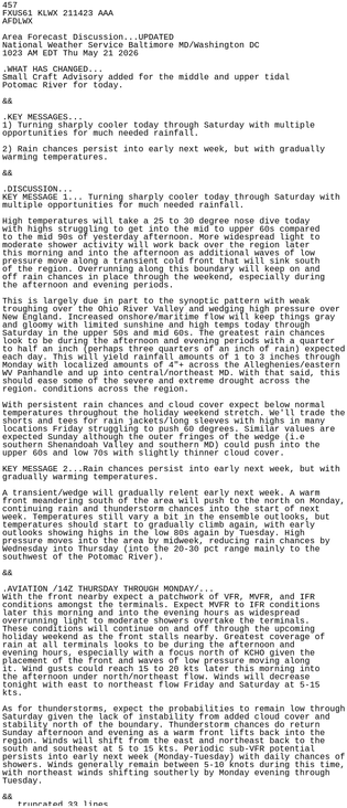
LWX issues Area Forecast Discussion (AFD) at May 21, 10:23 AM EDT
https://mesonet.agron.iastate.edu/p.php?pid=202605211423-KLWX-FXUS61-AFDLWX-AAA
The Storm Prediction Center issues Day 1 Marginal Convective Risk at May 21, 12:50z for portions of LWX
https://www.spc.noaa.gov/products/outlook/archive/2026/day1otlk_20260521_1300.html
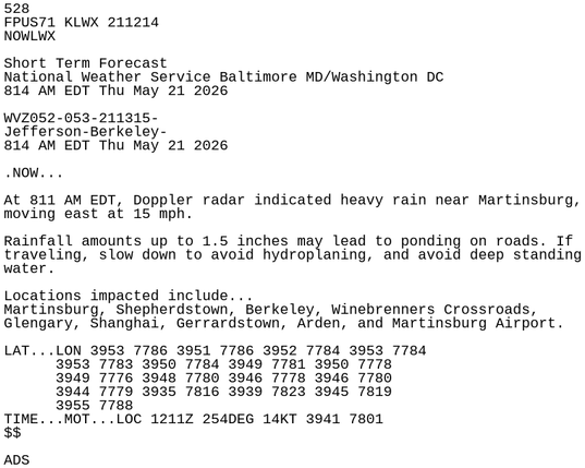
LWX issues Short-term Forecast (NOW) at May 21, 8:14 AM EDT
https://mesonet.agron.iastate.edu/p.php?pid=202605211214-KLWX-FPUS71-NOWLWX
[Delayed Report] 3 NW Earlysville [Albemarle Co, VA] Trained Spotter reports Tstm Wnd Dmg at 20 May, 3:45 PM EDT -- Spotter reported multiple trees down near Buck Mountain Road and Markwood/Simmons Gap Roads.
https://mesonet.agron.iastate.edu/lsr/?by=wfo&wfo=LWX&sts=202605201945&ets=202605201945
[Delayed Report] Earlysville [Albemarle Co, VA] Trained Spotter reports Tstm Wnd Dmg at 20 May, 3:45 PM EDT -- Spotter reported downed trees and large limbs near Buck Mountain Road and Link Evans Road.
https://mesonet.agron.iastate.edu/lsr/?by=wfo&wfo=LWX&sts=202605201945&ets=202605201945