How can we image the dip of distributed fault zones with seismicity?
Read how Ross extracts the fault zone geometry: https://doi.org/10.26443/seismica.v3i1.1092
#faultstructure #hypocenter #Seismology #EarthquakeScience #peerreviewed #DiamondOpenAccess #Earthquake #OpenAccess #OpenScience
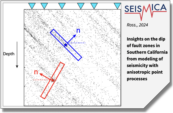

Insights on the dip of fault zones in Southern California from modeling of seismicity with anisotropic point processes
Accurate models of fault zone geometry are important for scientific and hazard applications. While seismicity can provide high-resolution point measurements of fault geometry, extrapolating these measurements to volumes may involve making strong assumptions. This is particularly problematic in distributed fault zones, which are commonly observed in immature faulting regions. In this study, we focus on characterizing the dip of fault zones in Southern California with the goal of improving fault models. We introduce a novel technique from spatial point process theory to quantify the orientation of persistent surficial features in seismicity, even when embedded in wide shear zones. The technique makes relatively mild assumptions about fault geometry and is formulated with the goal of determining the dip of a fault zone at depth. The method is applied to 11 prominent seismicity regions in Southern California. Overall, the results compare favorably with the geometry models provided by the SCEC Community Fault Model and other focused regional studies. More specifically, we find evidence that the Southern San Andreas and San Jacinto fault zones are both northeast dipping at seismogenic depths at the length scales of 1.0–4.0 km. In addition, we find more limited evidence for some depth dependent variations in dip that suggest a listric geometry. The developed technique can provide an independent source of information from seismicity to augment existing fault geometry models.