#CTP #PAwx 362
WWUS71 KCTP 081156
NPWCTP

URGENT - WEATHER MESSAGE
National Weather Service State College PA
756 AM EDT Fri May 8 2026

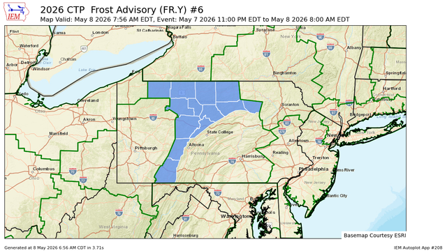
PAZ004>006-010>012-017-018-024-033-037-041-042-081300-
/O.EXP.KCTP.FR.Y.0006.000000T0000Z-260508T1200Z/
Warren-McKean-Potter-Elk-Cameron-Northern Clinton-Clearfield-
Northern Centre-Cambria-Somerset-Tioga-Northern Lycoming-Sullivan-
Including the cities of Mansfield, DuBois, Bradford, St. Marys,
Laporte, Ridgway, Clearfield, Trout Run, https://mesonet.agron.iastate.edu/vtec/f/2026-O-EXP-KCTP-FR-Y-0006_2026-05-08T11:56Z

KCTP Frost Advisory #6

Warren, McKean, Potter, Elk, Cameron, Northern Clinton, Clearfield, Northern Centre, Cambria, Somerset, Tioga, Northern Lycoming, Sullivan

Iowa Environmental Mesonet

#CTP #PAwx 934
FXUS61 KCTP 080949
AFDCTP

Area Forecast Discussion
National Weather Service State College PA
549 AM EDT Fri May 8 2026

.WHAT HAS CHANGED...
* Added fog N of I-80 for this morning
* Upped winds today a bit from guidance, most in the SE.
* Expanded frost mentions Mon night

&&

.KEY MESSAGES...
1) Persistent and digging upper low over central Canada and the
Upper Great Lakes will provide several shots of rain all through
the weekend.

2) High pressure ea https://mesonet.agron.iastate.edu/p.php?pid=202605080949-KCTP-FXUS61-AFDCTP

IEM :: AFD from NWS CTP

AFD issued by NWS CTP at 08 May 2026 09:49 UTC

#CTP #PAwx 844
AWUS81 KCTP 080920
RWSCTP
PAZ004>006-010>012-017>019-024>028-033>037-041-042-045-046-
049>053-056>059-063>066-082330-

Regional Weather Summary
National Weather Service State College PA
520 AM EDT Fri May 8 2026

A frost advisory is out until 8AM for portions of NW PA and the
Alleghenies. Patchy fog is also present in parts of N/NE PA, which
will likely burn away by around 9AM. High temperatures on Friday
will range from the mid 50s across the north, to https://mesonet.agron.iastate.edu/p.php?pid=202605080920-KCTP-AWUS81-RWSCTP

IEM :: RWS from NWS CTP

RWS issued by NWS CTP at 08 May 2026 09:20 UTC

#CTP #PAwx 634
FLUS41 KCTP 080749
HWOCTP

Hazardous Weather Outlook
National Weather Service State College PA
349 AM EDT Fri May 8 2026

PAZ019-025>028-034>036-045-046-049>053-056>059-063>066-090800-
Southern Centre-Blair-Huntingdon-Mifflin-Juniata-Bedford-Fulton-
Franklin-Southern Clinton-Southern Lycoming-Union-Snyder-Montour-
Northumberland-Columbia-Perry-Dauphin-Schuylkill-Lebanon-Cumberland-
Adams-York-Lancaster-
349 AM EDT Fri May 8 2026

This Hazardous Weather O https://mesonet.agron.iastate.edu/p.php?pid=202605080749-KCTP-FLUS41-HWOCTP

IEM :: HWO from NWS CTP

HWO issued by NWS CTP at 08 May 2026 07:49 UTC

#CTP #PAwx 268
FXUS61 KCTP 080715
AFDCTP

Area Forecast Discussion
National Weather Service State College PA
315 AM EDT Fri May 8 2026

.WHAT HAS CHANGED...
* Added fog N of I-80 for this morning
* Upped winds today a bit from guidance, most in the SE.
* Expanded frost mentions Mon night

&&

.KEY MESSAGES...
1) Persistent and digging upper low over central Canada and the
Upper Great Lakes will provide several shots of rain all through
the weekend.

2) High pressure ea https://mesonet.agron.iastate.edu/p.php?pid=202605080715-KCTP-FXUS61-AFDCTP

IEM :: AFD from NWS CTP

AFD issued by NWS CTP at 08 May 2026 07:15 UTC

#CTP #PAwx 574
CDUS41 KCTP 080624
CLIJST

CLIMATE REPORT
NATIONAL WEATHER SERVICE STATE COLLEGE PA
224 AM EDT FRI MAY 08 2026

...................................

...THE JOHNSTOWN CLIMATE SUMMARY FOR MAY 7 2026...

CLIMATE NORMAL PERIOD 1991 TO 2020
CLIMATE RECORD PERIOD 1892 TO 2026

WEATHER ITEM OBSERVED TIME RECORD YEAR NORMAL DEPARTURE LAST
VALUE (LST) VALUE VALUE FROM YEAR
https://mesonet.agron.iastate.edu/p.php?pid=202605080624-KCTP-CDUS41-CLIJST

IEM :: CLI from NWS CTP

CLI issued by NWS JST at 08 May 2026 06:24 UTC

#CTP #PAwx 576
CDUS41 KCTP 080624
CLIIPT

CLIMATE REPORT
NATIONAL WEATHER SERVICE STATE COLLEGE PA
224 AM EDT FRI MAY 08 2026

...................................

...THE WILLIAMSPORT PA CLIMATE SUMMARY FOR MAY 7 2026...

CLIMATE NORMAL PERIOD 1991 TO 2020
CLIMATE RECORD PERIOD 1895 TO 2026

WEATHER ITEM OBSERVED TIME RECORD YEAR NORMAL DEPARTURE LAST
VALUE (LST) VALUE VALUE FROM YEAR
https://mesonet.agron.iastate.edu/p.php?pid=202605080624-KCTP-CDUS41-CLIIPT

IEM :: CLI from NWS CTP

CLI issued by NWS IPT at 08 May 2026 06:24 UTC

#CTP #PAwx 577
CDUS41 KCTP 080624
CLIBFD

CLIMATE REPORT
NATIONAL WEATHER SERVICE STATE COLLEGE PA
224 AM EDT FRI MAY 08 2026

...................................

...THE BRADFORD CLIMATE SUMMARY FOR MAY 7 2026...

CLIMATE NORMAL PERIOD 1991 TO 2020
CLIMATE RECORD PERIOD 1957 TO 2026

WEATHER ITEM OBSERVED TIME RECORD YEAR NORMAL DEPARTURE LAST
VALUE (LST) VALUE VALUE FROM YEAR
https://mesonet.agron.iastate.edu/p.php?pid=202605080624-KCTP-CDUS41-CLIBFD

IEM :: CLI from NWS CTP

CLI issued by NWS BFD at 08 May 2026 06:24 UTC

#CTP #PAwx 575
CDUS41 KCTP 080624
CLIMDT

CLIMATE REPORT
NATIONAL WEATHER SERVICE STATE COLLEGE PA
224 AM EDT FRI MAY 08 2026

...................................

...THE HARRISBURG PA CLIMATE SUMMARY FOR MAY 7 2026...

CLIMATE NORMAL PERIOD 1991 TO 2020
CLIMATE RECORD PERIOD 1888 TO 2026

WEATHER ITEM OBSERVED TIME RECORD YEAR NORMAL DEPARTURE LAST
VALUE (LST) VALUE VALUE FROM YEAR
https://mesonet.agron.iastate.edu/p.php?pid=202605080624-KCTP-CDUS41-CLIMDT

IEM :: CLI from NWS CTP

CLI issued by NWS MDT at 08 May 2026 06:24 UTC

#CTP #PAwx 578
CDUS41 KCTP 080624
CLIAOO

CLIMATE REPORT
NATIONAL WEATHER SERVICE STATE COLLEGE PA
224 AM EDT FRI MAY 08 2026

...................................

...THE ALTOONA CLIMATE SUMMARY FOR MAY 7 2026...

CLIMATE NORMAL PERIOD 1991 TO 2020
CLIMATE RECORD PERIOD 1948 TO 2026

WEATHER ITEM OBSERVED TIME RECORD YEAR NORMAL DEPARTURE LAST
VALUE (LST) VALUE VALUE FROM YEAR
https://mesonet.agron.iastate.edu/p.php?pid=202605080624-KCTP-CDUS41-CLIAOO

IEM :: CLI from NWS CTP

CLI issued by NWS AOO at 08 May 2026 06:24 UTC