Et si on jouait à reconstruire le monde ! 🟩

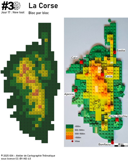
Le tracé des courbes de la Corse été simplifié, pour recréer la carte en relief, bloc par bloc, avec le plus de minutie possible. Alors, plutôt bien fait ? 😉

(Avez-vous trouvé le 💶 ?)

Découvrez toutes les cartes de nos agents : https://www.ign.fr/mag/30DayMapChallenge-30-jours-30-cartes-pour-celebrer-la-creativite-cartographique?fbclid=IwY2xjawN6sXRleHRuA2FlbQIxMABicmlkETF4YllVUW5HbUlzbGplOW9Bc3J0YwZhcHBfaWQQMjIyMDM5MTc4ODIwMDg5MgABHiO_PBSRhN03gVAFSu1tqEF7knuY8SwTtF2cdbBQPKSmY4pywUg-J4jAL-a0_aem_kuSqnW_1bD-H5pKS7XyTYg

#30DayMapChallenge – J17 #ANewTool
✍️ Marie Stretti
✍️ Maureen Chatel

#30DayMapChallenge #aNewTool #rstats #spanishoddata ( https://ropenspain.github.io/spanishoddata/ ) meets #mapgl and #flowmapper to show differences between daily home-work-home trips and all other frequent and infrequent trips in Barcelona.

Not only trying a new tool (#mapgl #rstats, thanks to https://github.com/walkerke), but also contributing to a new tool (#rstats #flowmapper, thanks to https://github.com/JohMast).

Get Spanish Origin-Destination Data

Gain seamless access to origin-destination (OD) data from the Spanish Ministry of Transport, hosted at <https://www.transportes.gob.es/ministerio/proyectos-singulares/estudios-de-movilidad-con-big-data/opendata-movilidad>. This package simplifies the management of these large datasets by providing tools to download zone boundaries, handle associated origin-destination data, and process it efficiently with the duckdb database interface. Local caching minimizes repeated downloads, streamlining workflows for researchers and analysts. Extensive documentation is available at <https://ropenspain.github.io/spanishoddata/index.html>, offering guides on creating static and dynamic mobility flow visualizations and transforming large datasets into analysis-ready formats.