Interceptor Sewers: the thread about Victorian efforts to clean up the Water of Leith

  • The first part of Edinburgh’s sewage history covered the East Foul Burn and the Irrigated Meadows.
  • The second part of Edinburgh’s sewage history looked at the sewage problems of the Victorian city and how to fix them
  • At the end of part 2 of this story, Edinburgh and Leith (separate burghs at this time) had finally agreed the terms of an “Interceptor Sewer” for the Water of Leith. What is an Interceptor Sewer? It is a sewer that “intercepts” other sewers and collects their output before it can discharge some place else; in this case into the river of the Water of Leith. This sewer could intercept all the untreated human and animal waste that was currently discharging into the river and carry it safely off somewhere else, out of sight and out of mind. The construction of the interceptor sewer began immediately after approval of the parliamentary bill in 1864, and took 3 years to complete. The engineers were David and Thomas Stevenson.

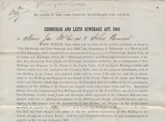
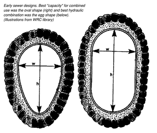
    A tax assessment for the contribution towards the construction of the Interceptor Sewer under the terms of the Edinburgh and Leith Sewerage Act, 1864

    The 1864 Interceptor as we shall call it comprises some 5.2 miles (8.4km) of brick-built, egg-shaped sewer. This is the optimum shape for a sewer, ensuring good flow at low volumes, being “self scouring” and requiring a less wide excavation than a circular sewer of the same cross-sectional area.

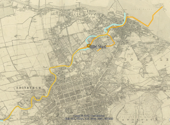
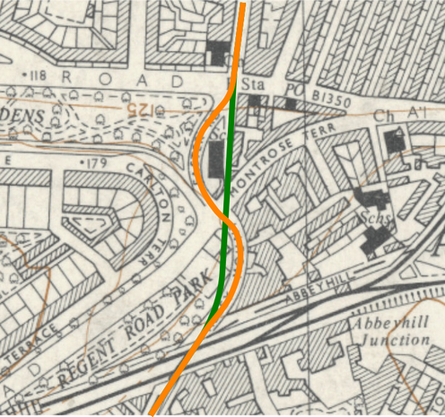
    Egg-shaped (left) vs. oval-shaped (right) sewer cross-sections

    The interceptor follows the course of the Water of Leith, from the “irrigated meadow” at Roseburn park – where the Lochrin Burn discharged the waste of the south west of the city – to the Black Rocks off of Leith. It runs along the river banks in places and along the river bed itself in others. An exception is near Bonnington in Leith where it takes a more direct route, directly under the industries which had been using the river as their sewer.

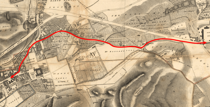
    Route of the 1864 Interceptor Sewer, overlaid on contemporary Ordnance Survey map.

    The sewer intercepted some 180 outflows into the river by the method shown below, which meant the old sewers would still overflow into the river during storm events, the internal weir directed most of the waste into the main interceptor. The interceptor got larger as it went downstream to account for the progressively increased volume of waste being added to it.

    Cross-section diagram of how the sewer intercepts the old outflows along the riverSewer overflow of the 1864 Interceptor at the Coalhill in Leith

    The brick-built interceptor is around 2.5 feet wide (I couldn’t find a precise measure), with some sections between 2 and 3 feet wide of cast iron pipe, and where it hits the Shore at Leith (picture above) it becomes a 3 foot 6″ pipe, set 20 feet back from the quayside. It is ideally sited to take much of the waste of Leith (which historically either flowed into the river, or was directed towards the shore). The outflow was at a depth 17 feet below the high water spring tides, with the outflow generally being carried away down the Firth of Forth east by the tide. The cost of this scheme was “about £70,000 [£8.9M in current money], entailing a special drainage-rate of 2/6d per £ on the rental within the [catchment area]“.

    The pin marked “1864 vent” on the map refers to that curious, square-section “chimney” above the river weir in St. Mark’s Park. It’s not a chimney at all, but a “stink pipe” or sewer vent. Noxious gasses and air compressed by storm events can escape here.

    St. Mark’s Park 1864 sewer vent, CC-by-SA N. Chadwick via Geograph

    The 1864 Interceptor did exactly what it was designed to do, and was very successful at it. It was calculated to carry 600 cubic feet per minute at the outflow, but even by the time it was completed the requirement had more than doubled to 1,340 cubic feet as the population had exploded along its route; “in some cases fivefold“. So the additional waste from the city simply overtopped the collection weirs and continued to find its way into the river.

    There was also the continued problem of the waste collecting in the old mill lades at Coltbridge (Roseburn) and Stockbridge, and the same old story of reluctant owners and landlords and fragmented ownership making it very difficult to get anything done about these. In 1873, after nearly 10 years of to-and-fro, the “Edinburgh Improvement Trust” was ready to abandon trying to sort things out. Not even a “forceful petition from Stockbridge residents” having had the required effect. By 1884, a survey by the Trust found that the Coltbridge mill dam had accumulated behind it a 4 foot depth of solid, compacted human excrement and 7.5 feet depth of more liquid matter; the situation was intolerable.

    In 1885, the Edinburgh Corporation stepped in and had the Coltbridge mill lades and dam certified as a public health nuisance and obtained an order requiring the owners to clean it up. In the words of the Corporation’s presiding officer:

    A deposit of putrescent sewage and other decomposing organic matter [which] is continually evolving noxious gases and germs, of a nature to produce and provoke miasmatic and malarious disease, and to endanger the health of persons who reside in, or who have occasion to frequent the neighbourhood.

    Edinburgh’s preferred solution was to fill the mill lades and demolish the weirs below the Coltbridge to cause the river to flow better and scour itself, but leave the lower weir at Leith Mills as a sewage trap. Leith was of course less than pleased by this and the two councils went back to wrangling. The Edinburgh Improvement Act of 1887 gave the Corporation the powers of compulsory purchase along the Stockbridge “Great Lade” (marked brown on the map below). This power they exercised, causing the lade to be progressively bought up and filled in from 1891-1893.

    Course of the “Great Lade” through Stockbridge and Canonmills

    A more coordinated approach was required however; in addition to the burghs of Edinburgh and Leith, the Parishes of Colinton and Currie, the County of Midlothian, the Sewerage Commission, the Dock Commission, and the Edinburgh and District Water Trust all had an interest. It was Leith though, that really drove action, after all they were at the bottom of the river so subject to any sewage in the river from their upstream neighbours. They were ill-served by the over-capacity 1864 Interceptor and they were most directly dependent on the water for livelihood and prosperity. Leith Town Council commissioned a series of public health and sewerage reports in 1885 and 1886 to set out the problem and had the whole course of the river surveyed from the uppermost mill to the sea, to detail the causes.

    Edinburgh finally got on board with Leith, and together they commissioned a joint report in 1887 that proposed the construction of a duplicate interceptor sewer for the Water of Leith, along a longer course and with a much greater capacity. This sewer would remedy the shortcomings of the 1864 scheme and would serve to once and for all satisfy the requirements of both Edinburgh and Leith regards sewage disposal, and it was to be adequate for the next fifty years of expected growth in demand. Long-term thinking at last!

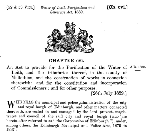
    And so it was that the Water of Leith Purification and Sewerage Act, 1889 (you can read the full provisions online, here, all 70 pages of them) went before parliament; opposed by 16 groups of petitioners, mainly mill owners and industries determined to protect their rights to abstract water from the river and discharge effluent into it.

    Preamble of the 1889 act

    The act passed, and work proceeded on an altogether grander scheme for the whole river, some 22.5 miles long, with a diameter increasing from 4 feet upstream to 9’3″ x 7’2″ downstream. The scheme also included a branch for The Stank, the burn cum drain cum sewer that drained the village of Corstorphine, and the marshy land and farms of the Gyle area into the Water of Leith at Roseburn.

    Route of the 1889 Interceptor marked in red, with the 1864 marked in yellow

    The 1889 Interceptor largely follows that of 1864 between Coltbridge and Stockbridge and the two are interconnected in places. At sections it takes a more direct shortcut, allowing the 1864 to continue to intercept the sewers at the river, while channelling the upstream waste by a more direct route to the sea. After Stockbridge the 1889 route heads away from the river to take a more direct route to the sea, running directly under Pilrig Park and Leith Links (where construction was easier), serving the expanding district between Edinburgh and Leith along Leith Walk.

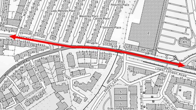
    Route of the 1889 Interceptor through Leith

    The vent for the 1889 sewer is behind St. Mary’s School on the Links, on the site of the old Roperie, It is another apparently isolated “chimney” and has always proved very hard to get a decent photo of! now that the 15 years and more of being hidden in a stalled building development it is much easier to access. I wonder if the residents of those fancy new townhouses realise what the public “feature” in front of their windows really is!

    The 1889 Interceptor vent off of Leith Links, now an architectural feature off Pillans Walk. Photo © Self

    The two sewers now served a catchment area that was where the city was expanding fastest, shown by the pale orange area in the map below (they also served much of South Leith)

    Late 19th century drainage catchment map of Edinburgh, the pale orange area had been served by the Water of Leith until the Interceptor Sewers took over.

    Long story short, the 1889 scheme was so successful that in 1896 the Edinburgh Corporation found itself needing to secure powers to pass by-laws to protect fishing rights in the river that only a few years before had been nothing but a stinking sewer! The river Purification Act had done exactly that. That said it was only the river which had been purified; the sewage was still entirely untreated and discharged directly into the Firth of Forth off the Black Rocks, where it joined by the effluent from the Old Town and the Southside of the city that flowed through the Irrigated Meadows system to enter the Firth of Forth at Fillyside. But that will be a further thread to cover the final part of this story.

    The last part of this story is the thread about the great untold engineering feat of Edinburgh’s 1970s Interceptor Sewers and the grand scheme to clean up the Firth of Forth.

    Note to readers: unfortunately in April 2026, a third-party plug-in more than exceeded its authority and broke many of the image links on this site. No images were lost but I will have to restore them page-by-page, which may take some time. In the meantime please bear with me while I go about rectifying this issue.

    If you have found this site useful, informative or amusing then you can help contribute towards its running costs by supporting me on ko-fi. This includes my commitment to keeping it 100% advert and AI free for all time coming, and in helping to find further unusual stories to bring you by acquiring books and paying for research.
    Or please do just share this post on social media or amongst friends and like-minded people, sites like this thrive on being shared.

    Explore Threadinburgh by map:

    Travelers' Map is loading...
    If you see this after your page is loaded completely, leafletJS files are missing.

    These threads © 2017-2026, Andy Arthur.

    NO AI TRAINING: Any use of the contents of this website to “train” generative artificial intelligence (AI) technologies to generate text is expressly prohibited. The author reserves all rights to license uses of this work for generative AI training and development of machine learning language models.

    #Lochend #Logan #Restalrig #StMargaret

    Misaligned: the thread about the origins of London Road

    I would like this morning to deal with a troubling subject. Why does London Road have an almost imperceptible kink in it through Abbeyhill? And while we’re at it, why is Lower London Road even a thing?

    London Road through Abbeyhill. Kinky.

    Let’s start with a little bit of background on London Road, which we’ve also covered some of already in the thread about the Regent Road and why it had to be built. The name is obvious in its derivation; it was the route into and out of Edinburgh to the east, and therefore also the south and ultimately to London. It was planned at the turn of the 19th century with the eminent Robert “Lighthouse” Stevenson as the engineer. It was to be a centrepiece of the Calton (or Third) New Town, the final phase of expansion of Georgian Edinburgh, to provide a grand processional entrance into the city befitting its status as the “Athens of the North“.

    The original plan for the grand entrance of the “Great London Road” into the city at Hillside. A certain artistic licence has been taken with the street width!

    John Ainslie’s town plan of 1804 and Robert Kirkwood’s of 1817 show both the new planned road and also the old, narrow, winding approach to the city (marked below in red). From Jock’s Lodge, at the right of the map where Piershill Barracks was located, the old road ran past Meadowbank Tower (now Regent Park Terrace), crossing the East Foul Burn on the Clockmill Bridge, then along Spring Gardens to old Abbeyhill and then past the Water Yett to the Canongate.

    Route into the city from the east at the turn of the 19th century, Kirkwood’s Town Plan of 1817. Reproduced with the permission of the National Library of Scotland

    The new road bypassed all this. It was wide and straight from Jock’s Lodge, across Restalrig Irrigated Meadows and the East Foul Burn, passing through the lands of Fletcher Norton (Norton Park), turning slightly around the north side of the Calton Hill to join with Leith Walk just to the north of Greenside. From there the New Town could be approached along Queen Street or up Leith Street to Princes Street.

    There was dissatisfaction with this proposed route however; the vistas it offered of the approach to the city were negligible due to the Calton Hill being in the way, and it terminated at Leith Street, again offering a very poor approach up to Princes Street. As a consequence, an alternative route, the Regent Road, branched off the London Road just north of Abbeyhill (present day Montrose Terrace) and climbed up the southern slopes of Calton Hill, crossing the Calton ravine on the Regent Bridge and connecting straight onto Princes Street at Waterloo Place. This allowed the route of the London Road to be bent slightly to the south, improving the vistas over it from Royal Terrace above.

    W. H. Playfair’s Plan of the Third or Calton New Town, approved 1819. Orientation is south to the right and north to the left. Almost none of this would be built, apart from the sections on Calton Hill and parts around Greenside and Leith Walk.

    In October 1818 it was announced in the Caledonian Mercury that the work to connect the new London Road with the Regent Road “near the pond on Baron Norton’s ground” was expected to begin within a few days. Through Meadowbank, where it crossed the Irrigated Meadows and the Foul Burn, it required substantial groundworks.

    Robert Stevenson’s plan for the embankment, bridge over the East Foul Burn (River Tumble) and culverts for the Irrigated Meadows drains, 1816. Reproduced with the permission of the National Library of ScotlandThe embankment of the newly completed London Road can be seen crossing the Irrigated Meadows in this “View from the Door of Nelson’s Monument on the Calton Hill, looking to the East” Lady Mary Elton, 1823. © The Trustees of the British Museum

    The 1849 Town Plan shows London Road between Easter Road and Jocks Lodge as wide and dead straight in the best traditions of Roman road building.

    1849 Ordnance Survey Town Plan. Reproduced with the permission of the National Library of Scotland

    And this is the problem that has been bugging me. This is not the current alignment of London Road! Or is it? It is infact the the alignment of Lower London Road. Lower London Road, you see, is actually the original alignment of London Road as built by Robert Stevenson; really we should calling the modern bit of London Road here between Meadowbank and the foot of Montrose Terrace Upper London Road.

    The original alignment of London Road fits perfectly with Lower London Road on the 1893 OS Town Plan. Reproduced with the permission of the National Library of Scotland

    So how did that happen then? Why shift such a major road a few feet to the north? Did Robert Stevenson get the alignment wrong? The answer can be found if we look again at the map above, just to the left of the middle. Somebody (the North British Railway in fact) had decided to build a railway underneath it!

    In the 1860s, tired of the impracticalities of running trains from Granton and Leith into the city centre up the Scotland Street tunnel, the NBR planned a diversion loop to avoid it. The Abbeyhill Diversion as it was known came off the existing North British mainline at Piershill Junction (for trains approaching from the east) and at Abbeyhill Junction (for trains coming from the west and what would become Waverley Station.) These two branches joined together before heading under Easter Road and Leith Walk and joining the existing alignments at Trinity. But to do this it had to squeeze under London Road (and those other two main streets of Easter Road and Leith Walk).

    Existing North British Railway lines from Canal Street / General Station to the east and to Leith and Granton (olive green) and the new diversion lines in yellow.

    The Edinburgh Town Council mandated that the widths and alignments of Easter Road and Leith Walk had to be maintained, but this was found not to be practical for London Road, so the Railway was obliged to rebuild the entire 750m section between where Meadowbank Stadium now is and Montrose terrace on a new alignment a few metres to the north and with the gradients altered to cross over the new lines at Abbeyhill.

    To pass under Easter Road, the Railway built a bridge over the trackbed, giving the street a distinctive hump and blind summit.

    The “hump” on Easter Road where the railway passes underneath. Note that the distant signals are raised on repeaters so that they are visible at the blind summit.

    And under Leith Walk, the railway managed to squeeze in a steel-lined tunnel, literally inches below the surface. This was exposed during excavations recently for the tramway extension down that street.

    The Leith Walk tunnel arches, these are so shallow below the surface of thae street that a special concrete slab had to be poured over them to support the new tramway as the standard foundations for it were too deep. © Self


    So it’s obvious now why London Road was realigned, but why was Lower London Road maintained? The answer lies within Comely Green Place and –Crescent, a small Georgian development where Abbeyhill met London Road and the old road to Restalrig (Marionville Road). To protect the proprietors of these developments, it was again mandated by the Town Council that this direct access to existing properties be retained.

    Comely Green Place and Crescent, OS Town Plan of 1849, prior to re-alignment of London Road. Reproduced with the permission of the National Library of Scotland

    In the image below, the Georgian tenement of Comely Green Place is on the left. “Lower” London Road rises steeply here towards the green-clad building in the distance to join the level of the realigned London Road over the railway, which now runs up on the embankment to the right. The staircase was built by the railway to provide foot access between the new and old alignments of London Road from Comely Green.


    A similar set of steps was built further east to give access from Kirkwood and Taylor Place where there’s an old, established right of way here under the North British / East Coast Mailine railway.


    At Abbeyhill, it is harder to notice the change of alignment and difference in height between the old and new roads due to the 1897 tenements of Cadzow Place, but if you go around the back into the sheltered housing development you will notice that the ground at the rear is considerably lower. You may also notice that there is an extra storey to the rear of the tenements compared to the front as they are built into quite a slope.

    The rear of Cadzow Place. This is the original level of London Road, which would have between the back of the tenements and the red brick wall

    The Abbeyhill Colonies, built between 1867 and 1876, were built to provide good quality workers housing for the district, appealing in particular to employees of the Railway at St. Margaret’s Depot and to the maltings and iron foundry nearby. Built on the original ground level, they had progressively more awkward and steep approaches to London Road as you headed east. These would later be replaced by steps (there’s quite a few public stairways in this neighbourhood!)

    Top to bottom – 1876 (no steps), 1893 (one set of steps) and 1944 (5 sets of steps) as shown on the OS Town Plans. Reproduced with the permission of the National Library of Scotland

    At the eastern end of Lower London Road, is splits off of London Road at a very fine angle, the two effectively run in parallel a few metres apart for most of the length, with London Road getting ever higher as it climbs up to cross the railway.

    Lower London Road (left) splits off of London Road at a barely perceptible angle.

    The final, compelling clue that Lower London Road is not quite what it seems is to be found on the retaining wall between it and London Road. It’s quite clearly two different walls, one on top of the other! The original road boundary wall is in a rough, reddish sandstone. Above the pale line of the original coping stones is a completely different material and finish of wall; it was extended up to support the embankment when the road was re-aligned.

    Note to readers: unfortunately in April 2026, a third-party plug-in more than exceeded its authority and broke many of the image links on this site. No images were lost but I will have to restore them page-by-page, which may take some time. In the meantime please bear with me while I go about rectifying this issue.

    If you have found this site useful, informative or amusing then you can help contribute towards its running costs by supporting me on ko-fi. This includes my commitment to keeping it 100% advert and AI free for all time coming, and in helping to find further unusual stories to bring you by acquiring books and paying for research.
    Or please do just share this post on social media or amongst friends and like-minded people, sites like this thrive on being shared.

    Explore Threadinburgh by map:

    Travelers' Map is loading...
    If you see this after your page is loaded completely, leafletJS files are missing.

    These threads © 2017-2026, Andy Arthur.

    NO AI TRAINING: Any use of the contents of this website to “train” generative artificial intelligence (AI) technologies to generate text is expressly prohibited. The author reserves all rights to license uses of this work for generative AI training and development of machine learning language models.

    #Lochend #Logan #Restalrig #StMargaret

    The thread about the Seventh Day of Christmas; Sven Swans a Swanstoning

    This thread was originally written and published in December 2019. It has been edited and corrected as applicable for this post.

    This post in the Edinburgh and Leith themed Twelve Days of Christmas is preceded by a thread about the Guse Dub.

    On the seventh day of Christmas, my true love gave to me; Sven Swans a Swanstoning. I refer of course to Swanston, in the far south of the modern limits of the city, beyond even the Bypass. A veritably ancient name, one which is probably as old as Edinburgh itself, and even today distinctly rural in character.

    The farmstead of (Easter) Swanston in 1914, an illustration from “The Hills of Home” by Lauchlan McLean Watt

    The name is first recorded in 1214 and unfortunately doesn’t actually have anything to do with swans. It is of Norse origin, from the given name Sveinn (modern, Sven). Sveinnstun meaning a farmstead belonging to a man called Sven. This puts the probable origin 1 or 2 centuries before the written record in the 10th or 11th centuries. It is recorded as part of the medieval barony of Redhall, which occupied much of the land between the northern slopes of the Pentland Hills and the back of the rising ground south of Edinburgh.

    Looking south to Swanston, with the Pentland Hills rising above. The T-shaped plantation was at least 100 years old by this point. A 1955 photograph by J. Wilson Paterson. © Edinburgh City Libraries

    As a farm, Swanston was part of the feu of Templelands; ground granted by the Knights Templar in the 12th or 13th century to Thomas, Lord Binning, a nobleman based in East Lothian. In the 15th century the farm was sub-fued (the feu, or primary plot of land held for the Crown by the laird, was split and granted to two subordinate (or vassal) lairds. These became the separate holdings of Easter and Wester Swanston, with the Swanston Burn forming the boundary, before being reunited in the late 17th century under the Trotters of Mortonhall. And so it was for the next 4 centuries, with not a lot changing; the road beyond Swanston leads nowhere but to the hills and the city was hardly visible 4 miles away beyond the rising ground of the Braid Hills to the north, with its southern boundary a full 2½ miles away in the middle of the 19th century.

    The settlement was dominated by the principal farmhouse, formerly Wester Swanston, with the collection of thatched cottages that housed most of the population being on the locus of Easter Swanston.

    While Swanston for most of its existence has been fundamentally detached from the metropolis within whose boundary it sits, in the middle of the 18th century it became linked to it when the City gained an Act of Parliament that allowed it to extract drinking water from the springs in its vicinity. A cistern house and three filter beds – gravel and sand filled reservoirs to settle any sediment and silt out of the water – were built south of the village and it was connected to the city by wooden pipes.

    Swanston cistern house. Photograph © Fiona Coutts via British Listed Buildings

    A house was added by the City in 1761 for the use of the water engineer and officials, and in 1830 this would be modernised and expanded into the villa of Swanston Cottage. Gargoyles and tracery added to an extension at this time are reputed to have been removed from St. Giles Cathedral by the architect William Burn when he “modernised” the ancient church in a manner befitting the style of the time. The cottage garnered a reputation as being something of a “municipal pleasure house“, where City officials would come to make merry. From 1867-1880, the family of Robert Louis Stevenson rented the cottage in the summer as a holiday house. The teenage Robert spent much time here, including walking to and from the city, and refereed to the place as “a stilly hamlet that vies with any earthly paradise“. Robert’s nurse, Alison Cummingham (“Cummy”), was the sister of the resident waterman, and lived with him in his cottage from 1880 to 1893. Her initials are on the lintel above the door of that house.

    Swanston Cottage in 1889. © Edinburgh City Libraries

    On his walks from the family home in Edinburgh’s New Town or from the University to Swanston, the young Robert would pass the water house of the Comiston Springs, which also provided the city with clean drinking water, and where the four springs were named after animals. Coincidentally, one of these was a swan, the Swan Spring emerges in the water house through a pipe crowned with a cast lead swan.

    Inside the cistern house. The swan is on the left. On its right are the hare, the fox and the Peeswee (Lapwing) © Scottish Water

    The name of Swanston has been applied to housing built between the 1930s and 1970s to the north of the City Bypass in the district of Fairmilehead. By the middle of the 20th century, these ancient farmhouses of the village were verging on unfit for habitation. They still had floors of compressed earth; their roofs were still thatched with reeds from the Tay (the only such lowland houses in Scotland); running water had only arrived in 1934 and they were without electricity until 1949. The City bought the cottages in 1956 and restored them, for which they earned a Scottish Civic Trust award in 1964. They were leased them out as council housing. Most were purchased under “Right to Buy” legislation, but one survives under municipal ownership and is probably Scotland’s only thatched council house.

    The thatched cottages of Easter Swanson in 1955, the year before the Corporation of Edinburgh bought them to restore them. A photograph by J. Wilson Paterson. © Edinburgh City Libraries

    In 1927, a woman by the name of Margaret Carswell took a lease of land from Swanston Farm to create a 9-hole ladies’ golf course, having found it impossible to gain access to any of the city’s many other golf courses. Men were later admitted (by popular consent of the membership) and it was expanded to a full 18 holes. It is the only visitor attraction of the “village”, which boasts no public facilities, having lost its school in the 1930s.

    The Edinburgh and Leith-themed Twelve Days of Christmas continues with a post about The Maiden Castle.

    Note to readers: unfortunately in April 2026, a third-party plug-in more than exceeded its authority and broke many of the image links on this site. No images were lost but I will have to restore them page-by-page, which may take some time. In the meantime please bear with me while I go about rectifying this issue.

    If you have found this site useful, informative or amusing then you can help contribute towards its running costs by supporting me on ko-fi. This includes my commitment to keeping it 100% advert and AI free for all time coming, and in helping to find further unusual stories to bring you by acquiring books and paying for research.
    Or please do just share this post on social media or amongst friends and like-minded people, sites like this thrive on being shared.

    Explore Threadinburgh by map:

    Travelers' Map is loading...
    If you see this after your page is loaded completely, leafletJS files are missing.

    These threads © 2017-2026, Andy Arthur.

    NO AI TRAINING: Any use of the contents of this website to “train” generative artificial intelligence (AI) technologies to generate text is expressly prohibited. The author reserves all rights to license uses of this work for generative AI training and development of machine learning language models.

    #Lochend #Logan #Restalrig #StMargaret

    The Regent Road mistake: the thread about why the infallible Robert Stevenson got Easter Road wrong

    This thread was originally written and published in February 2022. It has been lightly edited and corrected as applicable for this post.

    Sometimes I get asked a question to which I kind of know the answer, but want to check on my facts before I respond, and the answer ends up being much more involved that I ever thought it might be.

    Q. What is it with these steps at the top of West Norton Place? What is the construction history? Are they something to do with easing the gradient of Regent Road / Montrose Terrace for trams?

    Steps at the top of West Norton Place, leading to Montrose Terrace

    If you don’t know this bit of Edinburgh, where we are is called Abbeymount, where beyond London Road, the top bit of the Easter Road starts climbing steeper and in a circuitous manner around the old Regent Road School, up to the junction of Montrose Terrace and Regent Road, and then drops right back down the other side towards Holyrood.

    Abbeymount, looking north towards Montrose Terrace. The tenement on the corner is also called “Abbeymount”

    So why does Easter Road take a winding, S-shaped course (orange line) to get to Holyrood, when logically it should just plough straight ahead at the top of Easter Road, along the cul-de-sac of West Norton Place and onwards (green line)? The short answer of course is that it wasn’t always this way. In fact it wasn’t this way at all prior to 1816. We are going to have to dive back into what this part of old Edinburgh looked like via the National Library of Scotland’s online map library.

    OS 1:10,000 Survey, 1955. Reproduced with the permission of the National Library of Scotland

    Prior to 1800, most horse and cart traffic between Edinburgh and its port of Leith went via the Easter Road (the name means exactly that, it is the east road to Leith from Edinburgh) and into the city via the Canongate, past a tollbar at the Water Yett (Water Gate) via the little village of Abbeyhill. This was also the principle route to the village of Restalrig, if you continued along the magenta line and off the map to the right, and for those brave enough to try an overland journey, east and south to London past Jock’s Lodge on the white arrow.

    Roy Lowland map of Scotland, c. 1755, showing the route between Edinburgh and Leith via the Canongate, Abbeyhill and Easter Road. Reproduced with the permission of the National Library of Scotland

    At the turn of the 19th century, the land at Abbeyhill was a small estate known as “Baron Norton’s Feu” or “Norton Park“. Fletcher Norton was an English lawyer who settled in Edinburgh and established himself prominently in the world of Scottish law and ingratiated himself into local society.

    Feuing map of Norton Park, 1801, by John Ainslie. Fletcher Norton’s land is coloured blue, his mansion is right of centre, highlighted. Reproduced with the permission of the National Library of Scotland

    To the south of Norton Park was Abbey Hill itself (highlighted green), a village just outside the city boundary and really just a street of taverns, stables and smithies like you might expect as being needed on the way into and out of town. It only extended to the limits of the green boundary. In yellow is a little suburb of villas known as Maryfield (from where the current streetname comes) and in orange is the Upper or Over Quarry Holes, an ancient Edinburgh place with a fascinating and gruesome history all of its own of executions, witches, skirmishes, drownings and treachery.

    Anyway, you’re probably already ahead of me and have seen those faint pencil lines on the map above and have realised they’re very close to the modern street alignment and you probably now want to know what they’re all about; so let’s move on. At the turn of the 19th century, Edinburgh has a problem (well, it had many, but let’s just look at this specific one). It was increasingly renowned and lauded for its neoclassical New Town architecture, its flourishing society and its place as a beacon of learning and enlightenment. But the physical approach into this “modern Athens” is rubbish!

    The visitor arriving from the south by sea will approach from Leith. They can choose to pick their way up the footpath along the line of General Leslie’s old 1650s fortifications that will become Leith Walk, or they could take a horse and coach up the Easter Road and enter this grand modern town through the ancient and crumbling – and frankly embarrassing – Canongate. Or if you had come the hard way overland, as you approach the city you can see little of this renowned new metropolis unfold before you as your carriage bumps and sways its way past Jock’s Lodge and into the Canongate via Abbeyhill; looking out the window you could be back in the early 18th century.

    Something had to be done! And who better to do it than that most eminent of Scottish Georgian engineers – Robert “Lighthouse” Stevenson. Stevenson doesn’t need many introductions, but his role in shaping, and forever changing, this end of Edinburgh I had not until now appreciated.

    Robert Stevenson by John Syme, 1833. CC-by-NC National Galleries Scotland

    Stevenson planned to improve the approaches to the city from Leith by the widening and levelling of the “Walk of Leith” into that wide boulevard we now call Leith Walk. Show-piece Georgian townhouses and fine tenements were built at the top as you entered the city, at Gayfield Place, Antigua Place, Picardy Place and Baxter’s Place. And of course who should live in one of these fine new townhouses at the latter address than the Stevenson clan themselves! , at Baxter’s Place

    The Stevenson house at Baxter’s Place, CC-by-SA Stephencdickson

    However that was only one part of the improvements. The next scheme was the “Great Post Road from London“, the road we now know as London Road – or the western extremity of the A1. This was proposed from around 1800 and an Act of Parliament was made in 1803 approving its construction. You can see the route on this 1804 map highlighted in red, also by John Ainslie.

    1804 Town Plan by Ainslie, overlaid on modern aerial photography. Reproduced with the permission of the National Library of Scotland

    However, Stevenson and the magistrates of the city were not entirely satisfied. Although this new road created a wide, flat and straight processional approach, it meant the arriving visitor had their view of the city obscured by the Calton Hill and to get to Princes Street they would have to go up Leith Street – this spoiled the whole point of the new road! Robert Barker’s panorama from Calton Hill of 1793 shows that Leith Street was hardly a grand and splendid gateway to the city.

    Panoramic view from Calton Hill, aquatint by Robert Barker, 1793. © Edinburgh City Libraries

    No, what was needed was an even better way into the city; one with breathtaking and statement views of the metropolis as you entered it and with the smoothest and flattest possible route for horse carriages. The answer was obvious to one Magistrate, William Trotter (“Scotland’s greatest cabinet maker“) and also to Stevenson. Instead of the road around, below and to the north of the Calton Hill, they were going to have to go over it to the south. This might seems the obvious route with the benefit of 200 years of hindsight, but this proposal was a vast engineering challenge. That side of the Calton Hill was known as the Dow Craigs (black or dark rocks) and was all towering cliffs. There was a good reason it had never yet been built on, as this 1796 print (depicting a scene of about 1790) shows.

    View from Queen’s Park with Clockmill House, unknown artist, 1796. The mast on the Calton Hill was for semaphore communication with shipping in Leith Roads © Edinburgh City Libraries

    We can tell that the above print dates to before 1791, as between then and 1796, Robert Adam (“Scotland’s Greatest Architect“) built the city their new house of punishment, “the Bridewell,” on the south slopes of the Calton Hill, where St. Andrew’s House now stands. It was the magistrate William Trotter again who hady been instrumental in getting the new jail sited here, as the original idea of locating it in the Nor’ Loch Valley was anathema to him. The Bridewell was constructed from stones hewn out of the Salisbury Crags of Arthur’s Seat themselves (the ridge directly behind the Bridewell in the below print). These provided a ready supply of stone to which Stevenson would also turn to realise his grand scheme for a road around the south of the hill to connect the London Road directly with Princes Street.

    The Bridewell

    We are hugely fortunate that Stevenson’s beautiful drawings for his plans have survived and have been digitised by the National Library of Scotland, you can view the full map and zoom right in on it here.

    Plan for a new road or street from the Muscleburgh [sic] road, at or near Jocks Lodge to Princes Street, Edinburgh. Reproduced with the permission of the National Library of Scotland

    There were some other problems to solve however. Firstly, the yawning gap of the Calton Gorge had to be bridged, where the ancient Leith Wynd entered the city via the nominally independent burgh of the Calton. This required the construciton of the Regent Bridge. However, at that time Princes Street was closed off at its eastern end by a rather humdrum collection of buildings known as Shakespeare Square (where Trotter lived and worked).

    Stevenson drawing of the area to be cleared for the Regent Bridge

    No problem, they would just be demolished. They were hardly very grand anyway.

    Demolition of Shakespeare Square as seen from the south east corner of the Register Office. Daniel Somerville, 1817 © Edinburgh City Libraries

    And as for the decrepit buildings below in the ancient High and Low Calton? Demolish those too.

    Demolition in the Low Calton to make way for the Regent Bridge, by Daniel Somerville, 1818. © Edinburgh City Libraries

    With demolition complete, the Bridge could start to be constructed. You don’t get an idea of just how impressive the bridge is – and just how slender the arches supporting Waterloo Place are – until you see it unhidden by the buildings that have long enclosed it.

    Construction of the Regent Bridge, from the Calton. Daniel Somerville, 1817. © Edinburgh City Libraries

    The viaduct of Waterloo Place and the Regent Bridge allowed Stevenson to build a wide and constant road with a 1-in-35 gradient from the East End at Register House to a summit outside the Bridewell. From there the road ran relatively straight at a 1-in-26 decline for the 1,000 or so yards down to a junction with the new London Road. This required a lot of cuttings and bankings as illustrated in his plans.

    Plan for a new road or street from the Muscleburgh [sic] road, at or near Jocks Lodge to Princes Street, Edinburgh. Reproduced with the permission of the National Library of Scotland

    Stevenson quarried the rock for the bridges, embankments, infill and road surface from Salisbury Crags, needing at least 10,920 cubic yards. Indeed in the 4 years 1815-1819, some 45-50,000 tons of stone were quarried off of the crags for this and other schemes. It was estimated that each ton of stone won from the Salisbury Crags meant 2 more lost in rubble and waste, which was simply tipped down the slopes of the crags. Some of this waste was recovered, but such was the alarm caused by the rapid and significant alteration to the appearance of the Crags that they were never quarried again after this. Work proceeded quickly and was formally completed in 1821, although the route was passable as early as 1819. Although that’s an important part of the story, it still doesn’t answer why the area around West Norton Place looks like it does now. We need to keep going. If we look closely at Stevenson’s Plan, something strikes you. There’s what looks to be a bridge at Abbeymount. Yes, there’s definitely a bridge. It’s not a very big bridge. But there’s a bridge.

    Plan, the Easter Road below the new Regent RoadSouth Elevation, the Easter Road passes through this arch

    Now I bet that’s news to you – it was to me! So was this bridge ever actually built? Or was it altered to the current road layout before completion? Let’s check the 1817 town plan. Yes there’s still a bridge. But the problem with the town plans of this time is they frequently record what was intended to be built, not what was. (Just look at those 2 canals there running through the Upper Quarry Holes!)

    Kirkwood’s 1817 Town Plan, “Bridge” is clearly marked, but this was before the road was completed. Reproduced with the permission of the National Library of Scotland

    Winding the clock forward slightly to 1821 and what is this? Oh no! The bridge is gone! And we also see the distinctive S-shaped road up to and down from the Regent Road between Easter Road and the Canongate.

    Kirkwood’s 1821 Town Plan, there’s no bridge and the road layout is very close to what is there nowadays. Reproduced with the permission of the National Library of Scotland

    So what’s going on here? Was the road built exactly to Stevenson’s plan? Was there ever a bridge over Easter Road? Or did it change as construction proceeded to the arrangement we all know and love to this day? The answer wasn’t readily obvious in maps or the books. The next best place to look is in the newspapers of the time.

    Stevenson had a great vision for his new road, envisioning three grand tiers of townhouses rising above it, impressing those entering the city but also not impeding the residents’ views south to Arthur’s Seat. He showed real determination to drive this scheme through. He didn’t just demolish buildings, but had half a graveyard dug-up and its contents exhumed and relocated to make way for his road. I think in his tunnel vision to complete it, he overlooked something; angry people in local newspapers. (No, that’s not a joke, he really did.)

    Stevenson’s vision for Calton Hill. Only one of these tiers of housing would ever be built, as Regent Terrace. Reproduced with the permission of the National Library of Scotland

    If you trawl through the green ink sections of the Scotsman and Caledonian Mercury at this time then what you will find is, even before the scheme was completed, the residents of the rapidly expanding and affluent South Side of the city were deeply aggrieved at there being two big new roads into and out of the city but none for them. They felt that having to cross the North Bridge, then turn to cross the Regent Bridge to proceed east out of the city was far too circuitous a route. His bridge at Easter Road to carry the Regent Road over was also felt to be too narrow for cart traffic to pass easily through, so he upset the carters of Leith and the Canongate too. The residents of Abbeyhill were aggrieved by the dark and narrow defile he had created.

    And to be honest, the “Angry People in Local Newspapers” were right here. The new road provided a smooth and monumental access to the city from the east, but it got in the way of existing traffic and was convoluted to access from the Easter Road or Abbeyhill; the usually infallible Stevenson had made it too small. The “Commissioners for the New Road” obviously felt they had a serious problem on their hands here and as early as May 1819, it was reported that the Easter Road bridge (work on which had only started in September 1817) was to simply be filled in, and the road carried up to the Regent Road level and back down the other side by new embankments. Of course, this wasn’t ideal either as although it connected the new Road to the Easter Road, it was going to be much too for the carters. So the green ink vented its ire on behalf of the carters of Leith and the Canongate into the Caledonian Mercury once again.

    What they wanted was a wider bridge, with better approaches to it. But that would have cost money, and a huge amount had already been spent, so the Commissioners went with the easy option and filled it in, and built the Easter Road up to the Regent Road and the Abbeyhill likewise up on the other side. This required a sweeping curve of new road at the top of Easter Road to reduce the gradient for the carters (although it was still a challenge!). The old alignment of Easter Road was simply cut off by the Regent Road where the bridge was infilled; this short stretch was renamed West Norton Place and it explains why it terminates in a stone retaining wall at Montrose Terrace.

    1849 Ordnance Survey Town Plan showing West, East and South Norton Place, and the new curved approaches up to the Regend Road from Easter Road and Abbeyhill. Reproduced with the permission of the National Library of Scotland

    The other sides of the gushet (Scots for a triangular portion of land) formed by the new roads being East and South Norton Places it was common in Edinburgh at this time to give the buildings different streetnames to the roads they were actually on – East Norton Place is on London Road, South Norton Place on Regent Road, later Montrose Terrace. For the convenience of people on foot, a small staircase was provided for getting between the Regent Road and West Norton Place. It’s still there, and was only recently shut off as a through route as being in disrepair.

    The original staircase between West Norton Place and Regent Road / Montrose Terrace

    Norton Place developed into a little block of Regency tenements in its own right at the eastern end, but remained undeveloped at the west until much later. The below image shows the junction of the original London Road alignment (right) with Stevenson’s Regent Road (which is now Montrose Terrace) on the left. The former Regent Road school, where the steps are, is to the left of the crane.

    London Road, looking west, at the junction with Montrose Terrace

    But what about the steps in the picture that started this thread off? Well, in 1872 or so, the Heriot Trust built a school in the sliver of land between West Norton Place and the new alignment of Easter Road. This would become the Regent Road Public School when the School Board took it over from Heriot’s, later it was the Abbeymount Techbase and more recently the Out of the Blue Abbeymount Studios. The school was split into upper and lower levels, to make use of the awkward site, with separate entrance gates into high and low-level playgrounds..

    1876 OS Town Plan showing the new Heriot’s School, but at this stage no steps up to Regent Road. Reproduced with the permission of the National Library of Scotland Former Regent Road School from the upper section of Easter Road

    And between the maps of 1876 and 1893, our staircase is built, with tenders being sought for it in 1891 to be precise! I imagine that this was because of the huge increase in population in the neighbourhood as the tenements sprung up on Easter Road and in Abbeyhill. The original staircase was too steep and narrow for heavy public use and a wider, more direct one was built instead.

    The Scotsman, 21st November 1891

    All because the city had to block up the ancient “desire line” for foot traffic between Easter Road, the Abbeyhill and the Canongate 72 years previously when they filled in Stevenson’s bridge. So next time you stand at the top of Easter Road and look up the hill in front of you and wonder why the road ahead sweeps around the old school in a cutting, rather than straight ahead, the answer is that you’re looking at a Georgian on-ramp that was put in in a hurry to solve some Georgian traffic-flow problems caused by a bridge that was built too narrow.

    The former Regent Road School, looking south from where Easter Road meets London Road. West Norton Place is on the left, Easter Road continues uphill and curves around the school towards Montrose Terrace.

    Note to readers: unfortunately in April 2026, a third-party plug-in more than exceeded its authority and broke many of the image links on this site. No images were lost but I will have to restore them page-by-page, which may take some time. In the meantime please bear with me while I go about rectifying this issue.

    If you have found this site useful, informative or amusing then you can help contribute towards its running costs by supporting me on ko-fi. This includes my commitment to keeping it 100% advert and AI free for all time coming, and in helping to find further unusual stories to bring you by acquiring books and paying for research.
    Or please do just share this post on social media or amongst friends and like-minded people, sites like this thrive on being shared.

    Explore Threadinburgh by map:

    Travelers' Map is loading...
    If you see this after your page is loaded completely, leafletJS files are missing.

    These threads © 2017-2026, Andy Arthur.

    NO AI TRAINING: Any use of the contents of this website to “train” generative artificial intelligence (AI) technologies to generate text is expressly prohibited. The author reserves all rights to license uses of this work for generative AI training and development of machine learning language models.

    #Lochend #Logan #Restalrig #StMargaret
    No. 2 of 30, the Chanonry Point lighthouse was a ‘one man station’, designed by Alan Stevenson, 1846. No shortage of vital lighthouse statistics this 30th year of the Mamie Martin Fund!
    #Birthday30 #MamieMartinFund #lighthouses #BlackIsle #MorayFirth #Stevensons #GirlsEducation #snowshower

    First of 30 lighthouses I'm going to visit in 2023, marking The Mamie Martin Fund's 30th year of supporting girls' education in Malawi.

    Designed by Alan Stevenson in 1846 and now a Field Station, run by Aberdeen University. I have a theory that my gg grandfather, who eventually became a lighthouse keeper, once worked there as a joiner.

    #lighthouse #LighthouseKeeper #Stevensons #Cromarty #Malawi #GirlsEducation #30years #MamieMartin #AberdeenUniversity #FieldStation #MorayFirth #Birthday30