Sea26: Getting around town—Metro launches Waterfront Shuttles for summertime fun

Metro’s new Waterfront Shuttle is now in service in downtown Seattle, connecting riders between the Seattle Center, the Seattle Aquarium and the Great Wheel on the downtown waterfront, historic Pio…

Metro Matters

New bike lanes open on 4th Ave and Broad St, will soon be fully activated when the Thomas St plaza is complete

Facing south on 4th Avenue at Cedar Street.

The new bike lanes on 4th Avenue are now open, providing a protected bike route directly from the downtown core to the Space Needle. Though the bike lanes on Broad Street are also open, they currently dead end at 5th Avenue while crews work on the very cool Thomas Street plaza. The plaza should be open before the World Cup next month, so the wait shouldn’t be long.

The bike lanes used to end at Vine Street. From Google Street View.

I headed down for a rainy tour of the new lanes Friday, and it is just so nice that the 4th Ave bike lanes finally connect to Seattle Center. For years they have ended abruptly in the middle of Belltown, leaving people to fend for themselves in four lanes of mixed traffic. It was not a good situation, especially since biking to Seattle Center is one of those journeys that will attract lots of tourists and first time riders who are giving downtown biking a try during a major event. Now the ride to the Space Needle driveway is seamless, easy and comfortable.

4th Ave also feels significantly calmer now that the extra lanes have been removed. The previous design had a ridiculous four-lane design more appropriate for a highway than a dense neighborhood like Belltown. People driving would then need to merge from four lanes down to two since nearly all traffic either goes straight or turns left at Denny Way (most people turning right on Denny will use an earlier street). The new design maintains two lanes the whole way, which is much simpler and should be safer for all road users, especially people using the now-shorter crosswalks.

The diagonal bike lane crossing from the west side of 4th to the east is still a bit unfortunate, but it seemed to work during my brief observation Friday. I only saw it on a rainy midday, though, so the real test will be when larger numbers use it for a major event, a sunny weekend or even just a busy rush hour commute. I also wonder how many people will continue straight through the green light as they have been doing for years.

The crossing at Denny was smooth and stress-free, which is not something you can say often when crossing that street. We’ll need to wait to see how it works when traffic is heavier, however.

Looking toward the Space Needle from 4th Ave.

The intersection of 4th/Broad/John/Space Needle Drive is by far the most complicated part of the whole project. Heading north, the bike lane curves right and continues on the south side of Broad Street to connect with Thomas Street once that plaza project is complete. However, most people heading to Seattle Center will likely want to navigate toward the Space Needle Loop. “[Bikes] Use Ped Signal” signs are intended to inform people that they should wait until the all-way walk phase, then cross diagonally toward the Space Needle to enter Seattle Center. The basic idea here is sound, giving people a car-free phase to enter Seattle Center. However, SDOT designers are going to need to pay close attention to how people behave in real life. A bicycle signal would have been a big help here. I know what to do because I have covered this project and understand the design, but I will be interested to see if the general public figures it out. The confusing part is that when the light is green for Broad Street, it really feels like people in the bike lane should go because green means go and there is no red bicycle signal to say otherwise. Maybe it will work fine, but I can’t really think of another intersection like this one so I don’t know for sure what to expect.

The Thomas Street plaza is nearing the end of construction but it currently closed completely.

On Broad, the bike lanes should work fine, though I still think two-way bike lanes on the park side would have been preferable. It’s funny that the first person I saw using the lanes as I arrived was a person biking the wrong way in the park-side bike lane. There’s just such a strong natural desire to be on the park side of the street and to make connections into the park, I suspect there will be lots of wrong-way biking here. The good news is that the bike lane is quite wide. Until the Thomas Street plaza opens, the eastbound bike lane on Broad is a little awkward to use, but that’s a short-lived problem.

Looking west on Broad Street at 4th/John/Space Needle Loop.

The westbound lane on Broad is designed assuming people are trying to get to 4th Avenue, and I found that connection to work well. People continuing straight on Broad toward the Sculpture Park and the waterfront bike lanes/Elliott Bay Trail need to merge into the single general traffic lane while crossing the intersection, though if they do this during the green bike signal phase then there should not be any cars to deal with. Seattle really needs to connect the disparate pieces of bike infrastructure on Broad Street, which is not in a good state today despite the impending opening of the new Myrtle Edwards Park and the recent opening of the Alaskan Way bikeway. A full Broad Street project should be a high priority for SDOT so that bike lane connections can be designed into the upcoming Elliott/Western paving project. It probably makes sense to time these two projects together due to all the overlap between them.

Go check it out and let us know in the comments how it worked for you.

#SEAbikes #Seattle

Once a Year, Seattle Center Becomes a Medical Clinic

Behind a partition at Seattle Center’s Exhibition Hall Seattle Center’s Exhibition Hall, dental drills wheezed. Couple Andrea and Xavier waited patiently on the other side.  Touching her left cheek, Andrea said she’d felt pain in her mouth off and on for two years. She suspected a cavity. Her teeth throbbed when she ate sweets. She’s […]

The Stranger
Get free healthcare at the Seattle/King County Clinic at Seattle Center April 23-26

Free dental, vision and medical services are available to anyone who faces barriers to healthcare at the Seattle/King County Clinic at the Seattle Center from April 23 to April 26. Patients do not …

Metro Matters

SDOT will extend 4th Ave bike lane to Space Needle, Thomas Street this spring

From the SDOT project page.

SDOT will begin work in the spring to complete the north end of the 4th Avenue protected bike lane, extending it from its terminus at Vine Street to Seattle Center and Thomas Street. The project is timed to be complete before the World Cup this summer (if it happens).

The design has evolved a bit since the earlier version we wrote about last August, though the diagonal crossing at 4th and Cedar remains and the design for Broad Street is not as ambitious as we had hoped. We spoke with members of the project team to learn the reasoning and restraints behind these compromises.

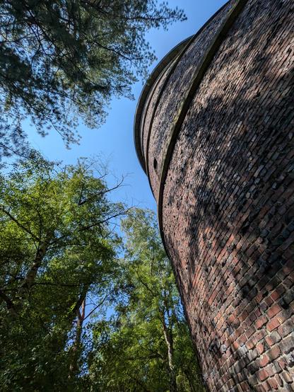
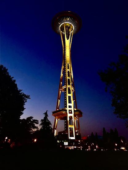
People will soon be able to bike the most direct route between downtown and the Space Needle entirely within a protected bike lane. People using the 4th Ave bike lanes today are unceremoniously spit out on to a wide, four-lane roadway with only sharrows painted on the ground. This is bad for all users, but it’s especially jarring for people unfamiliar with biking in the city who are just trying to get from the center of downtown to the city’s most iconic and visible landmark. The lane has ended abruptly at Vine since 2021 when the 4th Ave bike lane was finally constructed after years of delays.

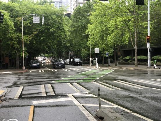
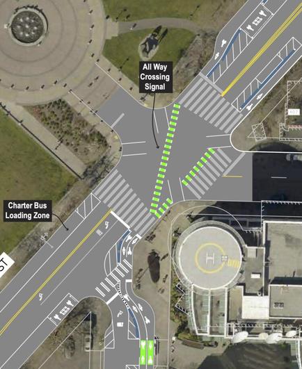
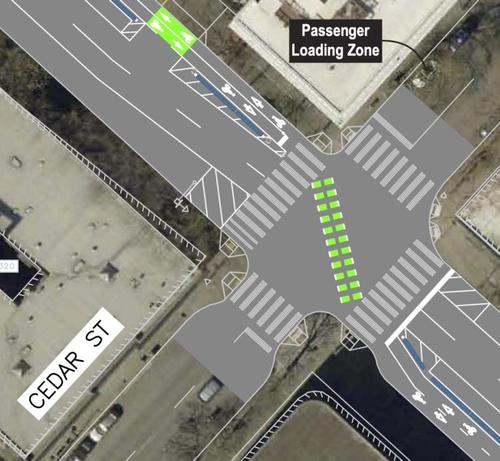
The existing bike lane will extend one more block from Vine to Cedar. At Cedar, a new diagonal bike lane crossing will shift the two-way bikeway from the southwest side of 4th Ave where it is through downtown over to the northeast side. We were critical of this diagonal shift in our previous post, but the project team pointed to a few advantages they say make it work better.

One advantage is that most people driving on 4th Ave make a left turn onto Denny Way. There is also a double-lane left turn at that intersection and no crosswalk on the east side. Moving the bikeway so it can cross Denny on the east side will make this intersection much easier and give the bike lane a longer green light since it can be green during the left turn phase. No right turns will be allowed from 4th onto Denny.

One interesting consideration here, though, is that Mayor Katie Wilson has promised bus lanes on Denny Way where they are needed. So if the section of Denny between Broad and 4th got a westbound bus lane, then there would no longer need to be two left turn lanes from 4th to Denny, which would also make it much easier to add back that missing crosswalk and perhaps even move the bike lane to the west side of the street some day. Complete streets, when done right, can trigger a whole chain reaction of safety improvements like these. I hope the Denny Way team and the 4th Ave bikeway team are putting their heads together on how they can link up and support each other’s projects.

Another advantage of moving the bikeway to the east side of the street, however, is that north of Denny the bikeway would not cross in front of the 7-11 or parking lot driveways.

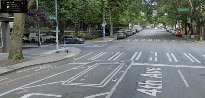
At Broad Street, the bikeway will split into two one-way bike lanes on either side of Broad. Most bike movements would happen during a new all-way walk and bike phase at this intersection in front of the Space Needle driveway.

Broad itself will be reconfigured to expand the amount of drop-off, charter bus, and bike and scooter parking. There will be one general traffic lane in each direction as well as some turn lanes, itself a big win since this street has maintained the design of a highway connector street, a role it has not played since 2014. However, we argued that the city should go even further by making the road one-way and dedicating about half of it to biking, Seattle Center access and maybe even some public art.

The problem is that it is currently designated as the hazardous freight route for trucks carrying cargo that is not allowed in the SR-99 tunnel, under the convention center downtown or on central downtown streets. Instead they must travel on the surface roadway along the waterfront, then travel up Broad to 5th, then to Mercer, then back to I-5. Very few trucks make this movement, but they do need an option. The city can change the hazardous cargo route, but that is likely a whole other project with its own challenges. Surely we can think of a better place than in front of our most popular tourist attraction, but hazardous cargo is also the kind of thing that nobody really wants near them. In the end, it was not something within the scope of this project.

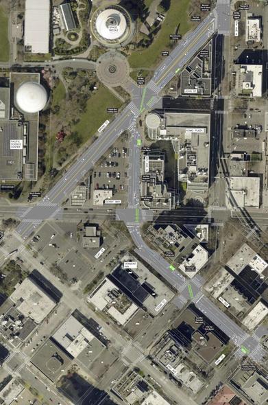
The need to preserve the street for these trucks means that they could not use the monorail pillars to demarcate new car-free space along the edge of Seattle Center, as was Seattle Bike Blog’s suggestion. The team modeled it out and found that large trucks would have difficulty making the turn around the monorail pillar, and a hazmat truck collision with a monorail pillar would be a pretty bad thing to happen. Now, I’m sure it could be done if there were also design changes on 5th Ave N, but again that gets out of the scope of this project.

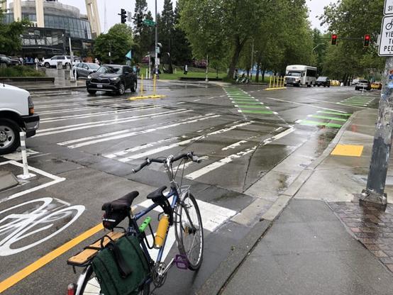
Finally, the project will add an all-crosswalk phase at the 5th/Broad/Thomas intersection, which will allow people on bikes to connect between the new lanes on Broad to the bikeway on Thomas Street.

The project makes a couple needed connections while leaving a couple big ones hanging. There will be no connection to the existing 5th Ave bikeway north of Memorial Stadium, and there will be no bike lanes on Broad Street between 4th Ave and the new waterfront bikeway. There is a block of protected bikeway on the north side of Broad between 1st and 2nd Avenues, but nothing between 1st and the waterfront or between 2nd and 4th. Completing the Broad Street bike connection was, you guessed it, outside the scope of this project.

Seattle bike network is coming together in patches. Sometimes we get big patches. This one is a small patch. It is frustrating to leave such large gaps open, but it is still a significant improvement over the current state.

#SEAbikes #Seattle

Kids playing in the International Fountain at the Seattle Center.

📷 Olympus C2500L / April 2004

On Flickr: https://www.flickr.com/photos/djwudi/2923196/

#photography #olympus #c2500l #seattle #SeattleCenter #InternationalFountain

Watch: Bob Svercl visualizes better options for the 4th Ave to Space Needle bike lane

https://www.youtube.com/watch?v=chNjzjeydDU

Bob Svercl recently created a video with fancy graphics showing a couple options for the city’s planned bike lane to connect the 4th Ave bike lane to Seattle Center near the Space Needle. Bob shows the city’s early design concept, a version of the one I suggested previously on Seattle Bike Blog, and a third idea of his own that bypasses Broad Street entirely.

It’s a great video that helps visualize things better than the big block of text I wrote. I still like my idea the best in large part because I really like the potential for a better Broad Street beyond just the bike connection. But Bob’s concept of staying on the east side of 5th Ave could be the easiest and most direct bike route connecting to both Thomas and Mercer Streets. There is more space on the east side of 5th, and though it sure would be nice to connect to the stub bike lane on the west side of the street south of Mercer, it could very well be easier to complete the connection on the east side instead.

I like Bob’s idea better than the city’s early design because it is a quality bike connection that doesn’t have an awkward diagonal crossing and doesn’t muck up any future projects on Broad Street. If they aren’t going to do Broad the right way now, then let’s wait to do it justice later. It could be such a cool space someday, and a remake could be part of a future Broad Street bike connection to the waterfront.

Bob’s graphics did a pretty good job of capturing what I wrote, but I guess I want to clarify that I’m imagining more dramatic changes to Broad Street than is pictured. The street should preserve access to the pickup zones and parking lots while utilizing the rest of the space for the bike lane, enhanced crosswalks, charter bus and car pickup zones, and maybe even some public art in the future (perhaps a gateway to the space needle of some sort?). Make all or most of Broad from 5th to Denny one lane one-way southwestbound, which would allow for a much less complicated intersection at 4th, Broad and John. John would become the preferred way to and from the Space Needle loop, assuming we still want to keep that open to cars (I’m guessing the Space Needle folks do in fact want this). Again, Broad Street is no longer a freeway access road, so its design needs to change. The current design isn’t doing anybody any favors. My take is that its primary role today is as a Seattle Center gateway, and so that’s how we should be designing it.

#SEAbikes #Seattle

I just want to point out that the Seattle Center at night can be pretty creepy #seattle #seattlecenter #creepy #horror #atmosphere #atmos #photography #photo

Took my meshcore radio up the Volunteer Park water tower today.

I'm pretty floored by how well it worked!

This one node was able to bridge connections from Capital Hill, Seattle Center, Shoreline, the 520 bridge and many points in between.

I was only up there an hour but was able to chat with people all over the city.

#Seattle #MeshCore #VolunteerPark #WaterTower #LoRa #radio #CapitalHill #SeattleCenter #Shoreline #rt520 #Greenlake #Ballard

Seattle Space Needle
I was out and about with the kids and thought,Why not?
#Seattle #SpaceNeedle #SeattleCenter