The thread about a Leith communion token and how it can help us understand just why the Victorians built so many churches

This thread was originally written and published in October 2021.

Today’s Auction House Artefact is very topical given it’s the 31st October. No, it’s nothing to do with Halowe’en, sorry. It’s a Communion Token and of course today is also Reformation Day.

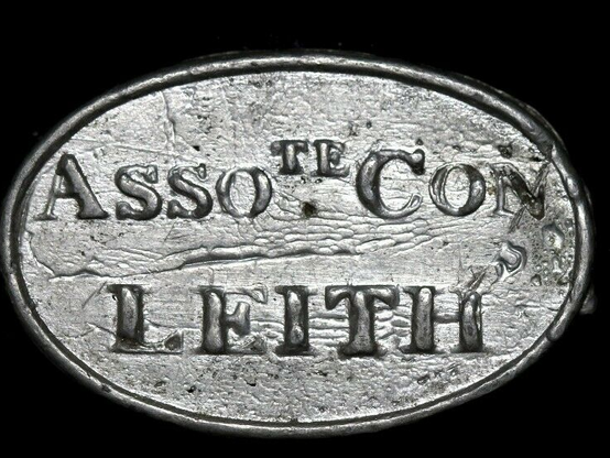
Front (MR. J. S. 1825) and Rear (ASSOte. CON LEITH) of a Leith Communion token. Drag the slider to compare

It’s just a small, roughly cast pewter token. But what is it, what do the abbreviations mean and what does it have to do with my usual subjects of interest? Well, obviously it’s marked LEITH, so that’s a start and the method by which it came to my attention. Beginning with what communion tokens are (and I’m no expert here, so do wade in if I’m wrong), they are peculiar to Reformed churches and the concept dates all the way back to John Calvin in the 16th Century. They were first issued in the Netherlands, but really became a thing of the Scottish reformed Kirk and all its various offshoots. There are at least 5,000 known different Communion tokens specific to Scottish churches alone. A communion token was a method to identify members of a congregation who practised “closed communion“; i.e. only known members of the congregation can participate. No token? No communion. Tokens were issued to those who had taken the necessary catechism (religious instruction).

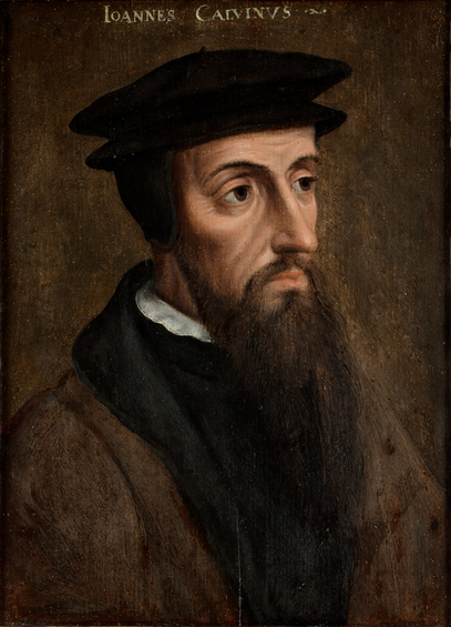
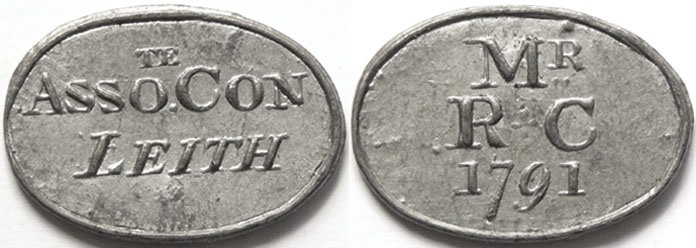
John Calvin, a key influence on John Knox, the architect of the Scottish Reformation

Back to our token. What do the abbreviations mean? On the front it says, MR J. S. stands for “Minister, John Sharp”. The date of 1825 was not the date of issue of the token but most likely the date that the Rev. Sharp took over the congregation. On the rear, it stands for Associate Congregation, Leith, the name and denomination of the church. Below is an earlier issue, for Sharp’s predecessor, Robert Culbertson, who served from 1791 until his untimely death in 1823.

1791 Leith Associate Congregation communion token

So what is an Associate Congregation and why is it interesting I hear you say? Well to answer that you heave to delve into the amusingly elaborate timeline of the various reformed churches in Scotland since the (Scottish) reformation .

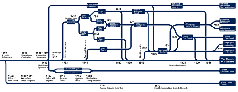
The timeline of the evolution of churches in Scotland from 1560

If you go way back to 1733, some congregations began to secede from the established Church of Scotland (“the Kirk“). The Seceders left for various long-standing and unresolved reasons, particularly the threat of the patronage of Lairds in preventing a congregation choosing its own minister, which has been a key issue in Scottish Presbyterian churches since the Reformation. The Seceders were led by Ebenezer Erskine, minister in Stirling, formed their own church court, known as the Associate Presbytery.

Ebenezer Erskine, 1680-1754. CC-BY-NC National Galleries Scotland

They were summoned to answer by the Kirk in 1739 but refused as they did not recognise its authority over them, so were deposed. This had two effects. Firstly, the seceder congregations were ejected from their churches so had to find new homes. It also rallied parishioners to their cause and the new churches ranks were swelled. At this time I’m not sure what presence, if any, they had in Leith. This split was around a religious clause in the oath that burgesses had to take. The burgesses were the “freemen” of the burgh, an important position in Scottish society at the time. The “Burgher Oath” had to be taken in the royal burghs of Edinburgh, Glasgow and Perth. The hardliners refused to take the oath as they felt it would mean that they recognised the authority of The Kirk. The result was that the General Associate Synod split off of the Associate Synod, these two sects are better known as the Antiburghers and Burghers. So this is why you get those odd-sounding things on old maps of Edinburgh called Burger Meeting and Antiburger Meeting houses.

Seceder Meeting House, 1765Antiburgher Meeting House, 1784Burger Meeting House, 1784Different seceder meeting houses in the 1765 and 1784 Edinburgh Town Plans. Reproduced with the permission of the National Library of Scotland

Maps of this time refer to “meeting houses” or “chapels”, likely they were not officially recognised by the mapmakers as churches in their own right, this title being reserved for the parish kirks alone. From the maps we can see a Seceders’ church on Bristo Street in 1765 and by 1784 it is the Burgher Meeting house and the Antiburghers have their own separate house.

If you’re still following, give yourself a pat on the back, because it’s about to get even more confusing…

But before then, let’s go back to Leith. The first Antiburgher Church was formed in the Kirkgate in Leith in 1766 following a stushie within the South Leith Kirk congregation over the appointment of the new minister William Aitken. They met in a meeting house on Cables Wynd, ordaining a minister John Proudfoot in 1772. Funds were raised to erect a purpose built church on the Kirkgate just over the wall from South Leith Kirk, which was completed in 1775.

The Antiburgher Meeting House off the Kirkgate in Leith, 1804 Town Plan by Ainslie. Reproduced with the permission of the National Library of Scotland

In 1785, the Rev. Proudfoot was suspended by the Antiburgher synod and deposed. This caused a split within his congregation. Some members returned to South Leith Kirk, but most stayed with Proudfoot as a “free” Antiburgher church. Proudfoot died in 1787 and his Antiburgher congregation petitioned the Burghers to join. This was granted and so once again there was a split, and the Antiburghers left to do their own thing, leaving the Burghers in the Kirkgate. The Antiburghers who left the Kirkgate petitioned the Antiburgher church, were welcomed back in and a new congregation was established in the old Glasite Meeting House (let’s not go there!) off of St. Andrew’s Street, becoming the St. Andrew’s Street Antiburghers.

St. Andrew Street Chapel (Congregational), from 1849 OS Town Plan. Reproduced with the permission of the National Library of Scotland

Anyway, in 1791, they appointed Robert Culbertson as their minister who was quite the scholar and patron of many things. He was notable enough to be subject to a caricature by John Kay. His church was an Associated Congregation, i.e. a member of the General Associated Synod, hence the stamp on the communion tokens. In 1798 however yet another split happened resulting in the Antiburghers splitting into Auld Lichts and the New Lichts (old and new lights). The same happened to the Burghers eight years later.

John Kay’s caricature of Rev. Robert Culbertson

Culbertson was a New Licht Antiburgher, more theologically liberal than the Auld Lichts who held more strictly to Calvin and the Covenanting tradition. He was a popular and influential minister and donated heavily to the Edinburgh Bible Society and the Leith Public Library. Soon, the New Lichts of the Burgher and Antiburgher churches realised what united them was greater than what divided them, and a union took place. Culbertson was on the negotiation committee and “greatly rejoiced” on its success. The result was the United Secession Church of 1820 . Culbertson died an untimely death in 1823, falling ill during a meeting of the presbytery of the new church. He did not live to see his congregations grand new premises, which was not completed until 1826.

The Auld and New Lichts split off of the Anti-Burgher and Burghers

That church was built on land acquired from the city next to the High School of Leith, built by John and James Rutherford in the classical style. The St. Andrew’s Street congregation named the new street St. Andrew’s Place after their church. The building is now the B-listed Edinburgh Hindu Mandir & Cultural Centre.

St. Andrews Place United Secession Church. © Edinburgh Hindu Mandir & Cultural Centre

In 1825, Culbertson’s vacant pulpit was filled by the Rev. John Smart (1801-1871), who initially lived opposite on Morton Street. Smart was minister until 1845. In 1847 the United Secession Church merged with another split off of the Kirk – the Relief Church*1 of 1761 – to form the United Presbyterian Church, which is what all those “U. P. Churches” are on Victorian maps of Scottish towns.

John Smart, by Thomas Dick. CC-by-NC National Galleries Scotland
  • The Presbytery of Relief, to give it its formal name, was founded by Thomas Gillespie who had been deposed by the General Assembly of the Kirk for refusing to induct a parish minister against the wishes of the congregation (that old issue again!). In this case, “relief” meant relief from the patronage of Lairds to choose the parish minister. They were a liberal church, patronised by independents and Episcopalians. ↩︎
  • So in 1849, the Antiburgher church is now the St. Andrew’s United Presbyterian Church, (“seats for 1400” – the established South Leith Kirk only had 1200). The original hall was half that size and kept on as a meeting hall.

    St. Andrew’s United Presbyterian Church. 1849 OS Town Plan. Reproduced with the permission of the National Library of Scotland

    Remarkably, a photo exists of the original meeting house off St. Andrew’s Street. It was actually on Storrie’s Alley. It is seen here in the early 1960s when it was used by the YMCA, before being swept away. The French-style roofline of Yardheads School is the giveaway of the location, peeping out to the left of the church gable. The hall stood infront of the remaining old buildings, a former bonded warehouse..

    The original St. Andrew’s Street Antiburgher Church, overlaid on the modern street

    In the late 1880s/early 1890s, the St. Andrew’s Place congregation opened a mission hall on Jane Street in Leith, a charming little building which is still there and is some sort of hotel/hostel thing.

    St. Andrew’s Place U. P. Church Mission Hall

    Back to our diagram. In 1900, the U.P. Church joined with the Free Church (of the ominous sounding “Disruption of 1843“) to form the United Free Church (or U.F. Church on maps). By this time, the Kirkgate Congregation was also in this fold.

    The formation of the United Free Church in 1900

    The Kirkgate congregation had by this time moved to a new and altogether grander premises on Henderson Street (see pictures below). While this fine and unusual looking church has unfortunately been demolished, that carving above the door and the cross survive as ornamentation on the otherwise modern and austere South Leith church halls.

    Kirkgate U.P. ChurchThe frieze above the doorAnd today, the South Leith parish church hallsThe Kirkgate U.P. Church on Henderson Street,

    In another picture from Edinburgh City Libraries, here we see the entrance to Storrie’s Alley off of St. Andrew’s Street. In amongst all the Victoriana we see a lantern pointing the way to the St. Andrew’s Hall.

    Lantern pointing to St. Andrew’s Hall © Edinburgh City Libraries

    The St. Andrews associate congregation completed its 360 degree journey in 1929 when it was one of the United Free Church congregations that merged back into The Kirk, becoming Leith St. Andrews. In 1973 it joined with the Claremont Church of Scotland at the foot of Easter/ Lochend Roads and relocated to the latter premises, which took up the name of St. Andrew. Around 2003, this combined congregation was joined by another from the district; that of Junction Road and St. Thomas’, as two more old churches in Leith became surplus to modern requirements.

    St. Andrew’s Church of Scotland at the foot of Easter Road. CC-BY-SA Alan Murray-Rust

    When the Kirkgate Associate Congregation moved to its new home on Henderson Street in 1886, the old church became the Princess Theatre and music hall, which burned down 2 years later (as such places often did). The New Princess, later the Gaiety, rose from the ashes. The Kirkgate Congregation followed the route of St. Andrew’s Place, and returned to the Church of Scotland in 1929. It merged with the South Leith congregation in 1973 and vacated the Kirkgate Church, which was demolished and replaced by the South Leith Church Halls.

    Anyway, the moral of the story is that even if you are not religiously inclined it pays to get your head around at least a bit of it as it really helps understand maps and buildings and local history. Especially the question “why did the Victorians build so many dang churches?”.

    Note to readers: unfortunately in April 2026, a third-party plug-in more than exceeded its authority and broke many of the image links on this site. No images were lost but I will have to restore them page-by-page, which may take some time. In the meantime please bear with me while I go about rectifying this issue.

    If you have found this site useful, informative or amusing then you can help contribute towards its running costs by supporting me on ko-fi. This includes my commitment to keeping it 100% advert and AI free for all time coming, and in helping to find further unusual stories to bring you by acquiring books and paying for research.
    Or please do just share this post on social media or amongst friends and like-minded people, sites like this thrive on being shared.

    Explore Threadinburgh by map:

    Travelers' Map is loading...
    If you see this after your page is loaded completely, leafletJS files are missing.

    These threads © 2017-2026, Andy Arthur.

    NO AI TRAINING: Any use of the contents of this website to “train” generative artificial intelligence (AI) technologies to generate text is expressly prohibited. The author reserves all rights to license uses of this work for generative AI training and development of machine learning language models.

    #Lochend #Logan #Restalrig #StMargaret

    Around Craigentinny: the thread about Scots, English, Gaelic, Dutch, Cornish and Irish origins of suburban streetnames

    I recently wrote a thread about the meanings of the street names on the old Easter Duddingston estate, and how nearly all are linked to the Abercorn family. So now it is the time to boldly stray north of Moira Terrace and the Portobello Road to see what lies on the other side and where its street names come from (spoiler: it’s Craigentinny, and once again they come almost entirely from one family!)

    By Craigentinny I mean the area defined by the old estate on that name, which was itself the eastern portion of the older Barony of Restalrig. The origins of Craigentinny are somewhat obscure but the most frequently told version says it was land acquired by one James Nisbet1 from the Logans of Restalrig in 1604. Here he built a tower house (or improved an existing one) which for reasons known to himself Christened Craigentinny. The roots of that name are Gaelic but the precise meaning is lost to time, the usual explanation is Creag an t’Sionnaich or Fox Rock. You can read a bit more on the origins and history of the house over at Stravaiging Around Scotland.

    Craigentinny House, much modified in a Scottish Baronial Revival style in Victorian times, c. 1880. © Edinburgh City Libraries

    After 160 years in hands of various Nisbets the house and estate was bought in 1762 by William Miller (1722-1799), a wealthy Quaker seed merchant from the Canongate who was known locally as “King of the Quakers“. He had a single surviving son late in life by his third wife, his heir William Henry Miller. William Henry inherited on his father’s death in 1799.

  • James Nisbet (1557-1621), son of Henry Nisbet of Dean, established the Nisbet of Craigentinny line.
    He was followed by his son
    Sir Henry Nisbet (1584-1667), who was followed by his 4th son Sir Patrick Nisbet (1623-1682). Patrick exchanged titles with his cousin – Sir Alexander Nisbet of Dean – in 1672 with the latter becoming Sir Alexander Nisbet of Craigentinny (1630-1682). He was succeeded by his second son, Capt. Alexander Nisbet (1688-1735), his eldest son Sir William having succeeded instead to the Nisbet of Dirleton line. The former did not have a male heir, so Craigentinny passed via Alexander’s sister – Christian Nisbet (1692-1738) – to his nephew John Scott (1729-1764), the oldest grandson of Sir Alexander Nisbet. John took the double-barrelled surname Scott-Nisbet to inherit the title and sold Craigentinny to William Miller the Quaker in 1762, whose father already possessed Fillyside Farm on the estate. ↩︎
  • The image below shows the 1847 estate boundary, which was altered slightly when the North British Railway came through this district to make sure there were no isolated parts of Craigentinny or Duddingston on the respectively wrong side of the tracks.

    Outline of the Craigentinny estate (and surrounding principal estates) projected onto a modern 2023 aerial photo.

    William Henry Miller became MP for Newcastle-Under-Lyme in 1830, spending most of his time on an estate he purchased in England, where he set about amassing one of the most important book collections of its time. It is he who is buried far beneath the magnificent Craigentinny Marbles mausoleum on his Edinburgh estate, which you will find sticking out like a sore thumb amongst the 1930s bungalows of Craigentinny Crescent.

    The Craigentinny Marbles, CC-by-SA 4.0 Blackpuddinonabike

    When William Henry Miller died in 1848 he was unmarried and without heir (there are baseless antiquarian rumours that he may have been variously a Roman Catholic, adopted, a woman or even intersex, but those are beside the point here). His will disbarred his closest relations from inheriting and the estate was instead bequeathed to his “nieces” or “cousins”, Sarah and Ellen Marsh, who continued to lived at Britwell and Craigentinny. There is an unsolved mystery as to the precise relation of the Marsh sisters to Miller; they certainly weren’t direct relations and may instead have been close companions of his Mother. The sisters had to defend the will in court – there were years of legal wrangling and competing claims by other Miller relative – before they could inherit. When they did, the Lord Lyon granted them the use of the Miller title and arms.

    On the death of the surviving sister, Ellen, the estate was inherited by a distant cousin of the Millers, Samuel Christy. He was an English hatter from the well known firm Christy & Co. and also a Quaker. As part of his inheritance Samuel formally changed his surname to Christy-Miller. This was was soon changed to the Scottish form of Christie-Miller (the Christys were, after all, descendants of an Aberdeen Christie).

    Cover of “One Hundred and Seventy Five Years of the House of Christy” by Arthur Sadler FRSA

    Note that some sources will tell you that William Henry Miller was also known as Christiemiller; that’s patently not true. He died in 1848, and Samuel Christy didn’t fully inherit and change his name until fourteen years after his death in 1862! To confuse matters further, Samuel also had an unrelated uncle called William Miller Christy! It was this establishment of the new family name of Christie-Miller that gives us our first street name on this local history tour – Christiemiller Avenue (and later Place and Grove), which was developed from 1931 onwards.

    Christiemiller Avenue, Place and Grove highlighted. 1944-45 OS Town Plan of Edinburgh. Reproduced with the permission of the National Library of Scotland

    Samuel Christie-Miller was predeceased by his only son so Craigentinny passed to his nephew Wakefield Christy in 1889, who thus became Wakefield Christie-Miller and gives his name to Wakefield Avenue. (Wakefield being his mother’s maiden name.)

    Wakefield Avenue highlighted. 1944-45 OS Town Plan of Edinburgh. Reproduced with the permission of the National Library of Scotland

    At the other end of the bungalow belt from Wakefield Avenue is Britwell Crescent. Britwell is a medieval Cambridgeshire name (from Bright Well) and it was where William Henry Miller had bought the estate and house of Britwell Place as his southern residence on becoming an MP in 1830. It was here where Miller built a library for his book collection in a purpose-built, fireproof wing. This property passed via the Marsh sisters to the Christie-Millers and is now known as Grenville Court.

    Britwell Place, now Grenville Court, site of William Henry Miller’s library

    Moving east through Craigentinny again, we come to Sydney Terrace, Place and Park. These are named for Sydney Richardson Christie-Miller, who inherited the estate in 1898 on the death of his father Wakefield.

    Sydney Terrace, Place and Park highlighted. 1944-45 OS Town Plan of Edinburgh. Reproduced with the permission of the National Library of Scotland

    Bordering these last streets are Vandeleur Avenue, Grove and Place, which are named for Evelyn Vandeleur, wife of Sydney. She was of the Anglo-Irish gentry but Vandeleur is an old Dutch and Flemish name – Van de Laer or Vanderloo means one who lives in a grove. There have been Vandeleurs in Kilrush, Co. Clare, since Oliver Cromwell’s time. That Dutch / Flemish connection is highly unusual in Edinburgh place names (it may be unique!) and I think we can say the same of the next street along, Kekewich Avenue, which is Cornish! The connection here is that the Christie-Miller family lawyer when this street was formed was one C. Granville Kekewich, esq.

    General Sir John Ormsby Vandeleur, great Grandfather of Evelyn Vandeleur. By William Salter, pre-1849. National Portrait Gallery, London, NPG3762.

    Up from Kekewich is the solidly Scottish Bryce Avenue and Grove. Andrew Bryce of Southside Bank Farm was the estate factor for the Christie-Millers. His Victorian farmhouse still exists, hiding in plain site between Vandeleur and Kekewich Avenues off the Portobello Road.

    Southside Bank Farmhouse, also known as Craigentinny Mains

    Off of Bryce is Goff Avenue. Goff is from the Anglo-Irish wing of the Christie-Miller family again, from the English Goffe or Gough – Wakefield Christie-Miller’s youngest son was Edward Goff Christie-Miller. The Goff branch descended from Major General William Goffe, or William the Regicide, a parliamentarian army officer and Cromwell loyalist who had put his seal and signature on the death warrant of King Charles I. This connection again may be unique in Edinburgh street names.

    William Goffe’s signature and seal on the death warrant of King Charles I. Parliamentary Archives, HL/PO/JO/10/1/297A

    In the northern sector of the Craigentinny Bungalowopolis we find Nantwich Drive and Stapeley Avenue. Both are Cheshire placenames: Stapheley House in Nantwich was bought by the Christie-Millers in 1910 and Geoffrey Christie-Miller settled there. It was turned over to a war hospital in 1914-18. Geoffrey, another of Wakefield’s sons, was a decorated war hero in that conflict with the Oxfordshire & Buckinghamshire Light Infantry. He and his wife honeymooned at Craigentinny House in 1908 and he took an active interest in the running of the Craigentinny estate and family hat business

    Geoffrey Christie-Miller, 1881-1969 Buckinghamshire County Archives Roll of Honour.

    The last 2 streets with Christie-Miller connections lie to the south of Moira Terrace: Parker Road / Avenue / Terrace and Farrer Terrace and Grove. Christopher Parker and Helen Farrer were parents-in-law to Sydney Christie-Miller’s brother Charles and were godparents to a number of his children.

    Parker and Farrer street names highlighted. 1944-45 OS Town Plan of Edinburgh. Reproduced with the permission of the National Library of Scotland

    All of these streets are part of the bungalow belt sprawl (although there are some earlier Edwardian villa flats) dating from around 1934 and on the lands of the Southside Bank and Fillyside Bank farms. But the estate had a third farm in addition to these, that of Wheatfield. The Georgian farmhouse of Wheatfield is another of those “oh, I didn’t realise I’d been looking at it the whole time” buildings, it’s just down from the Marbles, set back far enough from Moira Terrace behind a tall, gateless wall to be quite unobtrusive and it does not lend its name to any streets.

    Wheatfield farmhouse off of Moira Terrace.

    Much of the lands of the farm of Wheatfield were purchased by the Corporation of Edinburgh in 1932, along with Craigentinny House and its gardens, the old Piershill Barracks and Piersfield portion of the Parson’s Green Estate for council housing and a new school. These streets were given Loganlea and Loaning names. The former comes from Loganes Ley, a field elsewhere on the old Logan Restalrig barony where the wappenschaw took place: the muster and demonstration of men and their weaponry who were obliged to perform military service for the town or laird. The latter street names come from loaning, a generic and common old Scots placename; a loan being a lane, and a loaning implying a public right of way along it. This refers to the old route across the Craigentinny Meadows, which began at the gates of Craigentinny House.

    Loganlea council housing

    The Craigetinny Loaning lead across those “Irrigated Meadows” to the farm of Fillyside Bank. Most of the land of this farm was not built upon for housing, it instead was developed to form the Craigentinny Golf Course, with portions containing a Corporation refuse depot and sewage pumping station and the Meadows Yard railway sidings.

    Kirkwood’s 1817 Town Plan, with Craigentinny House and Fillyside Bank farm highlighted. The loaning runs between the two. Reproduced with the permission of the National Library of Scotland

    But there was some bungalow building on the farmland, inclduing the streets of Fillyside Road, Terrace and Avenue. Fillysydebank, also known as Greenbank, is first mentioned in 1553. It was also at times the East Mains and North Mains of Restalrig. Filly- comes from the Scots Falu-, a topographical descriptor for “yellowish” land. There is yet another old house hiding in plain site nearby, off Seafield Street, that takes the name Fillyside. However it took this purely as a loan when it was built in 1810 and was never on the Nisbet / Miller / Christie-Miller Craigentinny estate land, but just over the boundary from it.

    Fillyside House, as seen from Seafield Street

    Note to readers: unfortunately in April 2026, a third-party plug-in more than exceeded its authority and broke many of the image links on this site. No images were lost but I will have to restore them page-by-page, which may take some time. In the meantime please bear with me while I go about rectifying this issue.

    If you have found this site useful, informative or amusing then you can help contribute towards its running costs by supporting me on ko-fi. This includes my commitment to keeping it 100% advert and AI free for all time coming, and in helping to find further unusual stories to bring you by acquiring books and paying for research.
    Or please do just share this post on social media or amongst friends and like-minded people, sites like this thrive on being shared.

    Explore Threadinburgh by map:

    Travelers' Map is loading...
    If you see this after your page is loaded completely, leafletJS files are missing.

    These threads © 2017-2026, Andy Arthur.

    NO AI TRAINING: Any use of the contents of this website to “train” generative artificial intelligence (AI) technologies to generate text is expressly prohibited. The author reserves all rights to license uses of this work for generative AI training and development of machine learning language models.

    #Lochend #Logan #Restalrig #StMargaret
    #HappyHalloween #Halloween #October31 #NotArt #happyhalloween2025 #Halloween2025
    If something bad happens on #October3st, it could be due to either a coincidence of unfavorable events or superstition. There's a belief that on this day, one should avoid lending money, cutting down trees, shouting loudly, or leaving the house at night, to avoid bringing misfortune.

    Happy birthday to #RobSchneider
    #Happybirthday to #justinchatwin

    Am so happy to celebrate with you guys today #bahdlexbirthday #bahdlex #Congratulations 🥂🍾🎉🎀 #HBD #HappyBirthdayWishes #celebrities
    🍾🍿🥧🍬🥂 #October2025 #Oct31 #october31 #october #birthdayboy

    Happy birthday #Piperperabo 🥂
    Happy birthday #DermotMulroney
    Happy #birthday #JohnCandy 🎉

    Am so happy to celebrate with you #Congratulations 🍾🎉🎀 #HBD #HappyBirthdayWishes #celebrities 🍬🥂🍾#bahdlex #Bahdlexbirthday #October2025 #Oct31 #october31 #october #birthdayboy