Buenas madrugadas ☕️😊☕️
Hoy a las 19:00 CDMX hablaré un poco de lo que he hecho a favor del conocimiento libre.

Buenas madrugadas ☕️😊☕️
Hoy a las 19:00 CDMX hablaré un poco de lo que he hecho a favor del conocimiento libre.
For some upcoming outdoor adventures I'm currently looking for a map solution with some special requirements that seem rather rare or not existent at all:
– Download (complete) OSM data for small area, let's say 4 to 9 km². I understand that's difficult because of how OSM data downloads are bundled, but I don't mind downloading the entire region, as long as the data is "complete" (not stripped of information that some provider deemed unimportant - CoMaps map downloads for example apparently don't include structures outside of cities).
– Download satellite imagery tiles for the given area for offline use. That's probably difficult cause providers want money for their satellite stuff, however OSMAnd for example can display Microsoft Earth imagery as over/underlay for free, so I guess those should be cacheable somehow. As mentioned above it's be for a rather small predefined area.
– Display both OSM map and satellite imagery at the same time like OSMAnd does with the over/underlay, with configurable opacity for the layers.
– This one's tricky: possiblity to (freehand) draw on the map (and obviously having my sketches pan/zoom along with the map when moving around).
– Put markers on the map with notes and have the notes displayed on the map itself, not just the marker that you gotta tap to have the note pop up.
OSMAnd comes pretty close, but doesn't download/cache satellite imagery for offline use, markers are a bit cumbersome for a quick note and it doesn't support drawing on the map.
I'm mostly looking for an Android app, however I'm not opposed to buying a dedicated GPS device if it does everything above. Right now the best solution I can think of is configuring an OSM map with all the desired information, print it out and just draw on the paper map, with the obvious downside that it doesn't show my position and also doesn't zoom well.
Any suggestions welcome!
Un muy buen trabajo se hizo hace poco más de un mes en la #Araucanía al catalogar y mapear todos los árboles urbanos y tocones en el polígono dedicado a un estudio en la ciudad de #Pitrufquen .
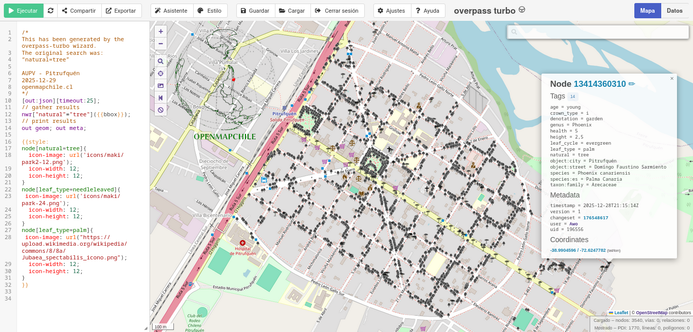
Recientemente la ciudad de Pitrufquén ubicada en la comuna homónima (Región de La Araucanía. Chile), a través de la Municipalidad solicito la elaboración de un catastro del arbolado urbano en el sector centro de la ciudad. Comprendiendo el polígono formado por las calles desde General Baquedano hasta Ohiggins en sentido Este-Oeste y desde Domingo Santa María hasta Caupolicán en el sentido Norte-Sur. La superficie del polígono a mapear es de 80 hectáreas, con urgencia de ejecución de diez...
Aufgeführt sind die Wertstoffinseln des ZAW sowie die Altkleider Container von verschiedenen Anbietern, ebenso der Wertstoffhof und die Kompostieranlage. **Wer Dinge nicht wegwerfen sondern reparieren oder weitergeben möchte findet auch die Reparatur-Cafes (Makerspaces) oder Sozialkaufhäuser.** Zusätzlich, aber ausgeblendet sind die Hundekotbeutelspender. [[https://www.awg.de/abfallentsorgung/wo-entsorgen | zur **ZAW** Website]] [[https://bbg-bayern.de/standorte/ | zur **BBG-Bayen Donau-Wald** Website]] [[https://de.wikipedia.org/wiki/Recycling | **Recycling** auf Wikipedia]] Fragen Probleme Änderungen: [email protected] alle Daten stammen aus [[https://www.openstreetmap.org/#map=13/48.82518/12.92919 | **OSM** opensteetmap]]
L'IGN Annonce la réinvention de la roue en souhaitant fabriquer un socle cartographique commun en dehors des communs déjà existants sur le sujet.
https://www.ign.fr/actualites/souverainete-numerique-leurope-se-dote-dun-socle-cartographique-commun
Cela fait plus de vingt ans que l' #Europe et le #monde alimentent déjà un socle cartographique commun avec une gouvernance ouverte et une richesse d'informations inégalée, ce socle est #OpenStreetMap. Ne perdons plus de temps à inventer des silos de communs qui existent et ont déjà fait les preuves de leurs avantages et d'une communauté qui s'étend bien au delà des frontières de l'Europe. Cette annonce est d'autant plus stupéfiante que l'#IGN porte le commun numérique #Panoramax.
Ne gaspillons pas d'avantage les fonds publics, réutilisons et contribuons toutes et tous à #OSM.
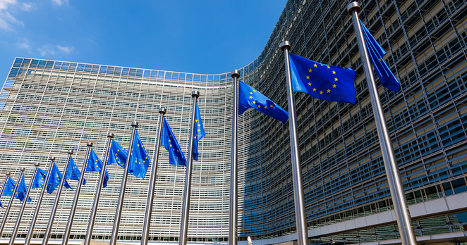
Plusieurs autorités nationales de cartographie, dont l’IGN, lancent la création d'un référentiel géospatial paneuropéen inédit destiné à soutenir les politiques publiques. Ce socle commun vise à harmoniser des données officielles de référence pour renforcer l’autonomie décisionnelle du continent.
Places named after Patrick (or Padraig) on the island.
Data from OpenStreetMaps, styling in QGIS.

Booked a hotel for SOTM.