#MappingChallenge (Day 72/100)
After publishing a tutorial on #mapwithai the other day, decided I might as well take it for a test spin.
Summary:
JOSM: 1
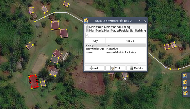
The first time I worked with #MapWithAI.
Tomorrow I might continue.
Das erste Mal, dass ich mit #MapWithAI gearbeitet habe.
Morgen mach ich vielleicht weiter.
#MappingChallenge (Day 72/100)
After publishing a tutorial on #mapwithai the other day, decided I might as well take it for a test spin.
Summary:
JOSM: 1
Just published a new tutorial on how to #mapwithai in #josm.

Looks like the AI-generated building footprints by #Microsoft has reached the #Philippines via #MapWithAI for #OpenStreetMap.
So far, they're looking quite good 👌
@ebel What is problem IMO is that if you -- as human being -- learn something, even from the proprietary code, you are free to use the knowledge in your FOSS project. The same works in the other direction.
I do remember there was similar discussion in #OpenStreetMap community regarding the #MapWithAI but I haven't found the link just now.
Do you use #JOSM ?
Have you tried out @[email protected] 's #MapWithAI plugin for validating @[email protected] ML road detections in your neighborhood?
https://gitlab.com/gokaart/JOSM_MapWithAI
---
RT @kaartgroup
"Happily, Kaart developer Taylor Smock t@[email protected], started building a Map With @[email protected], and then presented an early prototype to Facebook last September. …
https://twitter.com/kaartgroup/status/1240726935665143809
If you're planning to work on an area you know there are #MapwithAI detections, you just use the shortcut to validate the detections in #rapideditor instead of creating the roads from scratch. It might be quicker, or at least, helps improve the AI detections.
Take advantage of #MapwithAI 's #OpenStreetMap road detections for #RapiD editor from #JOSM.
Set a Utilsplugin shortcut for a custom URL you can activate with `shift+H` combo with this value "https://mapwith.ai/rapid#background=Maxar-FB&disable_features=points,buildings,landuse,boundaries&map=16.00/{#lat}/{#lon}"


Meanwhile, in the #OpenStreetMap in Asia Telegram channel, somebody from #Facebook reported that they're wrapping up their #mapwithai road mapping efforts in #Indonesia and are planning to start in #Malaysia soon.
Somebody from #Thailand inquired whether they have plans to do follow-up on cleaning data imports FB has done in the past.
