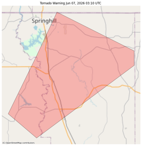
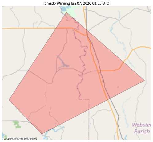
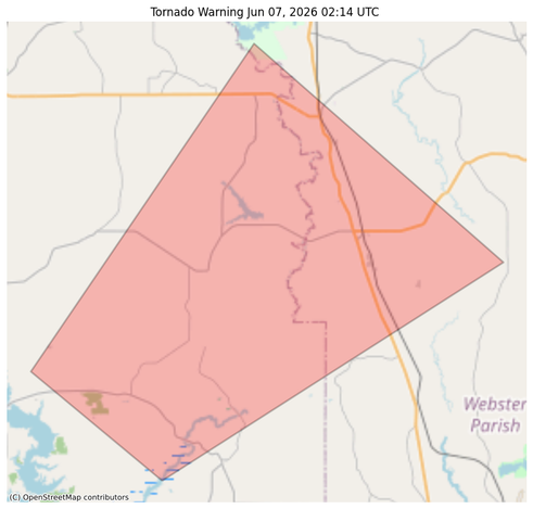
#EAS #WEA for CHLORINE LEAK - BLACKBURN RD.: Due to a chlorine leak located at 711 Blackburn Rd, Hammond, you are being advised to shelter in place until further notice. Turn off your AC. Keep all doors and windows closed. No evacuation is needed. As a precautionary measure, avoid this area. Source: LA_Tangipahoa_Parish #LAwx

** DO NOT RELY ON THIS FEED FOR LIFE SAFETY, SEEK OUT OFFICIAL SOURCES ***

#NWS #tornado Tornado Warning for Washington, LA #LAwx
At 849 PM CDT, a severe thunderstorm capable of producing a tornado
was located near Sun, or near Bogalusa, moving east at 15 mph.

HAZARD...TORNADO.

SOURCE...Radar indicated rotation.

IMPACT...Expect damage to mobile homes, roofs, and vehicles.

This tornadic thunderstorm will remain over mainly rural areas of
south central Washington Parish.

https://forecast.weather.gov/MapClick.php?lon=-89.957&lat=30.735

#NWS #tornado Tornado Warning for Washington, LA #LAwx
TORLIX

The National Weather Service in New Orleans has issued a

* Tornado Warning for...
South central Washington Parish in southeastern Louisiana...

* Until 915 PM CDT.

* At 836 PM CDT, a severe thunderstorm capable of producing a tornado
was located near Enon, or 9 miles southwest of Bogalusa, moving
northeast at 20 mph.

HAZARD...Tornado.

SOURCE...Radar indicated rotation.

IMPACT...Expect damage to mobile homes, roofs, and vehicles.

* This tornadic thunderstorm will remain over mainly rural areas of
south central Washington Parish.

https://forecast.weather.gov/MapClick.php?lon=-89.972&lat=30.729

#NWS #tornado Tornado Warning for Washington, LA #LAwx
TORLIX

The National Weather Service in New Orleans has issued a

* Tornado Warning for...
Southeastern Washington Parish in southeastern Louisiana...

* Until 915 PM CDT.

* At 826 PM CDT, a severe thunderstorm capable of producing a tornado
was located near Bogalusa, moving northeast at 10 mph.

HAZARD...Tornado.

SOURCE...Radar indicated rotation.

IMPACT...Expect damage to mobile homes, roofs, and vehicles.

* This dangerous storm will be near...
Bogalusa around 830 PM CDT.

https://forecast.weather.gov/MapClick.php?lon=-89.905&lat=30.788

#NWS #flood #nwsflashflood #FlashFloodWarning Flash Flood Warning for East Feliciana, LA; West Feliciana, LA #LAwx
FFWLIX

The National Weather Service in New Orleans has issued a

* Flash Flood Warning for...
Northwestern East Feliciana Parish in southeastern Louisiana...
Southeastern West Feliciana Parish in southeastern Louisiana...

* Until 830 PM CDT.

* At 526 PM CDT, Doppler radar indicated thunderstorms producing
heavy rain across the warned area. Between 3 and 5 inches of rain
have fallen. Additional rainfall amounts of 1 to 3 inches are
possible in the warned area. Flash flooding is ongoing or expected
to begin shortly.

HAZARD...Flash flooding caused by thunderstorms.

SOURCE...Radar.

IMPACT...Flash flooding of small creeks and streams, urban
areas, highways, streets and underpasses as well as
other poor drainage and low-lying areas.

* Some locations that will experience flash flooding include...
Jackson, St. Francisville, Wilson and Spillman.

5-7 inches of rain in Louisiana... that's a bit.

https://m.ai6yr.org/@flashflood_bot/116338302828328623

#LAwx #rain

Flash Flood Warning Bot (@[email protected])

Attached: 1 image #NWS #flood #nwsflashflood #FlashFloodWarning Flash Flood Warning for Livingston, LA; Tangipahoa, LA #LAwx At 850 PM CDT, The public reported flooding, caused by thunderstorms producing heavy rain across the warned area. Radar estimates between 5 and 7 inches of rain have fallen in the warned area. Flash flooding is already occurring in areas. HAZARD...Life threatening flash flooding. Thunderstorms producing flash flooding. SOURCE...Public reported. IMPACT...Life threatening flash flooding of creeks and streams, urban areas, highways, streets and underpasses. Some locations that will experience flash flooding include... Independence, Albany, Natalbany and Tickfaw. This includes the following Interstate... Interstate 55 in Louisiana between mile markers 36 and 42. Reports of many roads across Independence and Albany that are covered by water. Please do NOT cross water covered roadways!

AI6YR's Mastodon
NOW: A Tornado Watch has been issued for parts of Alabama, Louisiana and Mississippi until 4 AM CDT/5 AM EDT #alwx #lawx #mswx
NOW: A tornado watch has been issued for parts of Arkansas, Illinois, Indiana, Kentucky, Louisiana, Mississippi, Missouri and Tennessee until 12 AM EDT #arwx #ilwx #inwx #kywx #lawx #mswx #mowx #tnwx

@easwatch #EAS #WEA for #EastBatonRouge, #LAwx ; #East Feliciana, #LA; #Livingston, #LA; #StHelena, #LA; #Tangipahoa, #LA: National Weather Service: #TORNADO WARNING in this area until 9:00 PM CDT. Take shelter now in a basement or an interior room on the lowest floor of a sturdy building. If you are outdoors, in a mobile home, or in a vehicle, move to the closest substantial shelter and protect yourself from flying debris. Check media. Source: NWS New Orleans LA

** DO NOT RELY ON THIS FEED FOR LIFE

@easwatch #EAS #WEA for #PointeCoupee, #LAwx ; #WestFeliciana, #LA: National Weather Service: #TORNADO WARNING in this area until 8:15 PM CDT. Take shelter now in a basement or an interior room on the lowest floor of a sturdy building. If you are outdoors, in a mobile home, or in a vehicle, move to the closest substantial shelter and protect yourself from flying debris. Check media. Source: NWS New Orleans LA

** DO NOT RELY ON THIS FEED FOR LIFE SAFETY, SEEK OUT OFFICIAL SOURCES ***