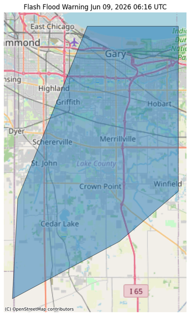
#NWS #flood #nwsflashflood #FlashFloodWarning Flash Flood Warning for Lake, IN #INwx
FFWLOT
The National Weather Service in Chicago has issued a
* Flash Flood Warning for...
Central Lake IN County in northwestern Indiana...
* Until 245 AM CDT.
* At 1143 PM CDT, Doppler radar and automated rain gauges indicated
thunderstorms producing heavy rain across the warned area. Between
1 and 2 inches of rain have fallen. Additional rainfall amounts of
1 to 2 inches are possible in the warned area, much of it over the
next hour. Flash flooding is ongoing or expected to begin shortly.
HAZARD...Flash flooding.
SOURCE...Radar and automated gauges.
IMPACT...Rapid-onset flooding of creeks, streams, drainage
ditches, streets, underpasses, low-lying areas, and
other poor drainage areas.
* Some locations that will experience flash flooding include...
Gary, Portage, Merrillville, Schererville, Hobart, Crown Point,
Highland, Cedar Lake, Lowell, Griffith, St. John, Lake Station,
Lakes of the Four Seasons, Winfield, New Chicago and Lake
Dalecarlia.