6/26
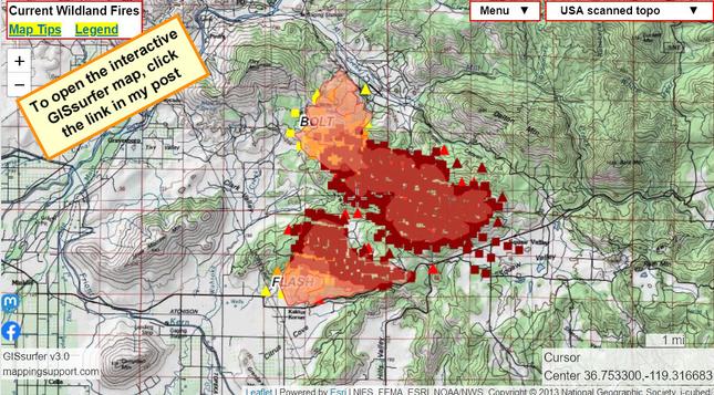
These fires are east of Fresno CA and were mapped around 2am this morning.
#FlashFire 2,180 acres
#BoltFire 4,556 acres

A bit to the east (you can drag the map) there is also a significant fire near Wilsonia and the visitor’s center for Kings Canyon National Park.

Map can show lots of #GIS layers. For help see 2 links upper left corner.
#CAfire #CAwx #FKULightningComplex #FlashComplex

Open GISsurfer map:
https://mappingsupport.com/p2/gissurfer.php?center=36.747803,-119.306384&zoom=12&basemap=USA_scanned_topo&overlay=State_boundary,MODIS_7_day,VIIRS_7_day,Wildland_fire_name,Perimeter_FIRIS&data=https://mappingsupport.com/p2/special_maps/disaster/USA_wildland_fire.txt

GISsurfer General Purpose Web Map and GIS Viewer | Surf GIS DATA

GISsurfer lets you surf a nearly endless amount of GIS data. Click a layer in the GIS server's table of contents and that data appears on the map.