LAX at 2:53 PM
🌡️ 70.0 F
🌫️ 55.9 F dew point
🌬️ West at 14 knots
🔭 10 miles visibility
☁️ Broken clouds at 25000 feet
⏱️ 1012.5 mb air pressure
LAX at 2:53 PM
🌡️ 70.0 F
🌫️ 55.9 F dew point
🌬️ West at 14 knots
🔭 10 miles visibility
☁️ Broken clouds at 25000 feet
⏱️ 1012.5 mb air pressure
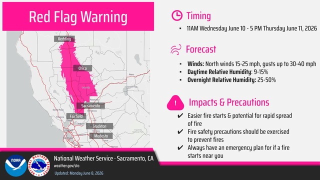
#EKA #CAwx 217
FXUS66 KEKA 082232
AFDEKA
AREA FORECAST DISCUSSION
National Weather Service Eureka CA
332 PM PDT Mon Jun 8 2026
.KEY MESSAGES...
- Rain will be coming to an end tonight with dry and slightly
below normal temperatures Tuesday.
- Temperatures are expected to warm up quickly Much warmer
weather next week into the weekend.
- Elevated fire weather conditions in Lake County with low
afternoon relative humidity and gusty winds Wednesday throu https://mesonet.agron.iastate.edu/p.php?pid=202606082232-KEKA-FXUS66-AFDEKA
MFR issues Area Forecast Discussion (AFD) at Jun 8, 2:20 PM PDT
https://mesonet.agron.iastate.edu/p.php?pid=202606082120-KMFR-FXUS66-AFDMFR
LAX at 12:53 PM
🌡️ 72.0 F
🌫️ 55.0 F dew point
🌬️ West at 11 knots
🔭 10 miles visibility
☁️ A few clouds at 16000 feet
⏱️ 1012.5 mb air pressure
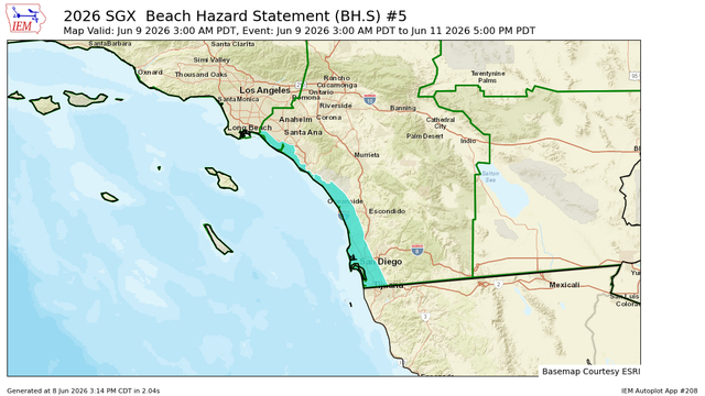
SGX continues Beach Hazard Statement valid at Jun 9, 3:00 AM PDT for Orange County Coastal, San Diego County Coastal Areas [CA] till Jun 11, 5:00 PM PDT
https://mesonet.agron.iastate.edu/vtec/f/2026-O-CON-KSGX-BH-S-0005_2026-06-09T10:00Z
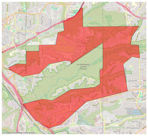
#EAS #WEA for San Diego: 1148am SDPD: There is a Fire near Torrey Hills. Evacuation Warning in effect. Prepare to evacuate. People who need extra time or with animals should evacuate now to 4275 EASTGATE MALL AT THE PARKING LOT. For a map and more information go to https://go.genasys.com/llmozu Source: Public Alert System #CAwx
** DO NOT RELY ON THIS FEED FOR LIFE SAFETY, SEEK OUT OFFICIAL SOURCES ***
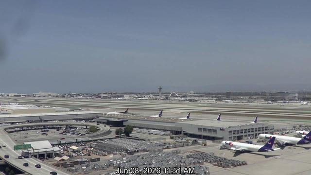
LAX at 10:53 AM
🌡️ 70.0 F
🌫️ 55.9 F dew point
🌬️ West-southwest at 10 knots
🔭 10 miles visibility
☁️ Broken clouds at 3000 feet; broken clouds at 14000 feet
⏱️ 1012.5 mb air pressure