The trees are turning. It's mid 80s in late October. Is it autumn or drought?
#arkansas #northwestarkansas #arwx #arweather #fall #autumn #leaves #trees #drought #drought2024 #climatechange
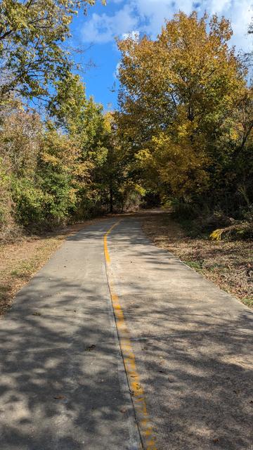
The trees are turning. It's mid 80s in late October. Is it autumn or drought?
#arkansas #northwestarkansas #arwx #arweather #fall #autumn #leaves #trees #drought #drought2024 #climatechange
#ARweather #ARwx
214
FXUS64 KLZK 202351
AFDLZK
Area Forecast Discussion
National Weather Service Little Rock AR
551 PM CST Tue Feb 20 2024
...New AVIATION...
.SHORT TERM...
(This evening through Thursday)
Issued at 145 PM CST Tue Feb 20 2024
This afternoon, elongated sfc ridging continues pushing Ewrd across
the Ern CONUS as a broad upper ridge moves in from the W. Abundant
sunshine, coupled with the buildi https://mesonet.agron.iastate.edu/p.php?pid=202402202351-KLZK-FXUS64-AFDLZK
#ARweather #ARwx
623
FXUS64 KLZK 201945
AFDLZK
Area Forecast Discussion
National Weather Service Little Rock AR
145 PM CST Tue Feb 20 2024
...New SHORT TERM, LONG TERM...
.SHORT TERM...
(This evening through Thursday)
Issued at 145 PM CST Tue Feb 20 2024
This afternoon, elongated sfc ridging continues pushing Ewrd across
the Ern CONUS as a broad upper ridge moves in from the W. Abundant
sunshine, coupled wi https://mesonet.agron.iastate.edu/p.php?pid=202402201945-KLZK-FXUS64-AFDLZK
#ARweather #ARwx
317
FXUS64 KLZK 201721 AAB
AFDLZK
Area Forecast Discussion...UPDATED
National Weather Service Little Rock AR
1121 AM CST Tue Feb 20 2024
...New AVIATION...
.SHORT TERM...
(Today through Wednesday Night)
Issued at 251 AM CST Tue Feb 20 2024
A quiet day will be seen this Tue in the wake of the upper shortwave
that is dropping SE over the state early this morning. Light
SRLY/SWRLY winds will b https://mesonet.agron.iastate.edu/p.php?pid=202402201721-KLZK-FXUS64-AFDLZK-AAB
#ARweather #ARwx
954
WGUS84 KLZK 201607
FLSLZK
Flood Statement
National Weather Service Little Rock AR
1007 AM CST Tue Feb 20 2024
...The Flood Warning is cancelled for the following rivers in
Arkansas...
White River At Clarendon affecting Arkansas and Monroe Counties.
ARC001-095-201715-
/O.CAN.KLZK.FL.W.0013.000000T0000Z-240220T1607Z/
/CLDA4.1.ER.240127T1300Z.240212T0200Z.000000T0000Z.NO/
1007 AM CST Tu https://mesonet.agron.iastate.edu/vtec/f/2024-O-CAN-KLZK-FL-W-0013_2024-02-20T16:07Z
#ARweather #ARwx
283
WGUS84 KLZK 201604
FLSLZK
Flood Statement
National Weather Service Little Rock AR
1004 AM CST Tue Feb 20 2024
...The Flood Warning continues for the following rivers in
Arkansas...
Ouachita River At Thatcher L&D affecting Bradley, Calhoun and
Union Counties.
For the Ouachita River...including Jones Mill Dcp, Arkadelphia,
Camden, Thatcher L&D...Minor flooding is forecast.
PRECAUT https://mesonet.agron.iastate.edu/vtec/f/2024-O-CON-KLZK-FL-W-0007_2024-02-20T16:04Z
#ARweather #ARwx
622
FXUS64 KLZK 201038 AAA
AFDLZK
Area Forecast Discussion...UPDATED
National Weather Service Little Rock AR
438 AM CST Tue Feb 20 2024
...New AVIATION...
.SHORT TERM...
(Today through Wednesday Night)
Issued at 251 AM CST Tue Feb 20 2024
A quiet day will be seen this Tue in the wake of the upper shortwave
that is dropping SE over the state early this morning. Light
SRLY/SWRLY winds will be https://mesonet.agron.iastate.edu/p.php?pid=202402201038-KLZK-FXUS64-AFDLZK-AAA
#ARweather #ARwx
759
FLUS44 KLZK 200855
HWOLZK
Hazardous Weather Outlook
National Weather Service Little Rock AR
255 AM CST Tue Feb 20 2024
ARZ004>008-014>017-024-025-031>034-039-042>047-052>057-062>069-
103-112-113-121>123-130-137-138-140-141-203-212-213-221>223-230-
237-238-240-241-313-340-341-211100-
Marion-Baxter-Fulton-Sharp-Randolph-Stone-Izard-Independence-
Lawrence-Cleburne-Jackson-Conway-Faulkner-White https://mesonet.agron.iastate.edu/p.php?pid=202402200855-KLZK-FLUS44-HWOLZK
#ARweather #ARwx
641
FXUS64 KLZK 200852
AFDLZK
Area Forecast Discussion
National Weather Service Little Rock AR
252 AM CST Tue Feb 20 2024
...New SHORT TERM, LONG TERM...
.SHORT TERM...
(Today through Wednesday Night)
Issued at 251 AM CST Tue Feb 20 2024
A quiet day will be seen this Tue in the wake of the upper shortwave
that is dropping SE over the state early this morning. Light
SRLY/SWRLY winds will be https://mesonet.agron.iastate.edu/p.php?pid=202402200852-KLZK-FXUS64-AFDLZK
#ARweather #ARwx
623
CDUS44 KLZK 200733
CLILZK
CLIMATE REPORT
NATIONAL WEATHER SERVICE LITTLE ROCK AR
133 AM CST TUE FEB 20 2024
...................................
...THE NORTH LITTLE ROCK CLIMATE SUMMARY FOR FEBRUARY 19 2024...
CLIMATE NORMAL PERIOD 1991 TO 2020
CLIMATE RECORD PERIOD 1975 TO 2024
WEATHER ITEM OBSERVED TIME RECORD YEAR NORMAL DEPARTURE LAST
VALUE (LST) VALUE https://mesonet.agron.iastate.edu/p.php?pid=202402200733-KLZK-CDUS44-CLILZK


