Sébastien Guimmara

10 Followers
21 Following
13 Posts
3D software engineer at @oslandia, maintainer of Giro3D (https://giro3d.org) 🌐

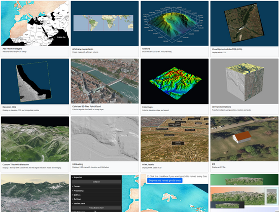
The Giro3D web library has a lot of new exciting features:

☁ Shading effects for point clouds

📎 Clipping plane support

📐 3D vectors (points, lines, polygons), and soon, 3D buildings

🗺️ Reprojection of map layers

👉 Try the examples on https://giro3d.org/examples/

https://oslandia.com/en/2023/08/28/les-dernieres-nouveautes-giro3d/

#web #3d #webgl #geospatial

Giro3D - examples

A versatile framework to visualize geospatial data in the browser.

Giro3D

Brave, Mozilla, and Vivaldi say NO 🛑 to Google's Web Environment Integrity proposal!

https://news.itsfoss.com/google-controversial-tracker/

#privacy

Google's New Web Environment Integrity Proposal Dismissed by Brave, Mozilla, and Vivaldi

When it is Google, you expect controversy. Let us find out what it is this time.

It's FOSS News
As the subreddit blackout begins, I wanted to say thank you from the bottom of my heart to the Reddit community and everyone standing up ❤️ Let's hope Reddit listens. https://www.reddit.com/r/apolloapp/comments/147a8xb/as_the_subreddit_blackout_begins_i_wanted_to_say/
As the subreddit blackout begins, I wanted to say thank you from the bottom of my heart to the Reddit community and everyone standing up

Hey all, Watching many subreddits go dark for tomorrow's blackout and before I log out, I just wanted to say it's been so incredibly amazing...

reddit
Apparently someone gave Ron DeSantis a hand-made snowflake at a Republican political rally in Davenport, Iowa last week. Look carefully: you'll see the word "Fascist" secretly embedded in it.

Look at the axis grid example to create a nice #3d grid to fit your datasets:

https://giro3d.org/examples/axisgrid.html

Giro3D - AxisGrid

Illustrates the use of the AxisGrid entity.

Giro3D

🆕 The #giro3d website now has a "getting started" page with step-by-step instructions on how to create a #3d map, and each example now display its source code !

https://giro3d.org/tutorials/getting-started.html

Giro3D - Getting started

A versatile framework to visualize geospatial data in the browser.

Giro3D
@garrettkjohnson have you tried padding the struct or changing the field order ?

La #GeoRDP approche !

💡 Une idée de news ? Une envie de parler de #carte ? d'outil #SIG ? de relayer un article, un tutoriel sur la #géographie ou la #géomatique ?

C'est par ici 👉 https://github.com/geotribu/website/issues/new/choose 👈

Build software better, together

GitHub is where people build software. More than 150 million people use GitHub to discover, fork, and contribute to over 420 million projects.

GitHub

🌍 At Oslandia we have been working on a #3D #geospatial library for #web applications. It is #opensource, based on THREE.js and called Giro3D. Lots of new features described in this article :

https://oslandia.com/en/2023/02/09/les-nouveautes-sur-giro3d/

👉 See the examples : https://giro3d.org/examples/index.html

🎮 You can also play with #CoG, #pointcloud data, BIM #IFC, #GIS Webservices and many types of data !

👩‍💻 We are looking for our next 3D engineer, see offer and apply here : https://oslandia.com/en/equipe/

Giro3D: what’s new?

The project has been swarming lately, so it's time for us to give you a little summary of everything that's been happening over the past few months! What is Giro3D? Giro3D is a 3D visualization library for web browsers, written in javascript and WebGL. Giro3D is based on THREE.js, leveraging all t

Oslandia
@autra @oguyot_c2c @erilem for vector sources, we actually let OL rasterize the source tile/vector data into a texture, so I guess it counts as using OL renderers ?