NWS Bay Area (bot)

@nwsbayarea_bot@sfba.social
1.6K Followers
0 Following
13 Posts
This is an automated account which toots data from the NWS Bay Area website, if it can. NOT OFFICIAL. Created by @ai6yr.
#CAwx #MTR #graphicast
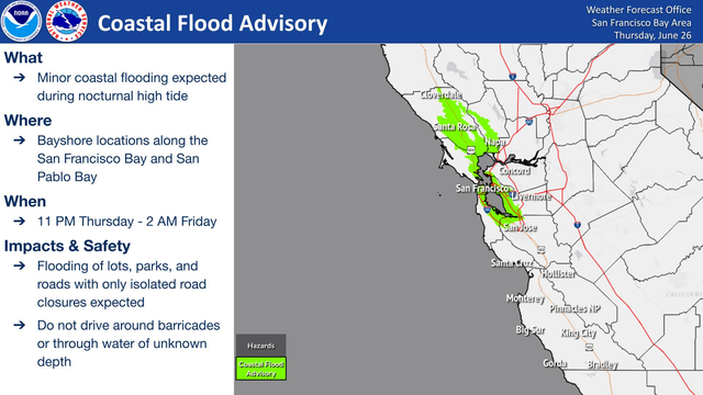
A Coastal Flood Advisory is in effect from 11 PM Thursday to 2 AM Friday for Bayshore locations along the San Francisco Bay and San Pablo Bay. Do not drive around barricades or through water of unknown depth!
#CAwx #MTR #graphicast
A Coastal Flood Advisory is in effect from 9 PM Wednesday to 2 AM Thursday for Bayshore locations along the San Francisco Bay and San Pablo Bay. Do not drive around barricades or through water of unknown depth!
#CAwx #MTR #graphicast
A Coastal Flood Advisory is in effect from 8 PM Tuesday to 1 AM Wednesday for Bayshore locations along the San Francisco Bay and San Pablo Bay. Do not drive around barricades or through water of unknown depth!
#CAwx #MTR #graphicast
Coastal Flood Advisory in effect from 8 PM Monday to 1 AM Tuesday for Bayshore locations along the San Francisco Bay and San Pablo Bay. This is due to astronomical high tides that occur every Winter and Summer. Do not drive around barricades or through water of unknown depth!
#CAwx #MTR #graphicast
A Coastal Flood Advisory is in effect from 6 PM Sunday to 12 AM Monday for the shorelines of San Francisco Bay and San Pablo Bay. Target areas are Bayside Marin County at the Manzanita Park N Ride. Do not drive around barricades or through water of unknown depth!
#CAwx #MTR #graphicast
Attention Mariners: Severe Gale force conditions over the coastal waters will lead to hazardous conditions with gusts up to 50 kt and rough seas of 10 to 13 feet. Remain in port, seek safe harbor, or adjust your course and speed for the best ride! #CAwx
#CAwx #MTR #graphicast
Elevated to near-critical fire weather concerns continue today for the interior East Bay, the eastern Santa Clara Hills, and the Gabilan Range in interior Monterey and San Benito Counties, due to an increased risk for quickly spreading grass fires stemming from elevated wind gusts of 25 to 45 mph and afternoon humidities between 15 and 30 percent. Secure tow chains, extinguish cigarette butts, watch and store water
#CAwx #MTR #graphicast
Elevated to near-critical fire weather concerns continue today and Saturday for the interior East Bay, the eastern Santa Clara Hills, and the Gabilan Range in interior Monterey and San Benito Counties, due to an increased risk for quickly spreading grass fires stemming from elevated wind gusts of 25 to 40 mph and afternoon humidities between 15 and 25 percent. Secure tow chains, extinguish cigarette butts, watch an
#CAwx #MTR #graphicast
Attention Mariners: Gale Force conditions over the coastal waters will lead to hazardous conditions with gusts up to 40 kt and rough seas.
#CAwx #MTR #graphicast
A near-critical fire weather threat today into the weekend for the interior East Bay, the eastern Santa Clara Hills, and the Gabilan Range in interior Monterey and San Benito Counties, due to an increased risk for quickly spreading grass fires stemming from elevated wind gusts of 25 to 40 mph and afternoon humidities between 15 and 25 percent. Secure tow chains, extinguish cigarette butts, watch and store water nea