D.J. Kayser

113 Followers
91 Following
114 Posts
Meteorologist & Data Specialist at Praedictix Weather. 2012 St. Cloud State Meteorology graduate. He/him. #mnwxhttps://linktr.ee/dkayserwx
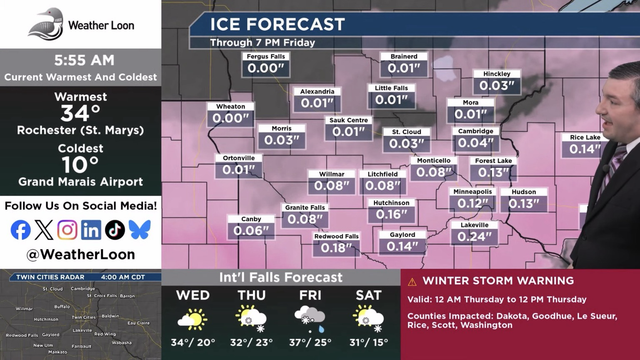
Snow and ice are on the way as we head into your Wednesday night and Thursday - and no, this is not an April Fools joke. Stay up-to-date with the latest on the storm over at WeatherLoon.com. I’ll be on the airwaves throughout the morning hours. #mnwx
6-9” (isolated higher amounts) expected Sunday morning to Monday morning, with high winds (35-45 mph) as well. Blizzard and Winter Storm Warnings have been issued. Expect rough travel and lots of snow removal! #mnwx
Well, this looks quite unpleasant for Thursday. #mnwx
We had a taste of fall last weekend - another one comes in later this week. Near to record breaking cold highs are anticipated Thursday. #mnwx #WinterIsComing
Oh look, more poor air quality in the forecast. #mnwx
This is what the very unhealthy (245 AQI) looks like this evening in Grand Marais. Yuk. 😷 #mnwx (Webcam credit: Lake Superior Trading Post and Visit Cook County)
Extreme Heat Warnings and Heat Advisories are in place this afternoon as heat index values climb above 100F from St. Cloud southward. #mnwx
June ended as the 36th wettest June on record for the Twin Cities, and the 10th wettest for St. Cloud. It was also the 22nd wettest for both Rochester and Hibbing, and the 26th wettest for Brainerd. #mnwx
Here are the official snow totals for the 2024-25 season across the state and surrounding areas. As of today (July 1st), the numbers reset, and we start looking toward the 2025-26 snow season. Meanwhile... it's already July? #mnwx
Soggy, chilly, windy weather expected for the #MNTwins tonight - if they can get the games in, that is. The potentially good news? Models have rain decreasing in intensity toward game time (5:10 PM for last night's suspended game - game two 30 minutes after that one ends). #mnwx