
Although the eruption activity has diminished quite fast, it's not over yet. Also, the start of this eruption was absolutely massive. Let us compare lava area with the previous eruptions at #Fagradalsfjall and number of eruptive days with this one.
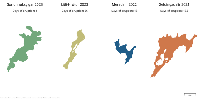
Although the eruption activity has diminished quite fast, it's not over yet. Also, the start of this eruption was absolutely massive. Let us compare lava area with the previous eruptions at #Fagradalsfjall and number of eruptive days with this one.
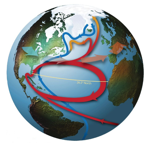
Will the #AMOC collapse by 2025?
Here's what we know from direct observations (since 2004). A thread.
Image from Srokosz & Bryden (2015) https://shorturl.at/ryB34
1/11
Back to Spain after 2 months at University of Iceland (Reykjavik).
Trying to measure snow depth with ICESat-2 and the ArcticDEM over cloudy Iceland.
The air temperature here is the water temperature of the warm pools there. Acclimatizing is needed :)

Abstract. The unprecedented precision of satellite laser altimetry data from the NASA ICESat-2 mission and the increasing availability of high-resolution elevation datasets open new opportunities to measure snow depth in mountains, a critical variable for ecosystem and water resource monitoring. We retrieved snow depth over the upper Tuolumne basin (California, USA) for 3 years by differencing ICESat-2 ATL06 snow-on elevations and various snow-off digital elevation models. Snow depth derived from ATL06 data only (snow-on and snow-off) offers a poor temporal and spatial coverage, limiting its potential utility. However, using a digital terrain model from airborne lidar surveys as the snow-off elevation source yielded a snow depth accuracy of ∼ 0.2 m (bias) and precision of ∼ 1 m (random error) across the basin, with an improved precision of 0.5 m for low slopes (< 10∘), compared to eight reference airborne lidar snow depth maps. Snow depths derived from ICESat-2 ATL06 and a satellite photogrammetry digital elevation model have a larger bias and reduced precision, partly induced by increased errors in forested areas. These various combinations of repeated ICESat-2 snow surface elevation measurements with satellite or airborne products will enable tailored approaches to map snow depth and estimate water resource availability in mountainous areas with limited snow depth observations.


I went to the European Geosciences Union General Assembly in Wien (hum...about 3 weeks ago) #EGU23 @EuroGeosciences
I presented a way to measure snow depth with #ICESat2 @nasa (https://zenodo.org/record/7892450#.ZF5NYKXP02w) and projections of the snowpack evolution in spanish mountains (https://zenodo.org/record/7892437#.ZF5NYaXP02w)
I went there by train (Grenoble-Geneva-Zürich-Wien, Wien-Zürich-Paris-Barcelona). Night train between Wien and Zürich always got delayed ~2h, keep that in mind before planning your trip!
Pico presentation EGU 2023 The unprecedented precision of the altimetry satellite ICESat-2 and the increasing availability of high-resolution elevation datasets open new opportunities to measure snow depth in the mountains, a critical variable for ecosystems and water resources monitoring. We retrieved snow depth over the upper Tuolumne basin (California, USA) for three years by differencing ICESat-2 ATL06 snow-on elevations and various snow-off elevation sources, including ATL06 and external digital elevation models. The snow presence of each ATL06 segment (i.e. point measurements regularly spaced every 20 m) can be determined from the number of photons returned by the ground surface. Snow depth derived from ATL06 data only (snow-on and snow-off) provided a poor temporal and spatial coverage, limiting its utility. However, using airborne lidar or satellite photogrammetry elevation models as snow-off elevation source yielded an accuracy of ~0.2 m (bias), a precision of ~0.5 m for low slopes and ~1.2 m for steeper areas, compared to eight reference airborne lidar snow depth maps. The snow depth derived from ICESat-2 ATL06 will help address the challenge of measuring the snow depth in unmonitored mountainous areas. How to cite: Deschamps-Berger, C., Gascoin, S., Shean, D., Besso, H., Guiot, A., and López Moreno, J. I.: A new opportunity to measure snow depth from space: evaluation of retrievals from ICESat-2 using airborne laser-scanning data, EGU General Assembly 2023, Vienna, Austria, 24–28 Apr 2023, EGU23-7537, https://doi.org/10.5194/egusphere-egu23-7537, 2023.
